Enable Location

We need your location to show you interesting places around you

Discover nearby places

Find interesting locations and hidden gems around you

Precise directions

Get accurate directions and distances to places

Your location is never shared with other users. It's only used when you tap the location button.

Log in to your account

Start exploring — it's free

Trusted by 61,429 travelers worldwide

Continue with Google
Continue with Apple
or

We will send you a code to connect

By continuing, you accept our Terms and Conditions and our Privacy Policy

Check your inbox

We've sent a pincode in your inbox. Please enter the code below.

Marietta–Williamstown Interstate Bridge

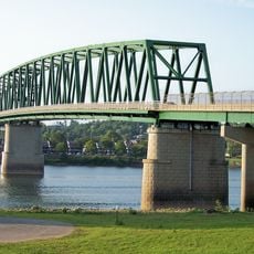
Marietta–Williamstown Interstate Bridge, Road bridge connecting Marietta, Ohio and Williamstown, West Virginia, United States

Description

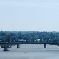
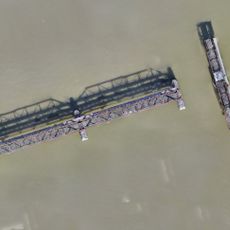
The Marietta-Williamstown Interstate Bridge crosses the Ohio River with four lanes carrying Interstate 77 traffic between the two states. The structure serves as a modern river crossing that handles thousands of vehicles daily and forms a key part of regional transportation infrastructure.

History

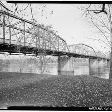
The current bridge replaced an earlier crossing in 1967 as part of a broader infrastructure development project in the region. The original 1903 structure pioneered an innovative design approach that influenced bridge engineering of its era.

Culture

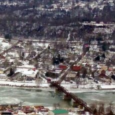
The bridge links two neighboring communities and shapes the daily routines of people traveling between Ohio and West Virginia for work and visits. It has become woven into the fabric of how residents in both states move through their regions.

Practical

The bridge is part of Interstate 77 and connects directly to both cities, making navigation straightforward. Visitors should expect active traffic and plan for delays during peak travel times.

Did you know?

The current structure retains elements from the original 1903 design, blending modern engineering with historical legacy. This rare combination demonstrates how innovative engineering ideas can be carried forward across generations.

Location
Location
Inception
1967
Official opening
1967
GPS coordinates
39.40306,-81.43111
Latest update
December 14, 2025 13:07

AroundUs brings together thousands of curated places, local tips, and hidden gems, enriched daily by 60,000 contributors worldwide. Discover all places nearby (Ohio).

Around this place
Mound Cemetery
United States of America

Mound Cemetery

2.6 km
Marietta Earthworks
United States of America

Marietta Earthworks

2.6 km
Fort Harmar
United States of America

Fort Harmar

2.4 km
Buckley Island
United States of America

Buckley Island

985 m
Start Westward Memorial
United States of America

Start Westward Memorial

2.7 km
Williamstown Bridge
United States of America

Williamstown Bridge

1.6 km
Harmar Historic District
United States of America

Harmar Historic District

2.4 km
The Castle
United States of America

The Castle

2.8 km
Marietta Historic District
United States of America

Marietta Historic District

2.7 km
Washington County Courthouse
United States of America

Washington County Courthouse

2.6 km
Tomlinson Mansion
United States of America

Tomlinson Mansion

2.8 km
David Putnam House
United States of America

David Putnam House

2.6 km
First Unitarian Church of Marietta
United States of America

First Unitarian Church of Marietta

2.4 km
The Castle
United States of America

The Castle

2.8 km
Peoples Bank Theatre
United States of America

Peoples Bank Theatre

2.4 km
Mid-Ohio Valley Players Theatre
United States of America

Mid-Ohio Valley Players Theatre

2.4 km
Children's Toy & Doll Museum
United States of America

Children's Toy & Doll Museum

2.6 km
Putnam Street Bridge
United States of America

Putnam Street Bridge

2.6 km
Muskingum Academy, 1797 - Birth of Higher Education in Ohio
United States of America

Muskingum Academy, 1797 - Birth of Higher Education in Ohio

2.3 km
Erwin Hall
United States of America

Erwin Hall

2.3 km
Putnam Street Bridge
United States of America

Putnam Street Bridge

2.6 km
Conus Mound
United States of America

Conus Mound

2.6 km
The Henry Fearing House
United States of America

The Henry Fearing House

2.6 km
Harmar Bridge
United States of America

Harmar Bridge

2.4 km
Old Muskingum Lockhouse
United States of America

Old Muskingum Lockhouse

2.4 km
Fort Harmar Monument
United States of America

Fort Harmar Monument

2.4 km
Ohio National Guard Armory
United States of America

Ohio National Guard Armory

2.4 km
C. William O'Neill (1916-1978)
United States of America

C. William O'Neill (1916-1978)

2.6 km
Show the full map
« Marietta–Williamstown Interstate Bridge - Road bridge connecting Marietta, Ohio and Williamstown, West Virginia, United States » is provided by Around Us (aroundus.com). Images and texts are derived from Wikimedia project under a Creative Commons license. You are allowed to copy, distribute, and modify copies of this page, under the conditions set by the license, as long as this note is clearly visible.

Discover hidden gems everywhere you go!

From secret cafés to breathtaking viewpoints, skip the crowded tourist spots and find places that match your style. Our app makes it easy with voice search, smart filtering, route optimization, and insider tips from travelers worldwide. Download now for the complete mobile experience.

Around Us App Screenshot

A unique approach to discovering new places

Le Figaro

All the places worth exploring

France Info

A tailor-made excursion in just a few clicks

20 Minutes

Around Us
Travel Guide & Maps
Download

Send to your phone

QR Code
1

Open the camera app on your mobile.

2

Point at the QR code with your camera. A notification will appear.

3

Tap the notification to open the link.