Enable Location

We need your location to show you interesting places around you

Discover nearby places

Find interesting locations and hidden gems around you

Precise directions

Get accurate directions and distances to places

Your location is never shared with other users. It's only used when you tap the location button.

Marine Corps Air Facility Walnut Ridge

Log in to your account

Start exploring — it's free

Trusted by 61,908 travelers worldwide

Continue with Google
Continue with Apple
or

We will send you a code to connect

By continuing, you accept our Terms and Conditions and our Privacy Policy

Check your inbox

We've sent a pincode in your inbox. Please enter the code below.

Marine Corps Air Facility Walnut Ridge

Marine Corps Air Facility Walnut Ridge, Military training facility in Walnut Ridge, Arkansas.

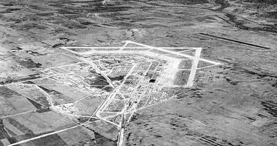
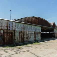
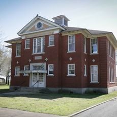
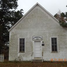
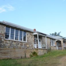
Marine Corps Air Facility Walnut Ridge is a former military flight training school with three runways, several hangars, and support buildings in northeast Arkansas. The facility was converted into a regional airport after World War II and continues to operate as Walnut Ridge Regional Airport.

The facility began in 1942 as a basic flight training school for the Army Air Forces and trained thousands of pilots during the war. After 1945, it was repurposed to process thousands of surplus military aircraft for civilian reuse.

The Wings of Honor Museum displays wartime photographs and military documents from when the facility operated. Visitors can see what daily life looked like for pilots and staff stationed here during that period.

The site is accessible today as a public airport with the museum open to visitors. Before planning a visit, check current opening hours since the museum's schedule can vary seasonally.

Five smaller satellite airfields once surrounded the main complex to support pilot training operations. Today these auxiliary fields are no longer visible, but their existence reveals how extensive the training operation once was.

The community of curious travelers

AroundUs brings together thousands of curated places, local tips, and hidden gems, enriched daily by 60,000 contributors worldwide.

Start exploring
Location
Inception
1942
GPS coordinates
36.12470,-90.92500
Latest update
December 12, 2025 09:00
Around this place
Davidsonville Historic State Park
United States of America

Davidsonville Historic State Park

12.3 km
Crowley's Ridge State Park
United States of America

Crowley's Ridge State Park

25 km
Powhatan Historic State Park
United States of America

Powhatan Historic State Park

17.7 km
Lake Frierson State Park
United States of America

Lake Frierson State Park

25.3 km
Black River Bridge
United States of America

Black River Bridge

15 km
Randolph County Courthouse
United States of America

Randolph County Courthouse

15.7 km
Cache River Bridge
United States of America

Cache River Bridge

11 km
Mercantile Bank Building
United States of America

Mercantile Bank Building

37.3 km
West Washington Avenue Historic District
United States of America

West Washington Avenue Historic District

37.3 km
Old Randolph County Courthouse
United States of America

Old Randolph County Courthouse

15.6 km
St. Louis-San Francisco Overpass
United States of America

St. Louis-San Francisco Overpass

24 km
Cedar Grove School No. 81
United States of America

Cedar Grove School No. 81

23.3 km
Crowley's Ridge State Park-Comfort Station
United States of America

Crowley's Ridge State Park-Comfort Station

25.5 km
Crowley's Ridge State Park-Bathhouse
United States of America

Crowley's Ridge State Park-Bathhouse

25.1 km
Lawrence County Courthouse
United States of America

Lawrence County Courthouse

6.8 km
Building Number 29
United States of America

Building Number 29

481 m
Powhatan Methodist Church
United States of America

Powhatan Methodist Church

18.2 km
US Sen. Hattie Caraway Gravesite
United States of America

US Sen. Hattie Caraway Gravesite

36.1 km
Holly Grove Presbyterian Church
United States of America

Holly Grove Presbyterian Church

30.6 km
Eddie Mae Herron Center & Museum
United States of America

Eddie Mae Herron Center & Museum

16.1 km
Rice-Upshaw House
United States of America

Rice-Upshaw House

37 km
Portia School
United States of America

Portia School

13.8 km
Old Union School
United States of America

Old Union School

22 km
Crowley's Ridge State Park-Dining Hall
United States of America

Crowley's Ridge State Park-Dining Hall

25 km
Crowley's Ridge State Park-Bridge
United States of America

Crowley's Ridge State Park-Bridge

25.2 km
Dr. John Octavius Hatcher House
United States of America

Dr. John Octavius Hatcher House

24.1 km
Ravenden Springs School
United States of America

Ravenden Springs School

34.2 km
Imboden Methodist Episcopal Church, South
United States of America

Imboden Methodist Episcopal Church, South

24.1 km
Show the full map
« Marine Corps Air Facility Walnut Ridge - Military training facility in Walnut Ridge, Arkansas » is provided by Around Us (aroundus.com). Images and texts are derived from Wikimedia project under a Creative Commons license. You are allowed to copy, distribute, and modify copies of this page, under the conditions set by the license, as long as this note is clearly visible.

Discover hidden gems everywhere you go!

From secret cafés to breathtaking viewpoints, skip the crowded tourist spots and find places that match your style. Our app makes it easy with voice search, smart filtering, route optimization, and insider tips from travelers worldwide. Download now for the complete mobile experience.

Around Us App Screenshot

A unique approach to discovering new places

Le Figaro

All the places worth exploring

France Info

A tailor-made excursion in just a few clicks

20 Minutes

Around Us
Travel Guide & Maps
Download

Send to your phone

QR Code
1

Open the camera app on your mobile.

2

Point at the QR code with your camera. A notification will appear.

3

Tap the notification to open the link.