Enable Location

We need your location to show you interesting places around you

Discover nearby places

Find interesting locations and hidden gems around you

Precise directions

Get accurate directions and distances to places

Your location is never shared with other users. It's only used when you tap the location button.

Palisades State Park

Log in to your account

Start exploring — it's free

Trusted by 62,857 travelers worldwide

Continue with Google
Continue with Apple
or

We will send you a code to connect

By continuing, you accept our Terms and Conditions and our Privacy Policy

Check your inbox

We've sent a pincode in your inbox. Please enter the code below.

Palisades State Park

Palisades State Park, State park in Minnehaha County, United States.

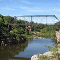
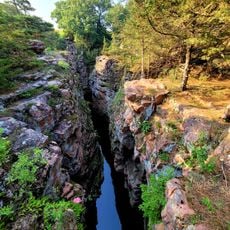
Palisades State Park is a South Dakota state park where Split Rock Creek cuts through deep gorges flanked by pink Sioux quartzite cliffs. The rocky landscape spans 435 acres and features 5 hiking trails, camping facilities with 111 sites and 10 cabins, plus rock climbing areas.

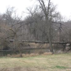
The area was settled in 1865 when pioneers established a town near Split Rock Creek and built a flour mill. Water from the creek powered this mill, forming the basis of early settlement in the region.

Native peoples mined catlinite from this area to craft ceremonial pipes used in spiritual rituals. The material held sacred importance in their traditional practices.

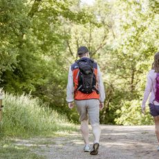
The park has well-marked hiking trails of varying difficulty and designated climbing spots throughout the grounds. Visitors should be aware that the pink rock surfaces become slippery when wet, so sturdy footwear is advisable.

The pink quartzite formations here rank among the oldest exposed rocks in South Dakota at over 1 billion years old. They offer visitors a rare glimpse into the geological forces that shaped the region during Earth's ancient past.

The community of curious travelers

AroundUs brings together thousands of curated places, local tips, and hidden gems, enriched daily by 60,000 contributors worldwide.

Start exploring
Location
GPS coordinates
43.68750,-96.51690
Latest update
December 10, 2025 20:04
Around this place
KDLT tower
United States of America

KDLT tower

20.6 km
Falls Park
United States of America

Falls Park

21.9 km
United States of America

Zip Feed Tower

22.5 km
Old Minnehaha County Courthouse
United States of America

Old Minnehaha County Courthouse

22.8 km
Old Courthouse Museum
United States of America

Old Courthouse Museum

22.8 km
United States of America

Beaver Creek Nature Area

14.5 km
U.S. Bank Building
United States of America

U.S. Bank Building

23.1 km
Renner Lutheran Church
United States of America

Renner Lutheran Church

16.7 km
Orpheum Theatre
United States of America

Orpheum Theatre

22.8 km
Eighth Street Bridge
United States of America

Eighth Street Bridge

22.8 km
Shafer Round Barn
United States of America

Shafer Round Barn

19.4 km
St. Peter's Lutheran Church
United States of America

St. Peter's Lutheran Church

21.9 km
Carnegie Free Public Library
United States of America

Carnegie Free Public Library

21.8 km
Palisades Bridge
United States of America

Palisades Bridge

180 m
Sioux Falls National Bank Building
United States of America

Sioux Falls National Bank Building

23 km
Great Bear Recreation Park
United States of America

Great Bear Recreation Park

16.8 km
John Rowe House
United States of America

John Rowe House

20.6 km
Odd Fellows Home of Dell Rapids
United States of America

Odd Fellows Home of Dell Rapids

22.6 km
Dell Rapids Water Tower
United States of America

Dell Rapids Water Tower

22.1 km
William G. Milne House
United States of America

William G. Milne House

22 km
Gina Smith Campbell Bathhouse
United States of America

Gina Smith Campbell Bathhouse

21 km
Sioux Falls Police Department
United States of America

Sioux Falls Police Department

22.7 km
Gitchie Manitou State Preserve
United States of America

Gitchie Manitou State Preserve

22.2 km
Josephine Martin Glidden Memorial Chapel
United States of America

Josephine Martin Glidden Memorial Chapel

21.7 km
Devil's Gulch Park
United States of America

Devil's Gulch Park

4.3 km
Bridge at Iverson Crossing
United States of America

Bridge at Iverson Crossing

18.9 km
Cherry Rock Park Bridge
United States of America

Cherry Rock Park Bridge

22.5 km
Railroad bridge over Sioux River
United States of America

Railroad bridge over Sioux River

22.7 km
Show the full map
« Palisades State Park - State park in Minnehaha County, United States » is provided by Around Us (aroundus.com). Images and texts are derived from Wikimedia project under a Creative Commons license. You are allowed to copy, distribute, and modify copies of this page, under the conditions set by the license, as long as this note is clearly visible.

Discover hidden gems everywhere you go!

From secret cafés to breathtaking viewpoints, skip the crowded tourist spots and find places that match your style. Our app makes it easy with voice search, smart filtering, route optimization, and insider tips from travelers worldwide. Download now for the complete mobile experience.

Around Us App Screenshot

A unique approach to discovering new places

Le Figaro

All the places worth exploring

France Info

A tailor-made excursion in just a few clicks

20 Minutes

Around Us
Travel Guide & Maps
Download

Send to your phone

QR Code
1

Open the camera app on your mobile.

2

Point at the QR code with your camera. A notification will appear.

3

Tap the notification to open the link.