Enable Location

We need your location to show you interesting places around you

Discover nearby places

Find interesting locations and hidden gems around you

Precise directions

Get accurate directions and distances to places

Your location is never shared with other users. It's only used when you tap the location button.

KDLT tower

Log in to your account

Start exploring — it's free

Trusted by 61,905 travelers worldwide

Continue with Google
Continue with Apple
or

We will send you a code to connect

By continuing, you accept our Terms and Conditions and our Privacy Policy

Check your inbox

We've sent a pincode in your inbox. Please enter the code below.

KDLT tower

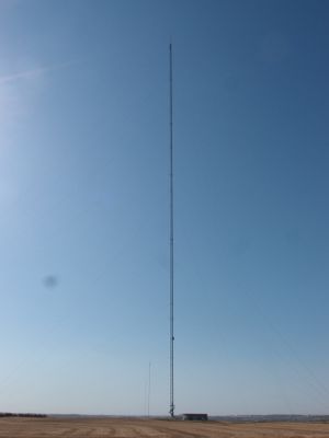
KDLT tower, Television tower in Rowena, South Dakota, US

KDLT tower is a television transmission tower near Rowena in South Dakota that rises significantly above the surrounding landscape. The structure features a lattice framework and is topped with red aircraft warning lights that are visible at night and during the day.

The current tower began broadcasting in the late 1990s as a replacement for an older analog transmission structure that had served the region for decades. That earlier installation stood until it was destroyed by severe weather in 2022.

The tower functions as a key broadcast hub connecting rural South Dakota communities with television programming and local news. For residents across the region, it represents an essential link to information and entertainment in their daily lives.

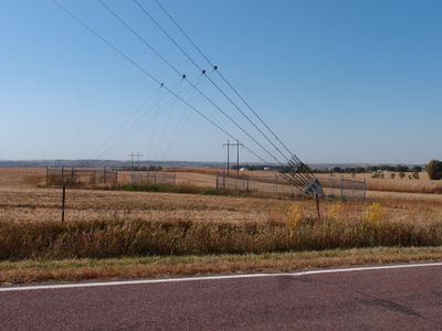
The tower stands in rural South Dakota and is visible from several local roads, making it relatively easy to locate. A side road near Rowena provides a good vantage point to view the structure against the sky.

A viral video from 2015 captured a technician replacing a bulb at extreme height, drawing millions of viewers worldwide before flight regulations restricted such documentation. The footage highlighted the dangerous work conditions maintenance crews regularly face.

The community of curious travelers

AroundUs brings together thousands of curated places, local tips, and hidden gems, enriched daily by 60,000 contributors worldwide.

Start exploring
Location
Inception
August 19, 1998
GPS coordinates
43.50500,-96.55640
Latest update
December 17, 2025 08:09
Around this place
Falls Park
United States of America

Falls Park

14.6 km
Blood Run Site
United States of America

Blood Run Site

4.7 km
CenturyLink Tower
United States of America

CenturyLink Tower

14.8 km
United States of America

Zip Feed Tower

14.4 km
Washington Pavilion of Arts and Science
United States of America

Washington Pavilion of Arts and Science

14.6 km
Good Earth State Park
United States of America

Good Earth State Park

4.5 km
South Dakota School for the Deaf
United States of America

South Dakota School for the Deaf

12.6 km
Queen Bee Mill
United States of America

Queen Bee Mill

14.6 km
Old Courthouse Museum
United States of America

Old Courthouse Museum

14.8 km
Federal Building and United States Courthouse
United States of America

Federal Building and United States Courthouse

14.3 km
United States of America

Beaver Creek Nature Area

6 km
Calvary Cathedral
United States of America

Calvary Cathedral

14.4 km
Security Bank Building
United States of America

Security Bank Building

14.7 km
U.S. Bank Building
United States of America

U.S. Bank Building

14.7 km
All Saints School Main Building
United States of America

All Saints School Main Building

14.3 km
Orpheum Theatre
United States of America

Orpheum Theatre

14.7 km
Eighth Street Bridge
United States of America

Eighth Street Bridge

14.5 km
Shafer Round Barn
United States of America

Shafer Round Barn

8.6 km
Grand Lodge and Library of the Ancient Free and Accepted Masons
United States of America

Grand Lodge and Library of the Ancient Free and Accepted Masons

14.5 km
Carpenter Building
United States of America

Carpenter Building

14.5 km
Sioux Falls National Bank Building
United States of America

Sioux Falls National Bank Building

14.5 km
Great Bear Recreation Park
United States of America

Great Bear Recreation Park

11.9 km
All Saints Historic District
United States of America

All Saints Historic District

14.1 km
Gitchie Manitou State Preserve
United States of America

Gitchie Manitou State Preserve

3.1 km
Josephine Martin Glidden Memorial Chapel
United States of America

Josephine Martin Glidden Memorial Chapel

12.3 km
Bridge at Iverson Crossing
United States of America

Bridge at Iverson Crossing

4.5 km
Cherry Rock Park Bridge
United States of America

Cherry Rock Park Bridge

12.5 km
Railroad bridge over Sioux River
United States of America

Railroad bridge over Sioux River

13.7 km
Show the full map
« KDLT tower - Television tower in Rowena, South Dakota, US » is provided by Around Us (aroundus.com). Images and texts are derived from Wikimedia project under a Creative Commons license. You are allowed to copy, distribute, and modify copies of this page, under the conditions set by the license, as long as this note is clearly visible.

Discover hidden gems everywhere you go!

From secret cafés to breathtaking viewpoints, skip the crowded tourist spots and find places that match your style. Our app makes it easy with voice search, smart filtering, route optimization, and insider tips from travelers worldwide. Download now for the complete mobile experience.

Around Us App Screenshot

A unique approach to discovering new places

Le Figaro

All the places worth exploring

France Info

A tailor-made excursion in just a few clicks

20 Minutes

Around Us
Travel Guide & Maps
Download

Send to your phone

QR Code
1

Open the camera app on your mobile.

2

Point at the QR code with your camera. A notification will appear.

3

Tap the notification to open the link.