Enable Location

We need your location to show you interesting places around you

Discover nearby places

Find interesting locations and hidden gems around you

Precise directions

Get accurate directions and distances to places

Your location is never shared with other users. It's only used when you tap the location button.

Log in to your account

Start exploring — it's free

Trusted by 61,918 travelers worldwide

Continue with Google
Continue with Apple
or

We will send you a code to connect

By continuing, you accept our Terms and Conditions and our Privacy Policy

Check your inbox

We've sent a pincode in your inbox. Please enter the code below.

Prophetstown State Recreation Area

Prophetstown State Recreation Area, Protected recreation area in Whiteside County, Illinois, United States.

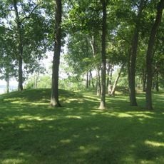
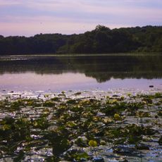
Prophetstown State Recreation Area is a protected park covering 53 acres along the south bank of the Rock River, offering trails for hiking, spots for birdwatching, and designated camping areas. The grounds include various facilities designed to accommodate visitors seeking outdoor recreation.

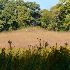
The land was once home to a Ho-Chunk village led by chief Wabokieshiek before it was destroyed during the Black Hawk War in 1832. This conflict fundamentally shaped the region's history and the fate of its inhabitants.

The site honors the heritage of Native Americans who once settled here, with the river location telling the story of their connection to the land. Visitors can learn about the lives of these earlier communities through the park's educational resources.

The park is accessible via Illinois Route 78 and features camping facilities for overnight stays. Seasonal flooding can occasionally affect access to certain areas of the grounds.

George S. Brydia, a local newspaper editor and former mayor, was instrumental in establishing this protected area. His work as a state representative helped bring this park initiative to life.

The community of curious travelers

AroundUs brings together thousands of curated places, local tips, and hidden gems, enriched daily by 60,000 contributors worldwide.

Start exploring
Location
GPS coordinates
41.67190,-89.92390
Latest update
December 14, 2025 09:41
Around this place
Birthplace of Ronald Reagan
United States of America

Birthplace of Ronald Reagan

12.3 km
H. C. Pitney Variety Store Building
United States of America

H. C. Pitney Variety Store Building

12.3 km
Sinnissippi Mounds
United States of America

Sinnissippi Mounds

26 km
Clinton Railroad Bridge
United States of America

Clinton Railroad Bridge

28.4 km
Morrison-Rockwood State Park
United States of America

Morrison-Rockwood State Park

20 km
Gateway Bridge
United States of America

Gateway Bridge

28.4 km
Paul W. Dillon Home
United States of America

Paul W. Dillon Home

24.2 km
Albany Mounds State Historic Site
United States of America

Albany Mounds State Historic Site

28.2 km
Main Street Historic District
United States of America

Main Street Historic District

12.3 km
United States of America

Whiteside County Courthouse

15.8 km
Sterling Masonic Temple
United States of America

Sterling Masonic Temple

22.8 km
Fulton Commercial Historic District
United States of America

Fulton Commercial Historic District

23.2 km
First Congregational Church of Sterling
United States of America

First Congregational Church of Sterling

23.2 km
Odell Building
United States of America

Odell Building

15.6 km
Morrison Main Street Historic District
United States of America

Morrison Main Street Historic District

15.7 km
United States of America

Whiteside County Fair Grounds

15 km
Morrison Covered Bridge 13-98-B
United States of America

Morrison Covered Bridge 13-98-B

16.7 km
United States of America

Old Stage Line Monument

24.1 km
Lyndon Bridge
United States of America

Lyndon Bridge

4.4 km
United States of America

Veterans Monument

22.4 km
United States of America

Liberty Bell Monument

22.8 km
United States of America

Cross Creek Golf Course

16.3 km
United States of America

Rock River Golf Course

25.9 km
United States of America

Deer Valley Golf Club

20.7 km

Norrish Auditorium

15.8 km

Grandon Civic Center

23.3 km
United States of America

RB&W Park Amphitheatre

23.1 km
United States of America

President Ronald Reagan as a boy

12.4 km
Show the full map
« Prophetstown State Recreation Area - Protected recreation area in Whiteside County, Illinois, United States » is provided by Around Us (aroundus.com). Images and texts are derived from Wikimedia project under a Creative Commons license. You are allowed to copy, distribute, and modify copies of this page, under the conditions set by the license, as long as this note is clearly visible.

Discover hidden gems everywhere you go!

From secret cafés to breathtaking viewpoints, skip the crowded tourist spots and find places that match your style. Our app makes it easy with voice search, smart filtering, route optimization, and insider tips from travelers worldwide. Download now for the complete mobile experience.

Around Us App Screenshot

A unique approach to discovering new places

Le Figaro

All the places worth exploring

France Info

A tailor-made excursion in just a few clicks

20 Minutes

Around Us
Travel Guide & Maps
Download

Send to your phone

QR Code
1

Open the camera app on your mobile.

2

Point at the QR code with your camera. A notification will appear.

3

Tap the notification to open the link.