Chest opened
+${chestReward.xp} XP
Explorer
NOUVEAU ×${chestReward.collectible.quantity}
tapez pour fermer
Chest locked

Open chests in the app

Around Us is built for your phone — chests unlock when you walk, explore and capture nearby places.

Enable Location

We need your location to show you interesting places around you

Discover nearby places

Find interesting locations and hidden gems around you

Precise directions

Get accurate directions and distances to places

Your location is never shared with other users. It's only used when you tap the location button.

Log in to your account

Start exploring — it's free

Trusted by 72,942 travelers worldwide

Continue with Google
Continue with Apple
or

We will send you a code to connect

By continuing, you accept our Terms and Conditions and our Privacy Policy

Check your inbox

We've sent a pincode in your inbox. Please enter the code below.

Robin Road Trestle
Discussion Reviews Photo
1.4k Popularity

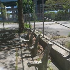
Robin Road Trestle, Railway bridge in Staten Island, United States.

Robin Road Trestle is a railway bridge on Staten Island that crosses Robin Road Avenue, constructed from steel framework with sturdy support beams designed to carry trains. The structure links Austin Avenue and Doty Avenue and represents the only surviving trestle from the island's former rail network.

The bridge was built in 1936 with federal public works funding and served as part of the South Beach Branch of the Staten Island Railway. Train operations ceased in 1953, leaving the structure dormant for decades.

The trestle marks where rail lines once connected different parts of Staten Island and shaped how residents moved around their community. It represents an era when trains were central to daily life on the island.

The bridge sits between Austin Avenue and Doty Avenue and can be reached on foot with clear views from nearby streets of the metal structure. The site is open and easily accessible to visitors interested in industrial heritage and urban history.

Some local residents envision converting the abandoned trestle into an elevated park with greenery, inspired by similar projects like Manhattan's High Line. This ambitious plan could breathe new life into the structure and create an unexpected public gathering space on the island.

The community of curious travelers

AroundUs brings together thousands of curated places, local tips, and hidden gems, enriched daily by 60,000 contributors worldwide.

Start exploring
Location
GPS coordinates
40.59410,-74.06580
Latest update
December 14, 2025 17:00
Around this place
Verrazzano-Narrows Bridge
United States of America

Verrazzano-Narrows Bridge

2.2 km
Battery Weed
United States of America

Battery Weed

1.6 km
Alice Austen House
United States of America

Alice Austen House

2.3 km
Fort Lafayette
United States of America

Fort Lafayette

2.8 km
Silver Lake, Staten Island
United States of America

Silver Lake, Staten Island

4 km
Fort Tompkins
United States of America

Fort Tompkins

767 m
United States of America

Old Town, Staten Island

1.7 km
Billiou-Stillwell-Perine House
United States of America

Billiou-Stillwell-Perine House

3 km
National American Indian Memorial
United States of America

National American Indian Memorial

1.4 km
Garibaldi-Meucci Museum
United States of America

Garibaldi-Meucci Museum

2.4 km
Tappen Park
United States of America

Tappen Park

3.8 km
Harbor Defense Museum
United States of America

Harbor Defense Museum

3.3 km
Buono Beach
United States of America

Buono Beach

2.4 km
John J. Carty Park
United States of America

John J. Carty Park

3.6 km
Our Lady of Mount Carmel Grotto
United States of America

Our Lady of Mount Carmel Grotto

2.2 km
Fort Wadsworth Light
United States of America

Fort Wadsworth Light

1.6 km
Augustinian Academy
United States of America

Augustinian Academy

3.5 km
Fort Tompkins Light
United States of America

Fort Tompkins Light

1.6 km
Elm Tree Beacon Light
United States of America

Elm Tree Beacon Light

4.2 km
364 and 390 Van Duzer Street
United States of America

364 and 390 Van Duzer Street

4.1 km
Boardman–Mitchell House
United States of America

Boardman–Mitchell House

3.5 km
Casemate Fort, Whiting Quadrangle
United States of America

Casemate Fort, Whiting Quadrangle

3.2 km
Edgewater Village Hall and Tappen Park
United States of America

Edgewater Village Hall and Tappen Park

3.8 km
Independence Manor
United States of America

Independence Manor

3.9 km
Dover Patrol Monument
United States of America

Dover Patrol Monument

3.3 km
Paramount Theatre
United States of America

Paramount Theatre

3.9 km
South Beach
United States of America

South Beach

553 m
Stapleton Library
United States of America

Stapleton Library

3.7 km
Show the full map
Reviews
Share your experience

No review yet

Discussions
Start a discussion...

No discussion yet

« Robin Road Trestle - Railway bridge in Staten Island, United States » is provided by Around Us (aroundus.com). Images and texts are derived from Wikimedia project under a Creative Commons license. You are allowed to copy, distribute, and modify copies of this page, under the conditions set by the license, as long as this note is clearly visible.

Discover hidden gems everywhere you go!

From secret cafés to breathtaking viewpoints, skip the crowded tourist spots and find places that match your style. Our app makes it easy with voice search, smart filtering, route optimization, and insider tips from travelers worldwide. Download now for the complete mobile experience.

Around Us App Screenshot

A unique approach to discovering new places

Le Figaro

All the places worth exploring

France Info

A tailor-made excursion in just a few clicks

20 Minutes

Around Us
Travel Guide & Maps
Download

Send to your phone

QR Code
1

Open the camera app on your mobile.

2

Point at the QR code with your camera. A notification will appear.

3

Tap the notification to open the link.