Silver Springs State Fish and Wildlife Area

Log in to your account

AroundUs is a community-driven map of interesting places, built by curious explorers like you. It grows with every review, story, and photo you share.
Connect to save your favorite spots, contribute locations, and create personalized routes.
Continue with Google
Continue with Apple
Continue with X
Continue with Facebook
Continue with email
By continuing, you accept our Terms and Conditions and our Privacy Policy
Create an account

Silver Springs State Fish and Wildlife Area

Add to collection
Map
Suggest a change
Share

Silver Springs State Fish and Wildlife Area, Wildlife management area in Kendall County, United States

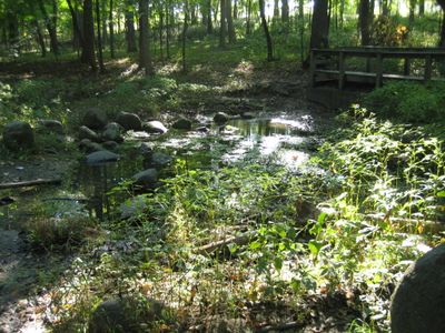
Silver Springs State Fish and Wildlife Area is a 1,350-acre wildlife management area in Kendall County that extends along the Fox River in northern Illinois. The landscape contains two artificial lakes, natural springs, oak woodlands, and prairie grasslands that support diverse habitats.

The state of Illinois purchased this land in 1969 as part of a regional initiative to establish new parks in the northern part of the state. This acquisition reflected growing interest in wildlife management and public outdoor recreation during that period.

The park serves as a gathering place for hunters, anglers, and nature enthusiasts from the surrounding region who share a tradition of outdoor pursuits. It functions as a community hub where people connect through seasonal activities and wildlife conservation efforts.

The site offers seven miles of equestrian trails, fishing access at two lakes, and designated hunting zones for game and upland birds. Visitors should come prepared for variable weather and plan their visit based on their preferred activity, as different areas serve specific recreational uses.

A natural spring at the southern boundary feeds a pool that remains unfrozen even during the harshest winters, creating a shimmering silver appearance in sunlight. This remarkable feature gave the park its distinctive name.

Location: Kendall County

GPS coordinates: 41.62750,-88.52250

Latest update: December 10, 2025 20:03

Photos
Around this place
Farnsworth House
United States of America

Farnsworth House

1.4 km
United States of America

Rich Harvest Farms

14.4 km
Leland Tower
United States of America

Leland Tower

22.5 km
Stolp Island
United States of America

Stolp Island

22.5 km
Plano Stone Church
United States of America

Plano Stone Church

3.7 km
Old Second National Bank
United States of America

Old Second National Bank

22.3 km
Von KleinSmid Mansion
United States of America

Von KleinSmid Mansion

8.4 km
Sam and Ruth VanSickle Ford House
United States of America

Sam and Ruth VanSickle Ford House

19.5 km
Grand Army of the Republic Hall
United States of America

Grand Army of the Republic Hall

22.4 km
Col. Ira C. Copley Mansion
United States of America

Col. Ira C. Copley Mansion

22.1 km
Keystone Building
United States of America

Keystone Building

22.4 km
Aurora Public Library
United States of America

Aurora Public Library

22.3 km
Kendall County Courthouse
United States of America

Kendall County Courthouse

6.4 km
Albert H. Sears House
United States of America

Albert H. Sears House

4.2 km
Graham Building
United States of America

Graham Building

22.4 km
Sandwich City Hall
United States of America

Sandwich City Hall

8.4 km
Stolp Woolen Mill Store
United States of America

Stolp Woolen Mill Store

22.4 km
Gray–Watkins Mill
United States of America

Gray–Watkins Mill

13.3 km
West Side Historic District
United States of America

West Side Historic District

21.5 km
Healy Chapel
United States of America

Healy Chapel

22.1 km
Hauge Lutheran Church
United States of America

Hauge Lutheran Church

21.7 km
Ephraim Smith House
United States of America

Ephraim Smith House

17.8 km
Lewis Steward House
United States of America

Lewis Steward House

4.2 km
Yorkville School
United States of America

Yorkville School

6.6 km
Bristol Congregational Church
United States of America

Bristol Congregational Church

6.6 km
Middle Avenue Historic District
United States of America

Middle Avenue Historic District

21.8 km
Masonic Temple
United States of America

Masonic Temple

22.4 km
LaSalle Street Auto Row Historic District
United States of America

LaSalle Street Auto Row Historic District

22.4 km
Show the full map
Reviews

Visited this place? Tap the stars to rate it and share your experience / photos with the community! Try now! You can cancel it anytime.

« Silver Springs State Fish and Wildlife Area - Wildlife management area in Kendall County, United States » is provided by Around Us (aroundus.com). Images and texts are derived from Wikimedia project under a Creative Commons license. You are allowed to copy, distribute, and modify copies of this page, under the conditions set by the license, as long as this note is clearly visible.

Discover hidden gems everywhere you go!

From secret cafés to breathtaking viewpoints, skip the crowded tourist spots and find places that match your style. Our app makes it easy with voice search, smart filtering, route optimization, and insider tips from travelers worldwide. Download now for the complete mobile experience.

Around Us App Screenshot

A unique approach to discovering new places

Le Figaro

All the places worth exploring

France Info

A tailor-made excursion in just a few clicks

20 Minutes