Spade Farm Covered Bridge

Log in to your account

AroundUs is a community-driven map of interesting places, built by curious explorers like you. It grows with every review, story, and photo you share.
Connect to save your favorite spots, contribute locations, and create personalized routes.
By continuing, you accept our Terms and Conditions and our Privacy Policy
Add to collection
Map
Suggest a change
Share

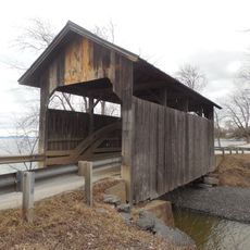
Spade Farm Covered Bridge, Covered bridge in Ferrisburgh, United States.

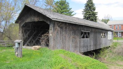
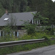
Spade Farm Covered Bridge is a wooden covered span crossing a drainage channel with a Town lattice design. The structure measures approximately 85 feet (26 meters) long and about 17 feet (5 meters) wide, serving pedestrians today.

Built around 1850 by Justin Miller, the bridge originally stood in a different location before being moved to its current site. The relocation in 1958 to the Vermont Trading Company property saved it from being torn down and replaced.

The interior walls feature old advertisements that show what local businesses and community life looked like in past decades. These painted ads give visitors a window into how people shopped and worked in the area long ago.

The bridge sits near State Route 7 and is easy to locate along the road. It remains accessible for walking, with no barriers blocking entry from the Vermont Trading Company property nearby.

The bridge takes its name from Sam Spade, a local farmer whose request led to its relocation and saved it from demolition. This act of advocacy by one resident preserved a historic structure that would otherwise have been lost.

Location: Ferrisburgh

GPS coordinates: 44.24140,-73.23310

Latest update: December 14, 2025 17:03

Photos
Around this place
Mount Philo State Park
United States of America

Mount Philo State Park

4.4 km
Rokeby
United States of America

Rokeby

2.2 km
Grand Isle State Park
United States of America

Grand Isle State Park

11.4 km
Holmes Creek Covered Bridge
United States of America

Holmes Creek Covered Bridge

10.9 km
Champlain II
United States of America

Champlain II

12.2 km
Quinlan's Covered Bridge
United States of America

Quinlan's Covered Bridge

5.5 km
Sequin Covered Bridge
United States of America

Sequin Covered Bridge

8.5 km
McNeil Homestead
United States of America

McNeil Homestead

8.8 km
Charlotte Center Historic District
United States of America

Charlotte Center Historic District

8.1 km
Hawley's Ferry House
United States of America

Hawley's Ferry House

5.2 km
Essex Village Historic District
United States of America

Essex Village Historic District

12.4 km
Tavern on Mutton Hill
United States of America

Tavern on Mutton Hill

9.3 km
Essex County Home and Farm
United States of America

Essex County Home and Farm

14.2 km
Gen. Samuel Strong House
United States of America

Gen. Samuel Strong House

8.9 km
Union Meetinghouse
United States of America

Union Meetinghouse

4.1 km
Cicero Goddard Peck House
United States of America

Cicero Goddard Peck House

14.1 km
Bixby Memorial Free Library
United States of America

Bixby Memorial Free Library

8.4 km
Starksboro Village Meeting House
United States of America

Starksboro Village Meeting House

14.1 km
Hoag Gristmill and Knight House Complex
United States of America

Hoag Gristmill and Knight House Complex

13.1 km
Vergennes Residential Historic District
United States of America

Vergennes Residential Historic District

8.6 km
Samuel Paddock Strong House
United States of America

Samuel Paddock Strong House

9.2 km
Field Farm
United States of America

Field Farm

3.2 km
Bottum Farm
United States of America

Bottum Farm

12.3 km
Vergennes Historic District
United States of America

Vergennes Historic District

8.3 km
Capts. Louis and Philomene Daniels House
United States of America

Capts. Louis and Philomene Daniels House

8.2 km
Monkton Town Hall
United States of America

Monkton Town Hall

8.7 km
Monkton Borough Baptist Church
United States of America

Monkton Borough Baptist Church

7.7 km
Lake Champlain Maritime Museum
United States of America

Lake Champlain Maritime Museum

11.1 km
Show the full map
Reviews

Visited this place? Tap the stars to rate it and share your experience / photos with the community! Try now! You can cancel it anytime.

« Spade Farm Covered Bridge - Covered bridge in Ferrisburgh, United States » is provided by Around Us (aroundus.com). Images and texts are derived from Wikimedia project under a Creative Commons license. You are allowed to copy, distribute, and modify copies of this page, under the conditions set by the license, as long as this note is clearly visible.

Discover hidden gems everywhere you go!

From secret cafés to breathtaking viewpoints, skip the crowded tourist spots and find places that match your style. Our app makes it easy with voice search, smart filtering, route optimization, and insider tips from travelers worldwide. Download now for the complete mobile experience.

Around Us App Screenshot

A unique approach to discovering new places

Le Figaro

All the places worth exploring

France Info

A tailor-made excursion in just a few clicks

20 Minutes