Enable Location

We need your location to show you interesting places around you

Discover nearby places

Find interesting locations and hidden gems around you

Precise directions

Get accurate directions and distances to places

Your location is never shared with other users. It's only used when you tap the location button.

Champlain II

Log in to your account

Start exploring — it's free

Trusted by 63,187 travelers worldwide

Continue with Google
Continue with Apple
or

We will send you a code to connect

By continuing, you accept our Terms and Conditions and our Privacy Policy

Check your inbox

We've sent a pincode in your inbox. Please enter the code below.

Discussion Reviews 1 Photos
1.1k Popularity

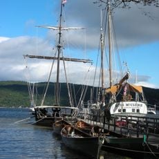
Champlain II, archaeological site in Essex County, United States of America

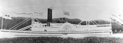
Champlain II is a shipwreck in Lake Champlain in Essex County, New York, located near Westport. Originally built as the Oakes Ames in 1868, this paddle wheeler was later renamed Champlain II and used for passenger service before sinking in 1875 after striking a rock.

Built in 1868 in Burlington, Vermont, as the Oakes Ames, the vessel was designed to transport railroad cars across the lake. The ship was renamed Champlain II in 1874 and converted to passenger service before striking a rock and sinking in 1875.

The site is protected with restricted access to preserve the archaeological remains and prevent disturbance. Those interested in learning about the wreck can explore historical records and archival collections, as direct access to the submerged site is limited.

The wreck sank in 1875 under unusual circumstances when the pilot was under the influence of morphine, leading to a navigation error that caused the ship to strike a rock. The remains provide a rare window into 19th-century shipbuilding techniques and the dangers early lake travelers faced.

The community of curious travelers

AroundUs brings together thousands of curated places, local tips, and hidden gems, enriched daily by 60,000 contributors worldwide.

Start exploring
Location
GPS coordinates
44.20583,-73.37750
Latest update
February 9, 2026 07:40
Around this place
Mount Philo State Park
United States of America

Mount Philo State Park

15.2 km
Rokeby
United States of America

Rokeby

11.3 km
Grand Isle State Park
United States of America

Grand Isle State Park

3.3 km
Spade Farm Covered Bridge
United States of America

Spade Farm Covered Bridge

12.2 km
Barber's Point Light
United States of America

Barber's Point Light

6.1 km
Essex County Fairgrounds
United States of America

Essex County Fairgrounds

6.1 km
Holmes Creek Covered Bridge
United States of America

Holmes Creek Covered Bridge

16.1 km
Octagonal Schoolhouse
United States of America

Octagonal Schoolhouse

11.1 km
Foothills Baptist Church
United States of America

Foothills Baptist Church

10.9 km
Addison Baptist Church
United States of America

Addison Baptist Church

14.3 km
McNeil Homestead
United States of America

McNeil Homestead

12.4 km
Hawley's Ferry House
United States of America

Hawley's Ferry House

7.4 km
Essex Village Historic District
United States of America

Essex Village Historic District

12 km
Essex County Home and Farm
United States of America

Essex County Home and Farm

6.2 km
Gen. Samuel Strong House
United States of America

Gen. Samuel Strong House

10.6 km
Union Meetinghouse
United States of America

Union Meetinghouse

10.5 km
Camp Dudley Road Historic District
United States of America

Camp Dudley Road Historic District

6.6 km
Lake View Grange No. 970
United States of America

Lake View Grange No. 970

5.3 km
Bixby Memorial Free Library
United States of America

Bixby Memorial Free Library

10.8 km
Vergennes Residential Historic District
United States of America

Vergennes Residential Historic District

10.9 km
Samuel Paddock Strong House
United States of America

Samuel Paddock Strong House

10.5 km
Field Farm
United States of America

Field Farm

14.4 km
Sheldon-Owens Farm
United States of America

Sheldon-Owens Farm

15.6 km
Abraham Aiken House
United States of America

Abraham Aiken House

15.4 km
Vergennes Historic District
United States of America

Vergennes Historic District

10.7 km
District School No. 1
United States of America

District School No. 1

8.8 km
Capts. Louis and Philomene Daniels House
United States of America

Capts. Louis and Philomene Daniels House

10.4 km
Lake Champlain Maritime Museum
United States of America

Lake Champlain Maritime Museum

1.9 km
Show the full map
Reviews
Share your experience

No review yet

Discussions
Start a discussion...

No discussion yet

« Champlain II - archaeological site in Essex County, United States of America » is provided by Around Us (aroundus.com). Images and texts are derived from Wikimedia project under a Creative Commons license. You are allowed to copy, distribute, and modify copies of this page, under the conditions set by the license, as long as this note is clearly visible.

Discover hidden gems everywhere you go!

From secret cafés to breathtaking viewpoints, skip the crowded tourist spots and find places that match your style. Our app makes it easy with voice search, smart filtering, route optimization, and insider tips from travelers worldwide. Download now for the complete mobile experience.

Around Us App Screenshot

A unique approach to discovering new places

Le Figaro

All the places worth exploring

France Info

A tailor-made excursion in just a few clicks

20 Minutes

Around Us
Travel Guide & Maps
Download

Send to your phone

QR Code
1

Open the camera app on your mobile.

2

Point at the QR code with your camera. A notification will appear.

3

Tap the notification to open the link.