Trostletown Bridge

Log in to your account

AroundUs is a community-driven map of interesting places, built by curious explorers like you. It grows with every review, story, and photo you share.
Connect to save your favorite spots, contribute locations, and create personalized routes.
By continuing, you accept our Terms and Conditions and our Privacy Policy
Add to collection
Map
Suggest a change
Share

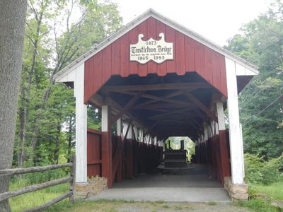
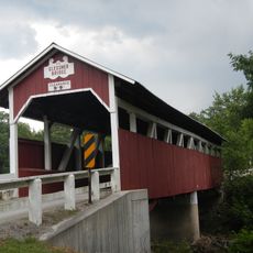
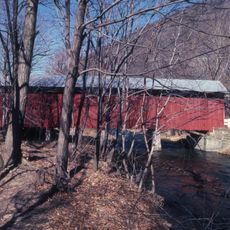
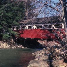
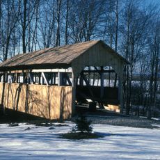
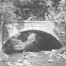
Trostletown Bridge, Covered bridge in Quemahoning Township, Pennsylvania, US

Trostlestown Bridge is a covered timber structure that spans Stony Creek using a Kingpost truss design with distinctive half-height plank siding. The roof features shingled construction typical of covered bridges from this period.

The structure was built in 1845 and remains one of ten surviving covered bridges in Somerset County. It gained National Register recognition in 1980 for its historical importance.

The bridge takes its name from the nearby settlement of Trostlestown and served as a vital connection for the local community. Today visitors can observe how the traditional timber construction shaped both the structure and its role in the region.

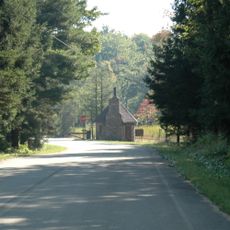
The best access is via U.S. Route 30 heading southeast from Stoystown into Quemahoning Township. The location is somewhat remote, so expect a quieter setting without crowds of visitors.

The structure is known for its distinctive half-height plank siding, a regional feature of bridge design from the 1800s. This particular design element sets it apart from many other covered bridges nearby.

Location: Pennsylvania

GPS coordinates: 40.09583,-78.94556

Latest update: December 14, 2025 18:02

Photos
Around this place
Flight 93 National Memorial
United States of America

Flight 93 National Memorial

5.5 km
Pennsylvania Railroad 3750
United States of America

Pennsylvania Railroad 3750

22.3 km
Laurel Summit State Park
United States of America

Laurel Summit State Park

19.7 km
Somerset County Courthouse
United States of America

Somerset County Courthouse

14.8 km
John P. Saylor Trail
United States of America

John P. Saylor Trail

21.2 km
Daniel B. Zimmerman Mansion
United States of America

Daniel B. Zimmerman Mansion

13.8 km
Glessner Bridge
United States of America

Glessner Bridge

8.1 km
Somerset Historical Center
United States of America

Somerset Historical Center

11.9 km
New Baltimore Bridge
United States of America

New Baltimore Bridge

19.1 km
Windber Historic District
United States of America

Windber Historic District

18.4 km
Uptown Somerset Historic District
United States of America

Uptown Somerset Historic District

14.9 km
Matthew Hair Farm
United States of America

Matthew Hair Farm

10.8 km
Shaffer's Bridge
United States of America

Shaffer's Bridge

20.7 km
Cairnbrook Historic District
United States of America

Cairnbrook Historic District

11.4 km
Boswell Historic District
United States of America

Boswell Historic District

10.3 km
Shade Furnace Archaeological District
United States of America

Shade Furnace Archaeological District

11.8 km
Stoystown Historic District
United States of America

Stoystown Historic District

1.1 km
Walter's Mill Bridge
United States of America

Walter's Mill Bridge

11.8 km
Bridge in Jenner Township
United States of America

Bridge in Jenner Township

10.2 km
Tower of Voices
United States of America

Tower of Voices

5.5 km
Laurel Mountain State Park
United States of America

Laurel Mountain State Park

20.2 km
Wall of Names
United States of America

Wall of Names

5.9 km
Western Overlook Trail
United States of America

Western Overlook Trail

5.7 km
Pasquerilla Performing Arts Center
United States of America

Pasquerilla Performing Arts Center

21.5 km
Flight 93 National Memorial entrance sign
United States of America

Flight 93 National Memorial entrance sign

5.3 km
Flight 93 National Memorial Visitor Center
United States of America

Flight 93 National Memorial Visitor Center

5.5 km
Flight 93 National Memorial Visitor Shelter
United States of America

Flight 93 National Memorial Visitor Shelter

6.3 km
Wetlands Bridge
United States of America

Wetlands Bridge

6.3 km
Show the full map
Reviews

Visited this place? Tap the stars to rate it and share your experience / photos with the community! Try now! You can cancel it anytime.

« Trostletown Bridge - Covered bridge in Quemahoning Township, Pennsylvania, US » is provided by Around Us (aroundus.com). Images and texts are derived from Wikimedia project under a Creative Commons license. You are allowed to copy, distribute, and modify copies of this page, under the conditions set by the license, as long as this note is clearly visible.

Discover hidden gems everywhere you go!

From secret cafés to breathtaking viewpoints, skip the crowded tourist spots and find places that match your style. Our app makes it easy with voice search, smart filtering, route optimization, and insider tips from travelers worldwide. Download now for the complete mobile experience.

Around Us App Screenshot

A unique approach to discovering new places

Le Figaro

All the places worth exploring

France Info

A tailor-made excursion in just a few clicks

20 Minutes