Enable Location

We need your location to show you interesting places around you

Discover nearby places

Find interesting locations and hidden gems around you

Precise directions

Get accurate directions and distances to places

Your location is never shared with other users. It's only used when you tap the location button.

Van Veghten's Bridge

Log in to your account

Start exploring — it's free

Trusted by 61,326 travelers worldwide

Continue with Google
Continue with Apple
or

We will send you a code to connect

By continuing, you accept our Terms and Conditions and our Privacy Policy

Check your inbox

We've sent a pincode in your inbox. Please enter the code below.

Van Veghten's Bridge

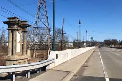
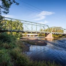
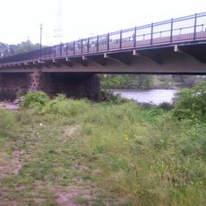
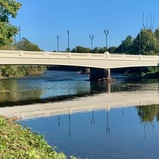
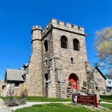
Van Veghten's Bridge, Road bridge spanning the Raritan River in Bridgewater Township, United States

Description

Van Veghten's Bridge is a road crossing over the Raritan River near Bridgewater that carries four lanes of Somerset County Route 533. The structure connects the Finderne section of Bridgewater with Manville, where North Main Street continues on the opposite side.

History

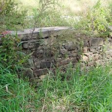
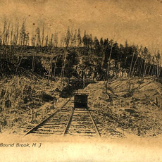
The original structure dates from the 18th century and was rebuilt multiple times, reflecting the region's growing transportation needs. The current form with stone arches and steel components came about through modernization work in the early 20th century.

Culture

The bridge takes its name from local residents who shaped the area, and it connects two communities that developed on opposite sides of the river. Today visitors can see how it functions as a vital link in the daily movement between neighboring towns.

Practical

The bridge is well lit during daylight and easily accessible from both sides, with pedestrian traffic flowing safely on wide walkways. Visitors should note that through traffic is active during peak hours, so planning a visit for early morning or late afternoon works better.

Did you know?

This location held military importance during 18th-century conflicts and was the site of attacks on river traffic. A visit today offers the chance to see a place that played a role in struggles over control of river crossings.

Location
GPS coordinates
40.55528,-74.58306
Latest update
December 14, 2025 18:02

AroundUs brings together thousands of curated places, local tips, and hidden gems, enriched daily by 60,000 contributors worldwide. Discover all places nearby (New Jersey).

Around this place
Duke Farms
United States of America

Duke Farms

2.9 km
Duke Gardens
United States of America

Duke Gardens

3.1 km
Wallace House
United States of America

Wallace House

3.6 km
Van Horne House
United States of America

Van Horne House

2.8 km
Old Dutch Parsonage
United States of America

Old Dutch Parsonage

3.7 km
Old Stone Arch Bridge
United States of America

Old Stone Arch Bridge

4.8 km
Somerset County Court House complex
United States of America

Somerset County Court House complex

2.8 km
Van Veghten House
United States of America

Van Veghten House

483 m
Staats House
United States of America

Staats House

5.3 km
Nevius Street Bridge
United States of America

Nevius Street Bridge

4.6 km
Colonial Park Arboretum and Gardens
United States of America

Colonial Park Arboretum and Gardens

5.2 km
Brook Arts Center
United States of America

Brook Arts Center

4.6 km
General John Frelinghuysen House
United States of America

General John Frelinghuysen House

4.2 km
Queen's Bridge
United States of America

Queen's Bridge

4.7 km
John Basilone Veterans Memorial Bridge
United States of America

John Basilone Veterans Memorial Bridge

4.7 km
West End Hose Company Number 3
United States of America

West End Hose Company Number 3

3.4 km
J. Harper Smith Mansion
United States of America

J. Harper Smith Mansion

3.8 km
Joseph and Minnie White House
United States of America

Joseph and Minnie White House

5.6 km
Presbyterian Church at Bound Brook
United States of America

Presbyterian Church at Bound Brook

4.6 km
Daniel Robert House
United States of America

Daniel Robert House

3.5 km
St. John's Episcopal Church
United States of America

St. John's Episcopal Church

3.5 km
Peters Brook
United States of America

Peters Brook

5.7 km
Buttermilk Falls
United States of America

Buttermilk Falls

4 km
First Reformed Church of Raritan
United States of America

First Reformed Church of Raritan

2.8 km
Chimney Rock Quarry
United States of America

Chimney Rock Quarry

3.6 km
Somerset County Courthouse
United States of America

Somerset County Courthouse

2.8 km
Lord Memorial Fountain
United States of America

Lord Memorial Fountain

2.7 km
Millstone School House
United States of America

Millstone School House

5.6 km
Show the full map
« Van Veghten's Bridge - Road bridge spanning the Raritan River in Bridgewater Township, United States » is provided by Around Us (aroundus.com). Images and texts are derived from Wikimedia project under a Creative Commons license. You are allowed to copy, distribute, and modify copies of this page, under the conditions set by the license, as long as this note is clearly visible.

Discover hidden gems everywhere you go!

From secret cafés to breathtaking viewpoints, skip the crowded tourist spots and find places that match your style. Our app makes it easy with voice search, smart filtering, route optimization, and insider tips from travelers worldwide. Download now for the complete mobile experience.

Around Us App Screenshot

A unique approach to discovering new places

Le Figaro

All the places worth exploring

France Info

A tailor-made excursion in just a few clicks

20 Minutes

Around Us
Travel Guide & Maps
Download

Send to your phone

QR Code
1

Open the camera app on your mobile.

2

Point at the QR code with your camera. A notification will appear.

3

Tap the notification to open the link.