Weaubleau structure

Log in to your account

AroundUs is a community-driven map of interesting places, built by curious explorers like you. It grows with every review, story, and photo you share.
Connect to save your favorite spots, contribute locations, and create personalized routes.
By continuing, you accept our Terms and Conditions and our Privacy Policy

Weaubleau structure

Add to collection
Map
Suggest a change
Share

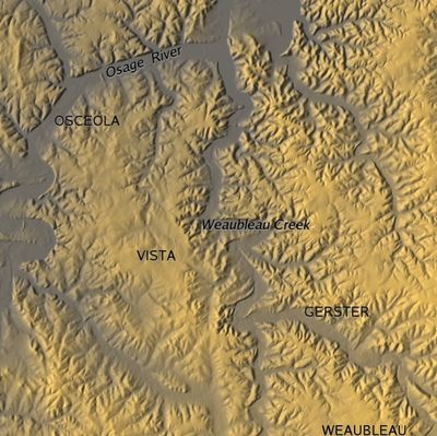
Weaubleau structure, Meteorite impact site in St. Clair County, Missouri, United States

The Weaubleau structure is a geological formation in Missouri created by an ancient impact event that left behind distinctive rock layers. The site displays compressed and fractured strata from different geological periods stacked in unusual arrangements across the landscape.

The landscape changed dramatically around 335 to 340 million years ago when a large object from space collided with this region. This collision compressed and jumbled the rock layers that originally lay flat and organized beneath the surface.

Local residents and geologists refer to specific spherical rock formations in the area as Missouri rock balls and Weaubleau eggs, which formed during the impact.

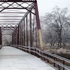
The area can be easily explored from nearby roads where rock fractures and disturbances are visible to the naked eye. The best times to visit are spring or autumn when weather is mild and views of the landscape features are clear.

At the center of the structure are rock formations that locals and geologists call by a distinctive nickname due to their rounded ball-like shape. These rocks formed during the impact event and stand out noticeably from the surrounding area.

Location: Missouri

GPS coordinates: 37.98330,-93.63330

Latest update: December 10, 2025 15:47

Photos
Around this place
Ha Ha Tonka State Park
United States of America

Ha Ha Tonka State Park

76.5 km
Truman Reservoir
United States of America

Truman Reservoir

37 km
Stockton Lake
United States of America

Stockton Lake

39.8 km
Bennett Spring State Park
United States of America

Bennett Spring State Park

74.4 km
Bridal Cave
United States of America

Bridal Cave

74.2 km
Rock Island Trail State Park
United States of America

Rock Island Trail State Park

63 km
Pomme de Terre State Park
United States of America

Pomme de Terre State Park

30.4 km
Harry S Truman State Park
United States of America

Harry S Truman State Park

37.1 km
Osage Village State Historic Site
United States of America

Osage Village State Historic Site

50.6 km
Fort Carondelet
United States of America

Fort Carondelet

51 km
Upper Bridge
United States of America

Upper Bridge

36.1 km
Caplinger Mills Historic District
United States of America

Caplinger Mills Historic District

25.6 km
George Dimmitt Memorial Hospital
United States of America

George Dimmitt Memorial Hospital

21.6 km
Gilmore Barn
United States of America

Gilmore Barn

74.2 km
Bolivar Public Library
United States of America

Bolivar Public Library

45.6 km
Vernon County Courthouse
United States of America

Vernon County Courthouse

65.6 km
Fiery Fork Conservation Area
United States of America

Fiery Fork Conservation Area

60.5 km
Greenfield Opera House
United States of America

Greenfield Opera House

65.9 km
Bates County Courthouse
United States of America

Bates County Courthouse

70.2 km
Papinville Marais des Cygnes River Bridge
United States of America

Papinville Marais des Cygnes River Bridge

53.3 km
Stockton Community Building
United States of America

Stockton Community Building

34.6 km
Glasgow Commercial Historic District
United States of America

Glasgow Commercial Historic District

32.9 km
South Main Street Historic District
United States of America

South Main Street Historic District

18.3 km
Bennett Spring Dining Lodge
United States of America

Bennett Spring Dining Lodge

74 km
Henry County Museum
United States of America

Henry County Museum

45 km
Bennett Spring State Park Shelter House and Water Gauge Station
United States of America

Bennett Spring State Park Shelter House and Water Gauge Station

74.4 km
SLSF Sac River Bridge
United States of America

SLSF Sac River Bridge

56.1 km
Caplinger Mills Bridge
United States of America

Caplinger Mills Bridge

25.7 km
Show the full map
Reviews

Visited this place? Tap the stars to rate it and share your experience / photos with the community! Try now! You can cancel it anytime.

« Weaubleau structure - Meteorite impact site in St. Clair County, Missouri, United States » is provided by Around Us (aroundus.com). Images and texts are derived from Wikimedia project under a Creative Commons license. You are allowed to copy, distribute, and modify copies of this page, under the conditions set by the license, as long as this note is clearly visible.

Discover hidden gems everywhere you go!

From secret cafés to breathtaking viewpoints, skip the crowded tourist spots and find places that match your style. Our app makes it easy with voice search, smart filtering, route optimization, and insider tips from travelers worldwide. Download now for the complete mobile experience.

Around Us App Screenshot

A unique approach to discovering new places

Le Figaro

All the places worth exploring

France Info

A tailor-made excursion in just a few clicks

20 Minutes