Enable Location

We need your location to show you interesting places around you

Discover nearby places

Find interesting locations and hidden gems around you

Precise directions

Get accurate directions and distances to places

Your location is never shared with other users. It's only used when you tap the location button.

Western Avenue Bridge

Log in to your account

Start exploring — it's free

Trusted by 62,559 travelers worldwide

Continue with Google
Continue with Apple
or

We will send you a code to connect

By continuing, you accept our Terms and Conditions and our Privacy Policy

Check your inbox

We've sent a pincode in your inbox. Please enter the code below.

Western Avenue Bridge

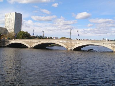
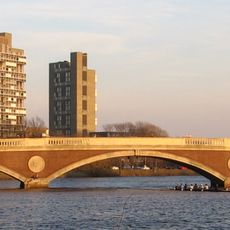
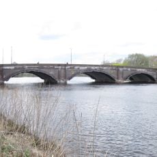
Western Avenue Bridge, Road bridge in Cambridge and Allston, Massachusetts, US

Western Avenue Bridge connects Cambridge and Allston across the Charles River using reinforced concrete construction with separate lanes for vehicles and pedestrians. The structure spans approximately 328 feet (100 meters) and maintains distinct vehicle and walking areas.

The bridge was built in 1924 and replaced an older leaf-draw structure that previously crossed the river. It was designed and constructed under the direction of engineer John R. Rablin from the Metropolitan District Commission.

The bridge displays modern design elements through its horizontal concrete joints and decorative parapets that shape the local landscape. These visual features connect it to other crossings of the Charles River throughout the area.

Traffic flows westbound across the bridge between Cambridge and Allston, while travelers heading east need to use the River Street Bridge instead. Plan your route accordingly if you need to travel in both directions.

The original 1924 design remains visible today in the ring stones and concrete details of the structure. These features visually connect it to the style of other crossings built during the same era on the Charles River.

The community of curious travelers

AroundUs brings together thousands of curated places, local tips, and hidden gems, enriched daily by 60,000 contributors worldwide.

Start exploring
Location
Official opening
1924
GPS coordinates
42.36420,-71.11690
Latest update
December 14, 2025 16:46
Around this place
Harvard Stadium
United States of America

Harvard Stadium

883 m
Harvard Lampoon Building
United States of America

Harvard Lampoon Building

828 m
John W. Weeks Bridge
United States of America

John W. Weeks Bridge

489 m
Anderson Memorial Bridge
United States of America

Anderson Memorial Bridge

739 m
Shell Oil Company "Spectacular" Sign
United States of America

Shell Oil Company "Spectacular" Sign

880 m
The Class of 1959 Chapel
United States of America

The Class of 1959 Chapel

602 m
Great Bridge
United States of America

Great Bridge

733 m
Ruth Mulan Chu Chao Center
United States of America

Ruth Mulan Chu Chao Center

369 m
River Street Bridge
United States of America

River Street Bridge

334 m
Tata Hall
United States of America

Tata Hall

318 m
Clifton Merriman Post Office Building
United States of America

Clifton Merriman Post Office Building

890 m
Harvard Houses Historic District
United States of America

Harvard Houses Historic District

653 m
Andrew Newman House
United States of America

Andrew Newman House

589 m
Ware Hall
United States of America

Ware Hall

903 m
Edmund Reardon House
United States of America

Edmund Reardon House

810 m
Ernst Flentje House
United States of America

Ernst Flentje House

718 m
Hiram Sands House
United States of America

Hiram Sands House

606 m
Franklin Street Park
United States of America

Franklin Street Park

648 m
Building at 106–108 Inman Street
United States of America

Building at 106–108 Inman Street

903 m
Building at 102–104 Inman Street
United States of America

Building at 102–104 Inman Street

903 m
Richard Hapgood House
United States of America

Richard Hapgood House

823 m
Sara Foster Colburn House
United States of America

Sara Foster Colburn House

802 m
Cheney Read House
United States of America

Cheney Read House

665 m
Upper Magazine Street Historic District
United States of America

Upper Magazine Street Historic District

829 m
Isaac Melvin House
United States of America

Isaac Melvin House

868 m
Stickney-Shepard House
United States of America

Stickney-Shepard House

801 m
Urban Rowhouse
United States of America

Urban Rowhouse

865 m
Buildings at 110–112 Inman Street
United States of America

Buildings at 110–112 Inman Street

903 m
Show the full map
« Western Avenue Bridge - Road bridge in Cambridge and Allston, Massachusetts, US » is provided by Around Us (aroundus.com). Images and texts are derived from Wikimedia project under a Creative Commons license. You are allowed to copy, distribute, and modify copies of this page, under the conditions set by the license, as long as this note is clearly visible.

Discover hidden gems everywhere you go!

From secret cafés to breathtaking viewpoints, skip the crowded tourist spots and find places that match your style. Our app makes it easy with voice search, smart filtering, route optimization, and insider tips from travelers worldwide. Download now for the complete mobile experience.

Around Us App Screenshot

A unique approach to discovering new places

Le Figaro

All the places worth exploring

France Info

A tailor-made excursion in just a few clicks

20 Minutes

Around Us
Travel Guide & Maps
Download

Send to your phone

QR Code
1

Open the camera app on your mobile.

2

Point at the QR code with your camera. A notification will appear.

3

Tap the notification to open the link.