Enable Location

We need your location to show you interesting places around you

Discover nearby places

Find interesting locations and hidden gems around you

Precise directions

Get accurate directions and distances to places

Your location is never shared with other users. It's only used when you tap the location button.

Monument Mountain

Log in to your account

Start exploring — it's free

Trusted by 62,442 travelers worldwide

Continue with Google
Continue with Apple
or

We will send you a code to connect

By continuing, you accept our Terms and Conditions and our Privacy Policy

Check your inbox

We've sent a pincode in your inbox. Please enter the code below.

Monument Mountain

Monument Mountain, Mountain summit in Berkshire County, Massachusetts, United States

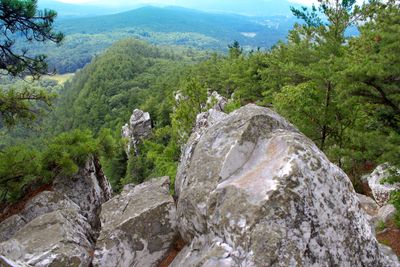
Monument Mountain is a quartzite ridge in Massachusetts with several trails that lead to viewpoints across the summit area. The rocky spine extends across multiple kilometers and offers different routes suitable for various skill levels.

Indigenous peoples including the Mohicans had deep roots in this region for centuries before European settlement arrived. In the 1800s it became known as a destination for writers and thinkers exploring the landscape.

The name comes from the mountain's distinctive shape that served as a landmark for travelers over centuries. Today visitors walk the same ridges where communities have gathered and passed through for generations.

Multiple trails of varying length let visitors choose a route based on how much time they have and their fitness level. Sturdy footwear and water are important because some sections are steep and the ridge can be windy.

A freestanding stone pillar called Devil's Pulpit rises near the summit and offers unexpected views that can stretch across four states on clear days. This isolated rock formation surprises many visitors as they explore the ridgeline.

The community of curious travelers

AroundUs brings together thousands of curated places, local tips, and hidden gems, enriched daily by 60,000 contributors worldwide.

Start exploring
Location
GPS coordinates
42.27370,-73.35233
Latest update
December 11, 2025 11:04
Around this place
The Mount
United States of America

The Mount

8.6 km
Norman Rockwell Museum
United States of America

Norman Rockwell Museum

2.1 km
Sedgwick Pie
United States of America

Sedgwick Pie

3.1 km
Naumkeag
United States of America

Naumkeag

3.5 km
Shadow Brook Farm Historic District
United States of America

Shadow Brook Farm Historic District

8.2 km
Chesterwood
United States of America

Chesterwood

1.3 km
Stockbridge Bowl
United States of America

Stockbridge Bowl

7.4 km
Mission House
United States of America

Mission House

3.2 km
Berkshire Theatre Festival
United States of America

Berkshire Theatre Festival

4.3 km
Berkshire Botanical Garden
United States of America

Berkshire Botanical Garden

3.2 km
Villa Virginia
United States of America

Villa Virginia

3.4 km
Stockbridge Casino
United States of America

Stockbridge Casino

4.3 km
South Lee Historic District
United States of America

South Lee Historic District

6.3 km
Merwin House (Stockbridge, Massachusetts)
United States of America

Merwin House (Stockbridge, Massachusetts)

3.3 km
Clinton African Methodist Episcopal Zion Church
United States of America

Clinton African Methodist Episcopal Zion Church

8.6 km
Housatonic Congregational Church
United States of America

Housatonic Congregational Church

2.1 km
Congregational Church of West Stockbridge
United States of America

Congregational Church of West Stockbridge

6.7 km
United States Post Office–Great Barrington Main
United States of America

United States Post Office–Great Barrington Main

8.2 km
West Stockbridge Town Hall
United States of America

West Stockbridge Town Hall

6.8 km
Ramsdell Public Library
United States of America

Ramsdell Public Library

2 km
Glendale Power House
United States of America

Glendale Power House

766 m
Citizens Hall
United States of America

Citizens Hall

5 km
West Stockbridge Grange No. 246
United States of America

West Stockbridge Grange No. 246

7 km
Elm-Maple-South Streets Historic District
United States of America

Elm-Maple-South Streets Historic District

3.3 km
Turn Park Art Space
United States of America

Turn Park Art Space

6.8 km
Monument Mountain
United States of America

Monument Mountain

3.1 km
Main Street Historic District
United States of America

Main Street Historic District

2.6 km
Old Curtisville Historic District
United States of America

Old Curtisville Historic District

5 km
Show the full map
« Monument Mountain - Mountain summit in Berkshire County, Massachusetts, United States » is provided by Around Us (aroundus.com). Images and texts are derived from Wikimedia project under a Creative Commons license. You are allowed to copy, distribute, and modify copies of this page, under the conditions set by the license, as long as this note is clearly visible.

Discover hidden gems everywhere you go!

From secret cafés to breathtaking viewpoints, skip the crowded tourist spots and find places that match your style. Our app makes it easy with voice search, smart filtering, route optimization, and insider tips from travelers worldwide. Download now for the complete mobile experience.

Around Us App Screenshot

A unique approach to discovering new places

Le Figaro

All the places worth exploring

France Info

A tailor-made excursion in just a few clicks

20 Minutes

Around Us
Travel Guide & Maps
Download

Send to your phone

QR Code
1

Open the camera app on your mobile.

2

Point at the QR code with your camera. A notification will appear.

3

Tap the notification to open the link.