Enable Location

We need your location to show you interesting places around you

Discover nearby places

Find interesting locations and hidden gems around you

Precise directions

Get accurate directions and distances to places

Your location is never shared with other users. It's only used when you tap the location button.

Crab Run Lane Truss Bridge

Log in to your account

Start exploring — it's free

Trusted by 62,545 travelers worldwide

Continue with Google
Continue with Apple
or

We will send you a code to connect

By continuing, you accept our Terms and Conditions and our Privacy Policy

Check your inbox

We've sent a pincode in your inbox. Please enter the code below.

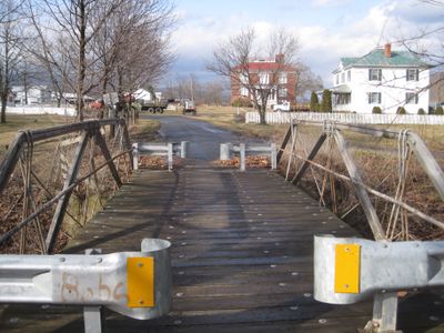
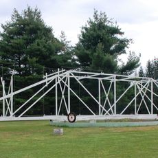
Crab Run Lane Truss Bridge, Steel pony truss bridge in Highland County, Virginia.

Crab Run Lane Truss Bridge is a steel structure in Highland County that carries pedestrians and cyclists across a small creek. The bridge employs a lattice-like framework design characteristic of bridges from the late 1800s.

The bridge was built in 1896 by West Virginia Bridge Works of Wheeling using discarded railroad rails as construction material. This approach provided a cost-effective way to repurpose industrial materials into durable infrastructure.

The bridge received recognition on both the Virginia Landmarks Register and the National Register of Historic Places in 2009 for its engineering significance.

The bridge is now protected as a historic structure and serves pedestrians and cyclists rather than vehicles. Visitors should check local conditions before visiting, as seasonal weather or maintenance work may occasionally restrict access.

The structure uses the patented Lane truss design, a specialized lattice form that is rarely seen today. This scarce construction method makes it an important example of early American bridge engineering.

The community of curious travelers

AroundUs brings together thousands of curated places, local tips, and hidden gems, enriched daily by 60,000 contributors worldwide.

Start exploring
Location
GPS coordinates
38.33500,-79.49000
Latest update
December 14, 2025 13:05
Around this place
United States National Radio Quiet Zone
United States of America

United States National Radio Quiet Zone

4.5 km
United States of America

Sugar Grove, West Virginia

26.9 km
Reddish Knob
United States of America

Reddish Knob

25.9 km
Green Bank Interferometer
United States of America

Green Bank Interferometer

32.4 km
Elliott Knob
United States of America

Elliott Knob

24.2 km
Ramsey's Draft Wilderness
United States of America

Ramsey's Draft Wilderness

12.7 km
Reber Radio Telescope
United States of America

Reber Radio Telescope

30.5 km
Wild Oak Trail
United States of America

Wild Oak Trail

21.3 km
40-foot telescope
United States of America

40-foot telescope

31.9 km
United States of America

Stokesville Observatory

29.6 km
Fort Edward Johnson
United States of America

Fort Edward Johnson

9.3 km
Monterey High School
United States of America

Monterey High School

11.9 km
Bowers House
United States of America

Bowers House

25.2 km
Deerfield School
United States of America

Deerfield School

17.3 km
Ananias Pitsenbarger Farm
United States of America

Ananias Pitsenbarger Farm

30.9 km
Intervale
United States of America

Intervale

30.4 km
Mansion House
United States of America

Mansion House

427 m
McClung Farm Historic District
United States of America

McClung Farm Historic District

8.6 km
The Wilderness
United States of America

The Wilderness

22.1 km
Mt. Zion Schoolhouse
United States of America

Mt. Zion Schoolhouse

31.7 km
Craigsville School
United States of America

Craigsville School

30 km
C.P. Jones House and Law Office
United States of America

C.P. Jones House and Law Office

11.8 km
Green Bank Observatory
United States of America

Green Bank Observatory

32.3 km
Green Bank Observatory Science Center
United States of America

Green Bank Observatory Science Center

30.5 km
300 foot Radio Telescope
United States of America

300 foot Radio Telescope

32.4 km
Green Bank Jansky Antenna
United States of America

Green Bank Jansky Antenna

30.4 km
Howard E. Tatel Radio Telescope
United States of America

Howard E. Tatel Radio Telescope

31.6 km
Green Bank 45ft telescope
United States of America

Green Bank 45ft telescope

31 km
Show the full map
« Crab Run Lane Truss Bridge - Steel pony truss bridge in Highland County, Virginia » is provided by Around Us (aroundus.com). Images and texts are derived from Wikimedia project under a Creative Commons license. You are allowed to copy, distribute, and modify copies of this page, under the conditions set by the license, as long as this note is clearly visible.

Discover hidden gems everywhere you go!

From secret cafés to breathtaking viewpoints, skip the crowded tourist spots and find places that match your style. Our app makes it easy with voice search, smart filtering, route optimization, and insider tips from travelers worldwide. Download now for the complete mobile experience.

Around Us App Screenshot

A unique approach to discovering new places

Le Figaro

All the places worth exploring

France Info

A tailor-made excursion in just a few clicks

20 Minutes

Around Us
Travel Guide & Maps
Download

Send to your phone

QR Code
1

Open the camera app on your mobile.

2

Point at the QR code with your camera. A notification will appear.

3

Tap the notification to open the link.