Enable Location

We need your location to show you interesting places around you

Discover nearby places

Find interesting locations and hidden gems around you

Precise directions

Get accurate directions and distances to places

Your location is never shared with other users. It's only used when you tap the location button.

Tu-Endie-Wei State Park

Log in to your account

Start exploring — it's free

Trusted by 65,684 travelers worldwide

Continue with Google
Continue with Apple
or

We will send you a code to connect

By continuing, you accept our Terms and Conditions and our Privacy Policy

Check your inbox

We've sent a pincode in your inbox. Please enter the code below.

Tu-Endie-Wei State Park
Discussion Reviews 1 Photos
4.1k Popularity

Tu-Endie-Wei State Park, Historical state park at river confluence in Point Pleasant, United States.

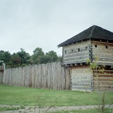
Tu-Endie-Wei State Park is a small West Virginia state park in Point Pleasant, sitting at the exact point where the Kanawha River flows into the Ohio River. At its center stands a tall granite monument, and a restored 18th-century mansion on the grounds houses a museum.

In 1774, this ground was the site of the Battle of Point Pleasant, a clash between Virginia militia and warriors led by Chief Cornstalk. The monument at the center of the park was later put up to mark that event and its role in the opening of the western frontier.

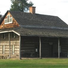
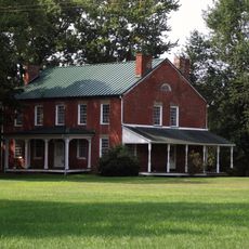
The Mansion House, built in the late 1700s, now works as a small museum filled with everyday objects from frontier life, such as tools, household items, and documents. The exhibits show how settlers and Native peoples interacted in this part of the Ohio Valley.

The park grounds are open year-round and easy to walk through in a short time, given how compact the area is. The museum inside the Mansion House has limited opening hours, so it is worth checking before planning a visit around it.

The name Tu-Endie-Wei comes from the Wyandotte language and means roughly point between two waters. It was given to the site by a Wyandotte member who attended a dedication ceremony in the 19th century, making the name itself part of the history of the place.

The community of curious travelers

AroundUs brings together thousands of curated places, local tips, and hidden gems, enriched daily by 60,000 contributors worldwide.

Start exploring
Location
Elevation above the sea
173 m
GPS coordinates
38.83920,-82.14080
Latest update
March 3, 2026 10:04
Around this place
Silver Memorial Bridge
United States of America

Silver Memorial Bridge

789 m
Fort Randolph
United States of America

Fort Randolph

1.6 km
Wood Old Homestead
United States of America

Wood Old Homestead

20.2 km
Mothman Museum
United States of America

Mothman Museum

439 m
Ravenswood Bridge
United States of America

Ravenswood Bridge

35 km
Pomeroy–Mason Bridge
United States of America

Pomeroy–Mason Bridge

21.2 km
Gen. John McCausland House
United States of America

Gen. John McCausland House

25.1 km
Ponn Humpback Covered Bridge
United States of America

Ponn Humpback Covered Bridge

30.9 km
Robert C. Byrd Lock and Dam
United States of America

Robert C. Byrd Lock and Dam

18.1 km
Racine Lock and Dam
United States of America

Racine Lock and Dam

21.8 km
Point Pleasant Rail Bridge
United States of America

Point Pleasant Rail Bridge

770 m
Meigs County Courthouse
United States of America

Meigs County Courthouse

22.9 km
Point Pleasant Historic District
United States of America

Point Pleasant Historic District

618 m
Lewis-Capehart-Roseberry House
United States of America

Lewis-Capehart-Roseberry House

4.2 km
Ravenswood "Old Town" Historic District
United States of America

Ravenswood "Old Town" Historic District

35.1 km
Gallia County Courthouse
United States of America

Gallia County Courthouse

6.3 km
The Gold Houses
United States of America

The Gold Houses

23 km
John Downing, Jr., House
United States of America

John Downing, Jr., House

20 km
Middleport Public Library
United States of America

Middleport Public Library

19.6 km
Shumaker-Lewis House
United States of America

Shumaker-Lewis House

22.2 km
Couch-Artrip House
United States of America

Couch-Artrip House

21.3 km
William H. Grant House
United States of America

William H. Grant House

19.3 km
Powell-Redmond House
United States of America

Powell-Redmond House

20.1 km
Lemley-Wood-Sayer House
United States of America

Lemley-Wood-Sayer House

35.1 km
Buffalo Town Square Historic District
United States of America

Buffalo Town Square Historic District

28.3 km
West Virginia State Farm Museum
United States of America

West Virginia State Farm Museum

10 km
Skatopia/CIA
United States of America

Skatopia/CIA

26.6 km
Old Meigs County Courthouse
United States of America

Old Meigs County Courthouse

33.6 km
Show the full map
Reviews
Share your experience

No review yet

Discussions
Start a discussion...

No discussion yet

« Tu-Endie-Wei State Park - Historical state park at river confluence in Point Pleasant, United States » is provided by Around Us (aroundus.com). Images and texts are derived from Wikimedia project under a Creative Commons license. You are allowed to copy, distribute, and modify copies of this page, under the conditions set by the license, as long as this note is clearly visible.

Discover hidden gems everywhere you go!

From secret cafés to breathtaking viewpoints, skip the crowded tourist spots and find places that match your style. Our app makes it easy with voice search, smart filtering, route optimization, and insider tips from travelers worldwide. Download now for the complete mobile experience.

Around Us App Screenshot

A unique approach to discovering new places

Le Figaro

All the places worth exploring

France Info

A tailor-made excursion in just a few clicks

20 Minutes

Around Us
Travel Guide & Maps
Download

Send to your phone

QR Code
1

Open the camera app on your mobile.

2

Point at the QR code with your camera. A notification will appear.

3

Tap the notification to open the link.