Enable Location

We need your location to show you interesting places around you

Discover nearby places

Find interesting locations and hidden gems around you

Precise directions

Get accurate directions and distances to places

Your location is never shared with other users. It's only used when you tap the location button.

Robert C. Byrd Lock and Dam

Log in to your account

Start exploring — it's free

Trusted by 62,525 travelers worldwide

Continue with Google
Continue with Apple
or

We will send you a code to connect

By continuing, you accept our Terms and Conditions and our Privacy Policy

Check your inbox

We've sent a pincode in your inbox. Please enter the code below.

Robert C. Byrd Lock and Dam

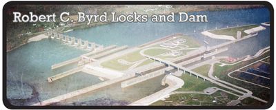
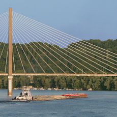
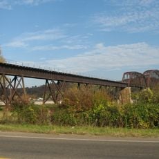
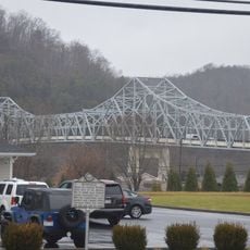
Robert C. Byrd Lock and Dam, Navigation facility on Ohio River in Mason County, United States.

The Robert C. Byrd Lock and Dam is a navigation facility on the Ohio River in Mason County. The structure contains multiple lock chambers and gates that control water flow while allowing vessels to pass through safely.

The facility was built in 1937 as a major improvement project to enhance navigation on the Ohio River. It remains a key structure for managing water flow and supporting regional commerce today.

The facility demonstrates American engineering advancement through its innovative roller gate system and strategic placement along the Ohio-West Virginia border.

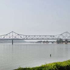
The facility sits near major highways and is visible from the riverbank, where visitors can observe the structure from several vantage points. Daytime visits work best for getting a clear view of the engineering and water management systems in action.

The structure uses a specialized roller gate system that adjusts water levels to help vessels navigate safely regardless of seasonal changes. This engineering approach solves the challenge of maintaining year-round boat traffic on rivers with natural water level fluctuations.

The community of curious travelers

AroundUs brings together thousands of curated places, local tips, and hidden gems, enriched daily by 60,000 contributors worldwide.

Start exploring
Location
GPS coordinates
38.68160,-82.19000
Latest update
December 14, 2025 11:20
Around this place
Silver Memorial Bridge
United States of America

Silver Memorial Bridge

17.4 km
Fort Randolph
United States of America

Fort Randolph

18.4 km
Tu-Endie-Wei State Park
United States of America

Tu-Endie-Wei State Park

18.1 km
Wood Old Homestead
United States of America

Wood Old Homestead

27.2 km
East Huntington Bridge
United States of America

East Huntington Bridge

32.6 km
Mothman Museum
United States of America

Mothman Museum

18.5 km
Gen. John McCausland House
United States of America

Gen. John McCausland House

19.3 km
Liggett and Myers Tobacco Company
United States of America

Liggett and Myers Tobacco Company

33.5 km
Mud River Covered Bridge
United States of America

Mud River Covered Bridge

28.2 km
Gen. Albert Gallatin Jenkins House
United States of America

Gen. Albert Gallatin Jenkins House

11.8 km
Downtown Huntington Historic District
United States of America

Downtown Huntington Historic District

33.5 km
Thomas Carroll House
United States of America

Thomas Carroll House

33.1 km
Point Pleasant Rail Bridge
United States of America

Point Pleasant Rail Bridge

18.8 km
Rotary Park Bridge
United States of America

Rotary Park Bridge

34.3 km
Point Pleasant Historic District
United States of America

Point Pleasant Historic District

18.7 km
Lewis-Capehart-Roseberry House
United States of America

Lewis-Capehart-Roseberry House

22.2 km
Putnam County Courthouse
United States of America

Putnam County Courthouse

30.7 km
Gallia County Courthouse
United States of America

Gallia County Courthouse

14.2 km
Thornburg House
United States of America

Thornburg House

31.6 km
James W. Hoge House
United States of America

James W. Hoge House

30.9 km
Barboursville Historic District
United States of America

Barboursville Historic District

31.7 km
Zachary Taylor Wellington House
United States of America

Zachary Taylor Wellington House

33.3 km
Asbury House
United States of America

Asbury House

31.3 km
Couch-Artrip House
United States of America

Couch-Artrip House

19.5 km
Scottown Covered Bridge
United States of America

Scottown Covered Bridge

22.3 km
Hurricane Splash Park
United States of America

Hurricane Splash Park

32.2 km
Winfield Toll Bridge
United States of America

Winfield Toll Bridge

30.2 km
Buffalo Town Square Historic District
United States of America

Buffalo Town Square Historic District

19.6 km
Show the full map
« Robert C. Byrd Lock and Dam - Navigation facility on Ohio River in Mason County, United States » is provided by Around Us (aroundus.com). Images and texts are derived from Wikimedia project under a Creative Commons license. You are allowed to copy, distribute, and modify copies of this page, under the conditions set by the license, as long as this note is clearly visible.

Discover hidden gems everywhere you go!

From secret cafés to breathtaking viewpoints, skip the crowded tourist spots and find places that match your style. Our app makes it easy with voice search, smart filtering, route optimization, and insider tips from travelers worldwide. Download now for the complete mobile experience.

Around Us App Screenshot

A unique approach to discovering new places

Le Figaro

All the places worth exploring

France Info

A tailor-made excursion in just a few clicks

20 Minutes

Around Us
Travel Guide & Maps
Download

Send to your phone

QR Code
1

Open the camera app on your mobile.

2

Point at the QR code with your camera. A notification will appear.

3

Tap the notification to open the link.