Enable Location

We need your location to show you interesting places around you

Discover nearby places

Find interesting locations and hidden gems around you

Precise directions

Get accurate directions and distances to places

Your location is never shared with other users. It's only used when you tap the location button.

Mud River Covered Bridge

Log in to your account

Start exploring — it's free

Trusted by 62,518 travelers worldwide

Continue with Google
Continue with Apple
or

We will send you a code to connect

By continuing, you accept our Terms and Conditions and our Privacy Policy

Check your inbox

We've sent a pincode in your inbox. Please enter the code below.

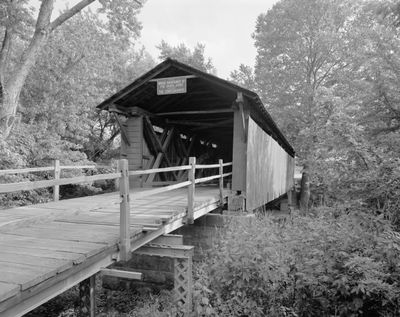
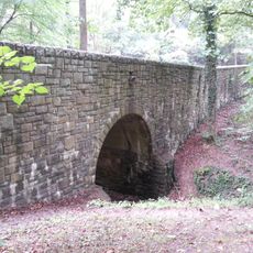
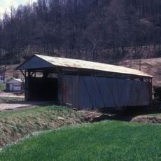
Mud River Covered Bridge, Historical covered bridge in Milton, United States.

Mud River Covered Bridge is a wooden structure with a roof that spans across the river and now stands in Pumpkin Park. The bridge has open ends where you can see the truss work inside, showing the engineering method used to make it strong and stable.

The bridge was built in 1876 when the railway was arriving in the area and Milton was starting to grow. It helped connect the developing town to surrounding areas by allowing people and wagons to cross the river.

The bridge represents how people in the 1800s solved engineering challenges with the materials they had available. Visitors can see this hands-on approach to building reflected in its wooden structure and the way it still stands.

The bridge is located in a park and is easy to reach on foot, where you can view it from all sides. Visit during the day when sunlight filters through the roof so you can see the interior structure more clearly.

This bridge was originally built to help farmers and wagons cross the river in daily work, but later it was moved to Pumpkin Park where it became part of a seasonal celebration. The relocation saved it from falling apart while giving it a new purpose for the community.

The community of curious travelers

AroundUs brings together thousands of curated places, local tips, and hidden gems, enriched daily by 60,000 contributors worldwide.

Start exploring
Location
Inception
1876
GPS coordinates
38.43094,-82.13970
Latest update
December 14, 2025 11:41
Around this place
Camden Park
United States of America

Camden Park

25.7 km
Joan C. Edwards Stadium
United States of America

Joan C. Edwards Stadium

24.5 km
Fairfield Stadium
United States of America

Fairfield Stadium

25.6 km
Huntington Museum of Art
United States of America

Huntington Museum of Art

26.1 km
Cam Henderson Center
United States of America

Cam Henderson Center

25 km
Beech Fork State Park
United States of America

Beech Fork State Park

22.6 km
Beech Fork Lake
United States of America

Beech Fork Lake

24.8 km
East Huntington Bridge
United States of America

East Huntington Bridge

21.8 km
Old Main
United States of America

Old Main

25.4 km
Ritter Park Historic District
United States of America

Ritter Park Historic District

26.2 km
Downtown Huntington Historic District
United States of America

Downtown Huntington Historic District

23.5 km
Thomas Carroll House
United States of America

Thomas Carroll House

21.8 km
Rotary Park Bridge
United States of America

Rotary Park Bridge

22.2 km
Lincoln National Bank
United States of America

Lincoln National Bank

17.5 km
Putnam County Courthouse
United States of America

Putnam County Courthouse

24.4 km
West Virginia Colored Children's Home
United States of America

West Virginia Colored Children's Home

20.5 km
Thornburg House
United States of America

Thornburg House

13.7 km
Campbell-Hicks House
United States of America

Campbell-Hicks House

26.1 km
James W. Hoge House
United States of America

James W. Hoge House

24.5 km
Barboursville Historic District
United States of America

Barboursville Historic District

13.8 km
Zachary Taylor Wellington House
United States of America

Zachary Taylor Wellington House

21.8 km
Simms School Building
United States of America

Simms School Building

25.1 km
Mortimer Place Historic District
United States of America

Mortimer Place Historic District

26.1 km
Ricketts House
United States of America

Ricketts House

23.9 km
Asbury House
United States of America

Asbury House

10.5 km
Scottown Covered Bridge
United States of America

Scottown Covered Bridge

24.7 km
Winfield Toll Bridge
United States of America

Winfield Toll Bridge

24 km
Buffalo Town Square Historic District
United States of America

Buffalo Town Square Historic District

25 km
Show the full map
« Mud River Covered Bridge - Historical covered bridge in Milton, United States » is provided by Around Us (aroundus.com). Images and texts are derived from Wikimedia project under a Creative Commons license. You are allowed to copy, distribute, and modify copies of this page, under the conditions set by the license, as long as this note is clearly visible.

Discover hidden gems everywhere you go!

From secret cafés to breathtaking viewpoints, skip the crowded tourist spots and find places that match your style. Our app makes it easy with voice search, smart filtering, route optimization, and insider tips from travelers worldwide. Download now for the complete mobile experience.

Around Us App Screenshot

A unique approach to discovering new places

Le Figaro

All the places worth exploring

France Info

A tailor-made excursion in just a few clicks

20 Minutes

Around Us
Travel Guide & Maps
Download

Send to your phone

QR Code
1

Open the camera app on your mobile.

2

Point at the QR code with your camera. A notification will appear.

3

Tap the notification to open the link.