Enable Location

We need your location to show you interesting places around you

Discover nearby places

Find interesting locations and hidden gems around you

Precise directions

Get accurate directions and distances to places

Your location is never shared with other users. It's only used when you tap the location button.

Racine Lock and Dam

Log in to your account

Start exploring — it's free

Trusted by 61,379 travelers worldwide

Continue with Google
Continue with Apple
or

We will send you a code to connect

By continuing, you accept our Terms and Conditions and our Privacy Policy

Check your inbox

We've sent a pincode in your inbox. Please enter the code below.

Racine Lock and Dam

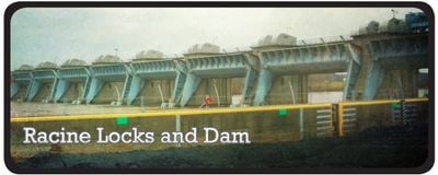
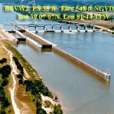
Racine Lock and Dam, Navigation infrastructure on Ohio River in Mason County, US

Description

Racine Lock and Dam is a navigation facility on the Ohio River in Mason County that helps boats pass through changes in water level. The site includes recreational areas and a reservoir where visitors can fish and enjoy outdoor activities.

History

Construction of this lock and dam system began in 1964 and was completed in 1971. The project made a significant improvement to barge traffic on this section of the Ohio River.

Culture

The facility supports the regional transportation heritage along the Ohio River, connecting to the Lewis and Clark Trail experience network.

Practical

The recreation area on the West Virginia side offers picnic tables, a playground, and fishing access during daylight hours. These public spaces are easily accessible and available for free use.

Did you know?

Eight large Tainter gates control the water levels at the site, showcasing an impressive engineering approach. A power plant operates at the facility and generates electricity for the surrounding region.

Location
GPS coordinates
38.91640,-81.91010
Latest update
December 14, 2025 13:01

AroundUs brings together thousands of curated places, local tips, and hidden gems, enriched daily by 60,000 contributors worldwide. Discover all places nearby (Mason County).

Around this place
Silver Memorial Bridge
United States of America

Silver Memorial Bridge

22.5 km
Fort Randolph
United States of America

Fort Randolph

20.3 km
Tu-Endie-Wei State Park
United States of America

Tu-Endie-Wei State Park

21.8 km
Mothman Museum
United States of America

Mothman Museum

21.4 km
Ravenswood Bridge
United States of America

Ravenswood Bridge

13.4 km
Pomeroy–Mason Bridge
United States of America

Pomeroy–Mason Bridge

15.7 km
Belleville Lock and Dam
United States of America

Belleville Lock and Dam

26.9 km
Staats Mill Covered Bridge
United States of America

Staats Mill Covered Bridge

23.6 km
Point Pleasant Rail Bridge
United States of America

Point Pleasant Rail Bridge

21.5 km
Meigs County Courthouse
United States of America

Meigs County Courthouse

16.4 km
Point Pleasant Historic District
United States of America

Point Pleasant Historic District

21.3 km
Sarvis Fork Covered Bridge
United States of America

Sarvis Fork Covered Bridge

23 km
Lewis-Capehart-Roseberry House
United States of America

Lewis-Capehart-Roseberry House

20 km
Ravenswood "Old Town" Historic District
United States of America

Ravenswood "Old Town" Historic District

13.4 km
The Gold Houses
United States of America

The Gold Houses

15.6 km
John Downing, Jr., House
United States of America

John Downing, Jr., House

15.3 km
Middleport Public Library
United States of America

Middleport Public Library

15.3 km
Shumaker-Lewis House
United States of America

Shumaker-Lewis House

15.5 km
Couch-Artrip House
United States of America

Couch-Artrip House

24.3 km
William H. Grant House
United States of America

William H. Grant House

15.7 km
Clerc-Carson House
United States of America

Clerc-Carson House

20 km
Armstrong House
United States of America

Armstrong House

20.1 km
Powell-Redmond House
United States of America

Powell-Redmond House

14.7 km
Lemley-Wood-Sayer House
United States of America

Lemley-Wood-Sayer House

13.5 km
Rankin Octagonal Barn
United States of America

Rankin Octagonal Barn

18.9 km
Ripley Historic District
United States of America

Ripley Historic District

20.4 km
West Virginia State Farm Museum
United States of America

West Virginia State Farm Museum

15.6 km
Old Meigs County Courthouse
United States of America

Old Meigs County Courthouse

19.2 km
Show the full map
« Racine Lock and Dam - Navigation infrastructure on Ohio River in Mason County, US » is provided by Around Us (aroundus.com). Images and texts are derived from Wikimedia project under a Creative Commons license. You are allowed to copy, distribute, and modify copies of this page, under the conditions set by the license, as long as this note is clearly visible.

Discover hidden gems everywhere you go!

From secret cafés to breathtaking viewpoints, skip the crowded tourist spots and find places that match your style. Our app makes it easy with voice search, smart filtering, route optimization, and insider tips from travelers worldwide. Download now for the complete mobile experience.

Around Us App Screenshot

A unique approach to discovering new places

Le Figaro

All the places worth exploring

France Info

A tailor-made excursion in just a few clicks

20 Minutes

Around Us
Travel Guide & Maps
Download

Send to your phone

QR Code
1

Open the camera app on your mobile.

2

Point at the QR code with your camera. A notification will appear.

3

Tap the notification to open the link.