Belleville Lock and Dam

Log in to your account

AroundUs is a community-driven map of interesting places, built by curious explorers like you. It grows with every review, story, and photo you share.
Connect to save your favorite spots, contribute locations, and create personalized routes.
By continuing, you accept our Terms and Conditions and our Privacy Policy

Belleville Lock and Dam

Add to collection
Map
Suggest a change
Share

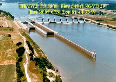
Belleville Lock and Dam, Navigation lock and hydroelectric dam on Ohio River between Meigs County, Ohio and Wood County, West Virginia, United States.

Belleville Lock and Dam is a navigation facility and dam on the Ohio River between Ohio and West Virginia. The site contains two separate locks of different sizes and an integrated power generation station.

Construction began in 1962 and was completed in 1968, establishing a permanent navigation route on the Ohio River. The project represented a major infrastructure investment for the region.

The Ohio River navigation system, including Belleville Lock and Dam, transformed local communities by establishing reliable water transportation routes for goods and materials.

Visitors can observe the lock in operation from several viewpoints along the dam and watch how vessels navigate through the system. The best viewing spots are typically along the northern shore where you have clear sightlines.

The facility generates electricity while regulating river flow, allowing the power station to serve a dual economic purpose alongside navigation. This design means the utility can produce power simultaneously with ship traffic.

Location: Meigs County

Location: Wood County

GPS coordinates: 39.11889,-81.74083

Latest update: December 14, 2025 11:04

Photos
Around this place
Blennerhassett Island Historical State Park
United States of America

Blennerhassett Island Historical State Park

19.8 km
Blennerhassett Island Bridge
United States of America

Blennerhassett Island Bridge

19.3 km
Ravenswood Bridge
United States of America

Ravenswood Bridge

20.4 km
Parkersburg–Belpre Bridge
United States of America

Parkersburg–Belpre Bridge

22.7 km
United States of America

Marie J. Desonier State Nature Preserve

17.2 km
Fort Boreman
United States of America

Fort Boreman

21.8 km
Wood County Courthouse
United States of America

Wood County Courthouse

22.3 km
W. H. Bickel Estate
United States of America

W. H. Bickel Estate

19.5 km
W.H. Smith Hardware Company Building
United States of America

W.H. Smith Hardware Company Building

22.4 km
Smoot Theatre
United States of America

Smoot Theatre

22.6 km
Captain Jonathan Stone House
United States of America

Captain Jonathan Stone House

22.1 km
Charles Rice Ames House
United States of America

Charles Rice Ames House

21.7 km
Sawyer-Curtis House
United States of America

Sawyer-Curtis House

16.3 km
Ravenswood "Old Town" Historic District
United States of America

Ravenswood "Old Town" Historic District

19.1 km
Walter Curtis House
United States of America

Walter Curtis House

11.7 km
Sharon Lodge No. 28 IOOF
United States of America

Sharon Lodge No. 28 IOOF

22.5 km
Citizens National Bank
United States of America

Citizens National Bank

22.5 km
George Neale, Jr., House
United States of America

George Neale, Jr., House

22.5 km
Trinity Episcopal Church Rectory
United States of America

Trinity Episcopal Church Rectory

22.6 km
Blackwood Covered Bridge
United States of America

Blackwood Covered Bridge

22 km
Elks Club
United States of America

Elks Club

22.7 km
Tavenner House
United States of America

Tavenner House

22.3 km
Smith Building
United States of America

Smith Building

22.4 km
Lemley-Wood-Sayer House
United States of America

Lemley-Wood-Sayer House

19 km
Rankin Octagonal Barn
United States of America

Rankin Octagonal Barn

19.7 km
Blennerhassett Museum of Regional History
United States of America

Blennerhassett Museum of Regional History

22.2 km
Old Meigs County Courthouse
United States of America

Old Meigs County Courthouse

16 km
Blennerhassett Mansion
United States of America

Blennerhassett Mansion

20.9 km
Show the full map
Reviews

Visited this place? Tap the stars to rate it and share your experience / photos with the community! Try now! You can cancel it anytime.

« Belleville Lock and Dam » is provided by Around Us (aroundus.com). Images and texts are derived from Wikimedia project under a Creative Commons license. You are allowed to copy, distribute, and modify copies of this page, under the conditions set by the license, as long as this note is clearly visible.

Discover hidden gems everywhere you go!

From secret cafés to breathtaking viewpoints, skip the crowded tourist spots and find places that match your style. Our app makes it easy with voice search, smart filtering, route optimization, and insider tips from travelers worldwide. Download now for the complete mobile experience.

Around Us App Screenshot

A unique approach to discovering new places

Le Figaro

All the places worth exploring

France Info

A tailor-made excursion in just a few clicks

20 Minutes