Enable Location

We need your location to show you interesting places around you

Discover nearby places

Find interesting locations and hidden gems around you

Precise directions

Get accurate directions and distances to places

Your location is never shared with other users. It's only used when you tap the location button.

Pomeroy–Mason Bridge

Log in to your account

Start exploring — it's free

Trusted by 61,379 travelers worldwide

Continue with Google
Continue with Apple
or

We will send you a code to connect

By continuing, you accept our Terms and Conditions and our Privacy Policy

Check your inbox

We've sent a pincode in your inbox. Please enter the code below.

Pomeroy–Mason Bridge

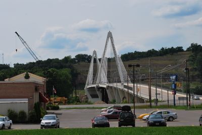
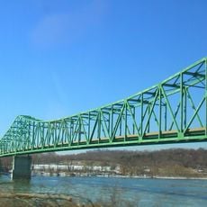
Pomeroy–Mason Bridge, Cable-stayed bridge across Ohio River between Pomeroy and Mason, United States.

Description

The Pomeroy-Mason Bridge is a modern cable-stayed structure spanning the Ohio River at the border between Ohio and West Virginia. Its sleek steel cables and concrete towers create a distinctive profile above the river valley.

History

The bridge opened in 2008 as a replacement for an older steel structure that had connected the two shores since 1928. This replacement improved traffic flow and modernized the decades-old crossing.

Culture

The bridge serves as a daily crossing point where residents from both states meet and conduct their routines together. It has become a symbol of connection for the communities on either side, shaping how people move through their shared region.

Practical

The bridge welcomes both vehicle and pedestrian traffic, making it accessible for crossing between the two states. Keep in mind this is an active traffic route, so visitors should stay alert while using it.

Did you know?

Purple lighting illuminates the bridge at night, highlighting its cable structure and creating a distinctive glow in the river valley. This lighting system makes the structure instantly recognizable to travelers moving through the area after dark.

Location
Location
Inception
December 30, 2008
Official opening
December 30, 2008
GPS coordinates
39.01330,-82.04140
Latest update
December 13, 2025 17:05

AroundUs brings together thousands of curated places, local tips, and hidden gems, enriched daily by 60,000 contributors worldwide. Discover all places nearby (West Virginia).

Around this place
Silver Memorial Bridge
United States of America

Silver Memorial Bridge

21.9 km
Fort Randolph
United States of America

Fort Randolph

20.8 km
Tu-Endie-Wei State Park
United States of America

Tu-Endie-Wei State Park

21.2 km
Mothman Museum
United States of America

Mothman Museum

20.8 km
Ravenswood Bridge
United States of America

Ravenswood Bridge

26 km
United States of America

Lake Snowden

29.1 km
Belleville Lock and Dam
United States of America

Belleville Lock and Dam

28.5 km
Ponn Humpback Covered Bridge
United States of America

Ponn Humpback Covered Bridge

29.2 km
United States of America

Marie J. Desonier State Nature Preserve

29.2 km
Racine Lock and Dam
United States of America

Racine Lock and Dam

15.7 km
Point Pleasant Rail Bridge
United States of America

Point Pleasant Rail Bridge

20.5 km
Meigs County Courthouse
United States of America

Meigs County Courthouse

1.7 km
Point Pleasant Historic District
United States of America

Point Pleasant Historic District

20.6 km
Lewis-Capehart-Roseberry House
United States of America

Lewis-Capehart-Roseberry House

17.2 km
Ravenswood "Old Town" Historic District
United States of America

Ravenswood "Old Town" Historic District

25.3 km
Gallia County Courthouse
United States of America

Gallia County Courthouse

26.7 km
Eakin Mill Covered Bridge
United States of America

Eakin Mill Covered Bridge

31 km
The Gold Houses
United States of America

The Gold Houses

1.9 km
John Downing, Jr., House
United States of America

John Downing, Jr., House

1.2 km
Blackwood Covered Bridge
United States of America

Blackwood Covered Bridge

21.3 km
Middleport Public Library
United States of America

Middleport Public Library

1.6 km
Shumaker-Lewis House
United States of America

Shumaker-Lewis House

1.1 km
William H. Grant House
United States of America

William H. Grant House

2 km
Powell-Redmond House
United States of America

Powell-Redmond House

1.3 km
Lemley-Wood-Sayer House
United States of America

Lemley-Wood-Sayer House

25.4 km
Rankin Octagonal Barn
United States of America

Rankin Octagonal Barn

30.9 km
West Virginia State Farm Museum
United States of America

West Virginia State Farm Museum

11.2 km
Skatopia/CIA
United States of America

Skatopia/CIA

11.9 km
Show the full map
« Pomeroy–Mason Bridge - Cable-stayed bridge across Ohio River between Pomeroy and Mason, United States » is provided by Around Us (aroundus.com). Images and texts are derived from Wikimedia project under a Creative Commons license. You are allowed to copy, distribute, and modify copies of this page, under the conditions set by the license, as long as this note is clearly visible.

Discover hidden gems everywhere you go!

From secret cafés to breathtaking viewpoints, skip the crowded tourist spots and find places that match your style. Our app makes it easy with voice search, smart filtering, route optimization, and insider tips from travelers worldwide. Download now for the complete mobile experience.

Around Us App Screenshot

A unique approach to discovering new places

Le Figaro

All the places worth exploring

France Info

A tailor-made excursion in just a few clicks

20 Minutes

Around Us
Travel Guide & Maps
Download

Send to your phone

QR Code
1

Open the camera app on your mobile.

2

Point at the QR code with your camera. A notification will appear.

3

Tap the notification to open the link.