Enable Location

We need your location to show you interesting places around you

Discover nearby places

Find interesting locations and hidden gems around you

Precise directions

Get accurate directions and distances to places

Your location is never shared with other users. It's only used when you tap the location button.

Dells of the Eau Claire County Park

Log in to your account

Start exploring — it's free

Trusted by 66,246 travelers worldwide

Continue with Google
Continue with Apple
or

We will send you a code to connect

By continuing, you accept our Terms and Conditions and our Privacy Policy

Check your inbox

We've sent a pincode in your inbox. Please enter the code below.

Dells of the Eau Claire County Park
Discussion Reviews 1 Photos
4.6k Popularity

Dells of the Eau Claire County Park, County park near Wausau, United States

Dells of the Eau Claire County Park is a county park in Marathon County, Wisconsin, built around a rocky gorge where the Eau Claire River runs over large boulders and forms a series of cascades. Hiking trails wind along the gorge edges and through the woods, and the site has campsites and stone shelters scattered across the area.

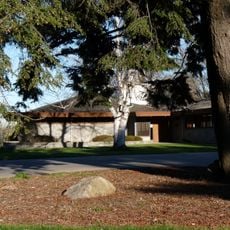
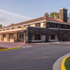
The park was created in 1923 when Marathon County acquired the land around the gorge, making it one of the county's first protected natural areas open to the public. The stone shelters and other structures were added in the 1930s by workers from the Civilian Conservation Corps.

The stone shelters in the park were built in the National Park Service rustic style, a method that uses local materials so the buildings seem to grow out of the ground around them. Walking through the gorge, visitors often find it hard to tell where the natural rock ends and the built structures begin.

The park is open year-round, but spring and summer offer the best conditions for walking the gorge trails and seeing the river at its most active. Visitors should wear sturdy shoes, especially near the water, where rock surfaces can get slippery after rain.

The boulders and rock walls lining the gorge are made of quartzite, one of the hardest rock types on Earth, formed well over a billion years ago. This hardness is why the river could not wear them down and instead carved its path around them, creating the gorge shape seen today.

The community of curious travelers

AroundUs brings together thousands of curated places, local tips, and hidden gems, enriched daily by 60,000 contributors worldwide.

Start exploring
Location
Architectural style
National Park Service rustic
GPS coordinates
45.00492,-89.34552
Latest update
March 3, 2026 08:14
Around this place
Marathon County Public Library
United States of America

Marathon County Public Library

23 km
Rib Mountain
United States of America

Rib Mountain

29.1 km
Rib Mountain State Park
United States of America

Rib Mountain State Park

28.8 km
Charles L. Manson House
United States of America

Charles L. Manson House

21.4 km
Duey and Julia Wright House
United States of America

Duey and Julia Wright House

22.7 km
Leigh Yawkey Woodson Art Museum
United States of America

Leigh Yawkey Woodson Art Museum

21.6 km
Dudley Tower
United States of America

Dudley Tower

23 km
Grand Theater
United States of America

Grand Theater

22.7 km
Marathon County Historical Museum
United States of America

Marathon County Historical Museum

22.6 km
Wausau Club
United States of America

Wausau Club

22.7 km
D. C. Everest House
United States of America

D. C. Everest House

21.5 km
United States of America

Krukowski Quarry

35.3 km
T.B. Scott Free Library
United States of America

T.B. Scott Free Library

34.1 km
Rothschild Pavilion
United States of America

Rothschild Pavilion

24.4 km
Lincoln County Courthouse
United States of America

Lincoln County Courthouse

33 km
Antigo Public Library and Deleglise Cabin
United States of America

Antigo Public Library and Deleglise Cabin

21.2 km
Antigo Opera House
United States of America

Antigo Opera House

21.1 km
Merrill City Hall
United States of America

Merrill City Hall

33.4 km
Hiram C. Stewart House
United States of America

Hiram C. Stewart House

22.4 km
First Street Bridge (Merrill, Wisconsin)
United States of America

First Street Bridge (Merrill, Wisconsin)

34.1 km
Louis Marchetti House
United States of America

Louis Marchetti House

22.6 km
C. B. Bird House
United States of America

C. B. Bird House

22.4 km
E.K. Schuetz House
United States of America

E.K. Schuetz House

21.8 km
C. F. Dunbar House
United States of America

C. F. Dunbar House

21.8 km
Ely Wright House
United States of America

Ely Wright House

22.3 km
Granville D. Jones House
United States of America

Granville D. Jones House

21.9 km
C. H. Wegner House
United States of America

C. H. Wegner House

21.9 km
Langlade County Courthouse
United States of America

Langlade County Courthouse

21.5 km
Show the full map
Reviews
Share your experience

No review yet

Discussions
Start a discussion...

No discussion yet

« Dells of the Eau Claire County Park - County park near Wausau, United States » is provided by Around Us (aroundus.com). Images and texts are derived from Wikimedia project under a Creative Commons license. You are allowed to copy, distribute, and modify copies of this page, under the conditions set by the license, as long as this note is clearly visible.

Discover hidden gems everywhere you go!

From secret cafés to breathtaking viewpoints, skip the crowded tourist spots and find places that match your style. Our app makes it easy with voice search, smart filtering, route optimization, and insider tips from travelers worldwide. Download now for the complete mobile experience.

Around Us App Screenshot

A unique approach to discovering new places

Le Figaro

All the places worth exploring

France Info

A tailor-made excursion in just a few clicks

20 Minutes

Around Us
Travel Guide & Maps
Download

Send to your phone

QR Code
1

Open the camera app on your mobile.

2

Point at the QR code with your camera. A notification will appear.

3

Tap the notification to open the link.