Chest opened
+${chestReward.xp} XP
Explorer
NOUVEAU ×${chestReward.collectible.quantity}
tapez pour fermer
Chest locked

Open chests in the app

Around Us is built for your phone — chests unlock when you walk, explore and capture nearby places.

Enable Location

We need your location to show you interesting places around you

Discover nearby places

Find interesting locations and hidden gems around you

Precise directions

Get accurate directions and distances to places

Your location is never shared with other users. It's only used when you tap the location button.

Log in to your account

Start exploring — it's free

Trusted by 72,889 travelers worldwide

Continue with Google
Continue with Apple
or

We will send you a code to connect

By continuing, you accept our Terms and Conditions and our Privacy Policy

Check your inbox

We've sent a pincode in your inbox. Please enter the code below.

Champ Clark Bridge
Discussion Reviews Photo
2.4k Popularity

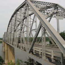
Champ Clark Bridge, Road bridge in Louisiana, Missouri, US.

The Champ Clark Bridge is a road bridge that crosses the Mississippi River, connecting Louisiana in Missouri with Pike County in Illinois. The structure uses steel girder construction and carries U.S. Route 54 traffic across the waterway.

The original bridge was built in 1928 and served for nearly a century before being replaced by a modern structure. The new bridge was constructed to meet contemporary transportation needs that the older crossing could no longer support.

The bridge bears the name of James Beauchamp Clark, who represented Missouri as Speaker of the House from 1911 to 1919 in the United States Congress.

The bridge carries two lanes of vehicle traffic as part of Route 54 and accommodates regular river crossing operations. Its wide structure ensures smooth passage for travelers moving between the two states.

A section of the original bridge collapsed during construction in 1927 due to defective temporary supports, marking an important moment in the crossing's building history. This incident influenced how engineers approached the design and safety measures for river bridge construction.

The community of curious travelers

AroundUs brings together thousands of curated places, local tips, and hidden gems, enriched daily by 60,000 contributors worldwide.

Start exploring
Official opening
August 3, 2019
GPS coordinates
39.45687,-91.04697
Latest update
December 13, 2025 11:46
Around this place
Lock and Dam No. 22
United States of America

Lock and Dam No. 22

26.5 km
Champ Clark Bridge
United States of America

Champ Clark Bridge

74 m
Lock and Dam No. 24
United States of America

Lock and Dam No. 24

14.9 km
Clarence Cannon National Wildlife Refuge
United States of America

Clarence Cannon National Wildlife Refuge

30.9 km
United States of America

Pike County Courthouse

26.7 km
North Third Street Historic District
United States of America

North Third Street Historic District

370 m
James Beauchamp Clark House
United States of America

James Beauchamp Clark House

17.8 km
Gov. Lloyd Crow Stark House and Carriage House
United States of America

Gov. Lloyd Crow Stark House and Carriage House

1.7 km
John Shastid House
United States of America

John Shastid House

26.6 km
Louisiana Public Library
United States of America

Louisiana Public Library

704 m
Bethel Chapel AME Church
United States of America

Bethel Chapel AME Church

882 m
Georgia Street Historic District
United States of America

Georgia Street Historic District

873 m
Clarksville Historic District
United States of America

Clarksville Historic District

15.6 km
Pittsfield East School
United States of America

Pittsfield East School

26.6 km
St. John's Episcopal Church
United States of America

St. John's Episcopal Church

23.3 km
Pike County Hospital
United States of America

Pike County Hospital

2.2 km
Charles Bacon House
United States of America

Charles Bacon House

1 km
Clifford-Wyrick House
United States of America

Clifford-Wyrick House

15.6 km
Turner-Pharr House
United States of America

Turner-Pharr House

15.5 km
Zoe Theatre
United States of America

Zoe Theatre

26.7 km
Capt. George and Attella Barnard House
United States of America

Capt. George and Attella Barnard House

2.2 km
United States of America

Northern Methodist Episcopal Church of Clarksville

15.8 km
Luce-Dyer House
United States of America

Luce-Dyer House

652 m
Pittsfield Historic District
United States of America

Pittsfield Historic District

26.6 km
Barry Historic District
United States of America

Barry Historic District

26.5 km
Lyman Scott House
United States of America

Lyman Scott House

14.8 km
Goodman–Stark House
United States of America

Goodman–Stark House

422 m
Meloan, Cummins & Co., General Store
United States of America

Meloan, Cummins & Co., General Store

25 km
Show the full map
Reviews
Share your experience

No review yet

Discussions
Start a discussion...

No discussion yet

« Champ Clark Bridge - Road bridge in Louisiana, Missouri, US » is provided by Around Us (aroundus.com). Images and texts are derived from Wikimedia project under a Creative Commons license. You are allowed to copy, distribute, and modify copies of this page, under the conditions set by the license, as long as this note is clearly visible.

Discover hidden gems everywhere you go!

From secret cafés to breathtaking viewpoints, skip the crowded tourist spots and find places that match your style. Our app makes it easy with voice search, smart filtering, route optimization, and insider tips from travelers worldwide. Download now for the complete mobile experience.

Around Us App Screenshot

A unique approach to discovering new places

Le Figaro

All the places worth exploring

France Info

A tailor-made excursion in just a few clicks

20 Minutes

Around Us
Travel Guide & Maps
Download

Send to your phone

QR Code
1

Open the camera app on your mobile.

2

Point at the QR code with your camera. A notification will appear.

3

Tap the notification to open the link.