Enable Location

We need your location to show you interesting places around you

Discover nearby places

Find interesting locations and hidden gems around you

Precise directions

Get accurate directions and distances to places

Your location is never shared with other users. It's only used when you tap the location button.

Clarence Cannon National Wildlife Refuge

Log in to your account

Start exploring — it's free

Trusted by 61,899 travelers worldwide

Continue with Google
Continue with Apple
or

We will send you a code to connect

By continuing, you accept our Terms and Conditions and our Privacy Policy

Check your inbox

We've sent a pincode in your inbox. Please enter the code below.

Clarence Cannon National Wildlife Refuge

Clarence Cannon National Wildlife Refuge, Wildlife refuge in Pike County, Missouri.

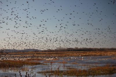
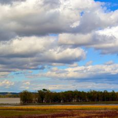
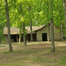
Clarence Cannon National Wildlife Refuge is a protected area on the Mississippi River floodplain, featuring open water, wet grasslands, and forested areas. The land is actively managed to maintain diverse habitats for the wildlife that lives there.

The refuge was established in 1964 by the United States Fish and Wildlife Service as a protected natural area. It was named after Congressman Clarence Cannon, who advocated for wetland protection in Missouri.

Hundreds of bird species use the refuge for breeding, resting, and feeding throughout the year. The changing seasons bring different flocks, making each visit offer fresh sightings for observers.

Access the refuge from Missouri State Highway 79 towards Annada, then head east on the county road that leads to the entrance. The best visiting season is during spring and fall migration periods when bird populations are highest.

The refuge operates a specialized hunting program designed for people with mobility and vision disabilities. This October program allows these visitors to participate in hunting using adapted methods and support.

The community of curious travelers

AroundUs brings together thousands of curated places, local tips, and hidden gems, enriched daily by 60,000 contributors worldwide.

Start exploring
Location
Inception
1964
GPS coordinates
39.26700,-90.78430
Latest update
December 14, 2025 13:05
Around this place
Koster Site
United States of America

Koster Site

21.3 km
Cuivre River State Park
United States of America

Cuivre River State Park

28.8 km
Goldenrod
United States of America

Goldenrod

16.4 km
Lock and Dam No. 25
United States of America

Lock and Dam No. 25

30.4 km
Two Rivers National Wildlife Refuge
United States of America

Two Rivers National Wildlife Refuge

29.3 km
Champ Clark Bridge
United States of America

Champ Clark Bridge

31 km
Lock and Dam No. 24
United States of America

Lock and Dam No. 24

16.2 km
Kamp Mound Site
United States of America

Kamp Mound Site

15.8 km
North Third Street Historic District
United States of America

North Third Street Historic District

30.8 km
Gov. Lloyd Crow Stark House and Carriage House
United States of America

Gov. Lloyd Crow Stark House and Carriage House

30.8 km
Louisiana Public Library
United States of America

Louisiana Public Library

30.5 km
Bethel Chapel AME Church
United States of America

Bethel Chapel AME Church

30.6 km
Georgia Street Historic District
United States of America

Georgia Street Historic District

30.5 km
Clarksville Historic District
United States of America

Clarksville Historic District

15.4 km
St. John's Episcopal Church
United States of America

St. John's Episcopal Church

19.4 km
Pike County Hospital
United States of America

Pike County Hospital

31 km
Charles Bacon House
United States of America

Charles Bacon House

30.8 km
Clifford-Wyrick House
United States of America

Clifford-Wyrick House

15.5 km
Turner-Pharr House
United States of America

Turner-Pharr House

15.6 km
Black Homestead Farm
United States of America

Black Homestead Farm

29.6 km
Schudel No. 2 Site
United States of America

Schudel No. 2 Site

13.9 km
Capt. George and Attella Barnard House
United States of America

Capt. George and Attella Barnard House

31 km
United States of America

Northern Methodist Episcopal Church of Clarksville

15.2 km
Luce-Dyer House
United States of America

Luce-Dyer House

30.6 km
Goodman–Stark House
United States of America

Goodman–Stark House

30.9 km
Meloan, Cummins & Co., General Store
United States of America

Meloan, Cummins & Co., General Store

10 km
Michael Klunk Farmstead
United States of America

Michael Klunk Farmstead

12.7 km
Cuivre River State Park Administrative Area Historic District
United States of America

Cuivre River State Park Administrative Area Historic District

31.5 km
Show the full map
« Clarence Cannon National Wildlife Refuge - Wildlife refuge in Pike County, Missouri » is provided by Around Us (aroundus.com). Images and texts are derived from Wikimedia project under a Creative Commons license. You are allowed to copy, distribute, and modify copies of this page, under the conditions set by the license, as long as this note is clearly visible.

Discover hidden gems everywhere you go!

From secret cafés to breathtaking viewpoints, skip the crowded tourist spots and find places that match your style. Our app makes it easy with voice search, smart filtering, route optimization, and insider tips from travelers worldwide. Download now for the complete mobile experience.

Around Us App Screenshot

A unique approach to discovering new places

Le Figaro

All the places worth exploring

France Info

A tailor-made excursion in just a few clicks

20 Minutes

Around Us
Travel Guide & Maps
Download

Send to your phone

QR Code
1

Open the camera app on your mobile.

2

Point at the QR code with your camera. A notification will appear.

3

Tap the notification to open the link.