Two Rivers National Wildlife Refuge

Log in to your account

AroundUs is a community-driven map of interesting places, built by curious explorers like you. It grows with every review, story, and photo you share.
Connect to save your favorite spots, contribute locations, and create personalized routes.
Continue with Google
Continue with Apple
Continue with X
Continue with Facebook
Continue with email
By continuing, you accept our Terms and Conditions and our Privacy Policy
Create an account

Two Rivers National Wildlife Refuge

Add to collection
Map
Suggest a change
Share

Two Rivers National Wildlife Refuge, National Wildlife Refuge at Mississippi and Illinois Rivers confluence, Illinois

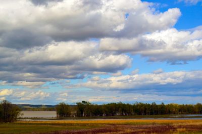
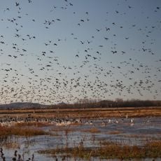
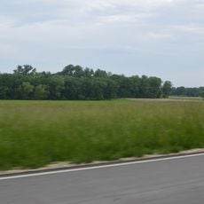
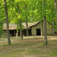
Two Rivers National Wildlife Refuge is a protected area of wetlands, bottomland forests, and prairies situated where the Mississippi and Illinois Rivers meet in Calhoun County. The refuge covers roughly 9,000 acres and provides habitat for numerous bird, fish, and mammal species.

The refuge was established to protect the valuable wetlands and bottomland forests at the meeting point of these two major rivers. Within the Duncan Farm area of the Gilbert Lake Division sits an American Indian mound that marks the location of past settlements in the region.

The refuge runs environmental education programs throughout the year that teach visitors about wildlife protection and how natural systems work. These initiatives help people connect with the importance of preserving the land.

The refuge headquarters can be found by traveling west from Alton along the Great River Road toward Brussels Ferry, followed by a short drive to the main entrance. Visitors should come prepared for varied weather and wear sturdy shoes since much of the terrain is wet or muddy.

The refuge is home to a population of decurrent false aster, a federally threatened plant species that thrives in the specific conditions of this riverine setting. This rare plant is often overlooked by visitors but makes the location particularly valuable for botanists and conservation experts.

Location: Illinois

Inception: 1958

Website: https://fws.gov/refuge/two_rivers

GPS coordinates: 39.04170,-90.60830

Latest update: December 12, 2025 14:26

Photos
Around this place
Katy Trail State Park
United States of America

Katy Trail State Park

28.5 km
United States of America

Mid Rivers Mall

27.4 km
Koster Site
United States of America

Koster Site

19.3 km
Cuivre River State Park
United States of America

Cuivre River State Park

28.1 km
United States of America

Fort Zumwalt Park

28.6 km
Lock and Dam No. 25
United States of America

Lock and Dam No. 25

7.9 km
Clarence Cannon National Wildlife Refuge
United States of America

Clarence Cannon National Wildlife Refuge

29.3 km
St. Mary's Institute of O'Fallon
United States of America

St. Mary's Institute of O'Fallon

26.7 km
Golden Eagle-Toppmeyer Site
United States of America

Golden Eagle-Toppmeyer Site

16 km
Hamilton Primary School
United States of America

Hamilton Primary School

18.3 km
Principia College Historic District
United States of America

Principia College Historic District

24.8 km
Duncan Farm
United States of America

Duncan Farm

11.6 km
Old Rock House
United States of America

Old Rock House

28.4 km
Jersey County Courthouse
United States of America

Jersey County Courthouse

25.6 km
Elsah Historic District
United States of America

Elsah Historic District

23.6 km
Paris Mason Building
United States of America

Paris Mason Building

15.7 km
Charles Brainerd House
United States of America

Charles Brainerd House

17.3 km
Smith-Duncan House and Eastman Barn
United States of America

Smith-Duncan House and Eastman Barn

11.6 km
Samuel Stewart Watson House
United States of America

Samuel Stewart Watson House

29 km
Slaten-LaMarsh House
United States of America

Slaten-LaMarsh House

17.1 km
Schudel No. 2 Site
United States of America

Schudel No. 2 Site

15.4 km
Jerseyville Downtown Historic District
United States of America

Jerseyville Downtown Historic District

25.7 km
Brussels Historic District
United States of America

Brussels Historic District

10.4 km
Grafton Historic District
United States of America

Grafton Historic District

17.3 km
Grafton Bank
United States of America

Grafton Bank

17.2 km
John and Amelia McClintock House
United States of America

John and Amelia McClintock House

17.4 km
Michael Klunk Farmstead
United States of America

Michael Klunk Farmstead

24 km
Cuivre River State Park Administrative Area Historic District
United States of America

Cuivre River State Park Administrative Area Historic District

27.8 km
Show the full map
Reviews

Visited this place? Tap the stars to rate it and share your experience / photos with the community! Try now! You can cancel it anytime.

« Two Rivers National Wildlife Refuge - National Wildlife Refuge at Mississippi and Illinois Rivers confluence, Illinois » is provided by Around Us (aroundus.com). Images and texts are derived from Wikimedia project under a Creative Commons license. You are allowed to copy, distribute, and modify copies of this page, under the conditions set by the license, as long as this note is clearly visible.

Discover hidden gems everywhere you go!

From secret cafés to breathtaking viewpoints, skip the crowded tourist spots and find places that match your style. Our app makes it easy with voice search, smart filtering, route optimization, and insider tips from travelers worldwide. Download now for the complete mobile experience.

Around Us App Screenshot

A unique approach to discovering new places

Le Figaro

All the places worth exploring

France Info

A tailor-made excursion in just a few clicks

20 Minutes