Kamp Mound Site

Log in to your account

AroundUs is a community-driven map of interesting places, built by curious explorers like you. It grows with every review, story, and photo you share.
Connect to save your favorite spots, contribute locations, and create personalized routes.
Continue with Google
Continue with Apple
Continue with X
Continue with Facebook
Continue with email
By continuing, you accept our Terms and Conditions and our Privacy Policy
Create an account
Add to collection
Map
Suggest a change
Share

Kamp Mound Site, Archaeological mound complex in Calhoun County, United States.

Kamp Mound Site is a prehistoric earthwork complex with seven mounds positioned along the Illinois River north of Kampsville. The mounds and associated village settlement occupy a large area near Illinois Route 100 and contain layers of soil revealing occupation spans of several centuries.

Village habitation began around 450 AD and continued to 700 AD, while the mounds themselves were built earlier by the Havana Hopewell culture between 100 BC and 450 AD. This timeline reveals how different groups used and modified this location over several centuries.

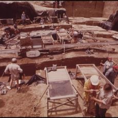
The site reveals evidence of ceremonial practices and burial rituals that show how early inhabitants honored their dead and gathered as a community. Artifacts found here suggest this place held special meaning for people across a wider region.

The site is a protected location for archaeological study, allowing visitors to see different settlement phases on the landscape. Plan your visit during dry weather when trails and mound approaches are easiest to navigate safely.

Excavations have uncovered shell fragments and animal bones that reveal what foods early inhabitants ate and how they obtained them. These remains also hint at trade connections, since some materials came from distant sources.

Location: Calhoun County

GPS coordinates: 39.33220,-90.62080

Latest update: December 14, 2025 14:45

Photos
Around this place
Koster Site
United States of America

Koster Site

15.1 km
Goldenrod
United States of America

Goldenrod

971 m
Two Rivers National Wildlife Refuge
United States of America

Two Rivers National Wildlife Refuge

32.4 km
Lock and Dam No. 24
United States of America

Lock and Dam No. 24

25.2 km
Clarence Cannon National Wildlife Refuge
United States of America

Clarence Cannon National Wildlife Refuge

15.8 km
United States of America

Pike County Courthouse

34.5 km
John Shastid House
United States of America

John Shastid House

34.8 km
Clarksville Historic District
United States of America

Clarksville Historic District

24.8 km
Jersey County Courthouse
United States of America

Jersey County Courthouse

34.6 km
Pittsfield East School
United States of America

Pittsfield East School

34.8 km
Winchester Historic District
United States of America

Winchester Historic District

36 km
St. John's Episcopal Church
United States of America

St. John's Episcopal Church

34.6 km
Clifford-Wyrick House
United States of America

Clifford-Wyrick House

24.8 km
Turner-Pharr House
United States of America

Turner-Pharr House

25 km
Zoe Theatre
United States of America

Zoe Theatre

34.6 km
Hodges House
United States of America

Hodges House

18.7 km
Scott County Courthouse
United States of America

Scott County Courthouse

36 km
Carrollton Courthouse Square Historic District
United States of America

Carrollton Courthouse Square Historic District

18.7 km
Jerseyville Downtown Historic District
United States of America

Jerseyville Downtown Historic District

34.7 km
Schudel No. 2 Site
United States of America

Schudel No. 2 Site

19.8 km
Black Homestead Farm
United States of America

Black Homestead Farm

16 km
United States of America

Northern Methodist Episcopal Church of Clarksville

24.7 km
Pittsfield Historic District
United States of America

Pittsfield Historic District

34.8 km
Lyman Scott House
United States of America

Lyman Scott House

35 km
United States of America

Virginia Tillery Round Barn

19.4 km
White Hall Historic District
United States of America

White Hall Historic District

22 km
Meloan, Cummins & Co., General Store
United States of America

Meloan, Cummins & Co., General Store

25.3 km
Michael Klunk Farmstead
United States of America

Michael Klunk Farmstead

8.6 km
Show the full map
Reviews

Visited this place? Tap the stars to rate it and share your experience / photos with the community! Try now! You can cancel it anytime.

« Kamp Mound Site - Archaeological mound complex in Calhoun County, United States » is provided by Around Us (aroundus.com). Images and texts are derived from Wikimedia project under a Creative Commons license. You are allowed to copy, distribute, and modify copies of this page, under the conditions set by the license, as long as this note is clearly visible.

Discover hidden gems everywhere you go!

From secret cafés to breathtaking viewpoints, skip the crowded tourist spots and find places that match your style. Our app makes it easy with voice search, smart filtering, route optimization, and insider tips from travelers worldwide. Download now for the complete mobile experience.

Around Us App Screenshot

A unique approach to discovering new places

Le Figaro

All the places worth exploring

France Info

A tailor-made excursion in just a few clicks

20 Minutes