Enable Location

We need your location to show you interesting places around you

Discover nearby places

Find interesting locations and hidden gems around you

Precise directions

Get accurate directions and distances to places

Your location is never shared with other users. It's only used when you tap the location button.

Log in to your account

Start exploring — it's free

Trusted by 62,937 travelers worldwide

Continue with Google
Continue with Apple
or

We will send you a code to connect

By continuing, you accept our Terms and Conditions and our Privacy Policy

Check your inbox

We've sent a pincode in your inbox. Please enter the code below.

The Big Fish
Discussion Reviews Photo
2.7k Popularity

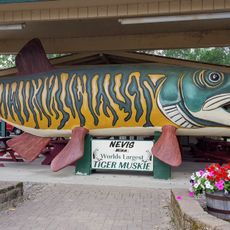
The Big Fish, Roadside attraction in Bena, Minnesota, US

The Big Fish is a 65-foot-long wooden muskie structure positioned along U.S. Highway 2 in Bena, painted olive green with distinctive red eyes created from Coca-Cola signs. Inside, exposed wooden framing resembles curved fish ribs, forming an anatomically-inspired interior that extends the playful design throughout the entire structure.

Built in 1958 as the Big Muskie Drive-In restaurant, this structure originally functioned with an interior lunch counter that served hamburgers and ice cream through a window. Over the decades, the building transitioned from a working restaurant into a recognized symbol of American roadside heritage.

This wooden structure represents a distinctive American tradition of celebrating local themes through outsized roadside monuments. It reflects how travelers and communities have long marked highways with playful landmarks that draw visitors off main routes.

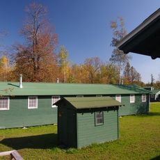
The Big Fish is accessible year-round and located near Lake Winnibigoshish, making it easy to stop for photographs. An adjacent supper club serves food and beverages if you want to stay longer and take a break.

The eyes of the structure are made from recycled Coca-Cola signs, connecting this roadside landmark to classic advertising traditions of its era. This repurposed element adds a layer of historical charm and shows how even small details were thoughtfully incorporated into the design.

The community of curious travelers

AroundUs brings together thousands of curated places, local tips, and hidden gems, enriched daily by 60,000 contributors worldwide.

Start exploring
GPS coordinates
47.35162,-94.26663
Latest update
December 8, 2025 21:06
Around this place
Paul Bunyan and Babe the Blue Ox
United States of America

Paul Bunyan and Babe the Blue Ox

48 km
Lake Winnibigoshish
United States of America

Lake Winnibigoshish

12.7 km
Lake Bemidji State Park
United States of America

Lake Bemidji State Park

46.6 km
Waldsee
United States of America

Waldsee

42.4 km
Rabideau CCC Camp
United States of America

Rabideau CCC Camp

38.5 km
Forest History Center
United States of America

Forest History Center

54.6 km
Schoolcraft State Park
United States of America

Schoolcraft State Park

38 km
Paul Bunyan State Forest
United States of America

Paul Bunyan State Forest

60.5 km
Bowstring State Forest
United States of America

Bowstring State Forest

15.1 km
Nevis Tiger Muskie
United States of America

Nevis Tiger Muskie

61.3 km
Bemidji Carnegie Library
United States of America

Bemidji Carnegie Library

48.1 km
Beltrami County Courthouse
United States of America

Beltrami County Courthouse

48.3 km
Nymore Bridge
United States of America

Nymore Bridge

47.8 km
Marcell Ranger Station
United States of America

Marcell Ranger Station

51.4 km
David Park House
United States of America

David Park House

48.2 km
Remer State Forest
United States of America

Remer State Forest

41 km
Lake Bemidji State Park CCC/NYA/Rustic Style Historic Resources
United States of America

Lake Bemidji State Park CCC/NYA/Rustic Style Historic Resources

46.8 km
Sandtrap Golf Course
United States of America

Sandtrap Golf Course

27.2 km
Draper Lookout Tower
United States of America

Draper Lookout Tower

54 km
Schoolcraft Fire Tower
United States of America

Schoolcraft Fire Tower

54.5 km
Cuba Hill Lookout Tower
United States of America

Cuba Hill Lookout Tower

16.8 km
Rabideau Civilian Conservation Corps Camp Picnic Shelter
United States of America

Rabideau Civilian Conservation Corps Camp Picnic Shelter

38.6 km
Blackduck Lookout Tower
United States of America

Blackduck Lookout Tower

43.1 km
Farley Hill Lookout Tower
United States of America

Farley Hill Lookout Tower

26.7 km
Pinewood Fire Tower
United States of America

Pinewood Fire Tower

51.8 km
Kabekona Lookout Tower
United States of America

Kabekona Lookout Tower

48.5 km
Coleraine Fire Lookout Tower
United States of America

Coleraine Fire Lookout Tower

62.2 km
Ruby Lake Camp
United States of America

Ruby Lake Camp

57.2 km
Show the full map
Reviews
Share your experience

No review yet

Discussions
Start a discussion...

No discussion yet

« The Big Fish - Roadside attraction in Bena, Minnesota, US » is provided by Around Us (aroundus.com). Images and texts are derived from Wikimedia project under a Creative Commons license. You are allowed to copy, distribute, and modify copies of this page, under the conditions set by the license, as long as this note is clearly visible.

Discover hidden gems everywhere you go!

From secret cafés to breathtaking viewpoints, skip the crowded tourist spots and find places that match your style. Our app makes it easy with voice search, smart filtering, route optimization, and insider tips from travelers worldwide. Download now for the complete mobile experience.

Around Us App Screenshot

A unique approach to discovering new places

Le Figaro

All the places worth exploring

France Info

A tailor-made excursion in just a few clicks

20 Minutes

Around Us
Travel Guide & Maps
Download

Send to your phone

QR Code
1

Open the camera app on your mobile.

2

Point at the QR code with your camera. A notification will appear.

3

Tap the notification to open the link.