Helsby hill fort, Iron Age promontory fort in Helsby, England
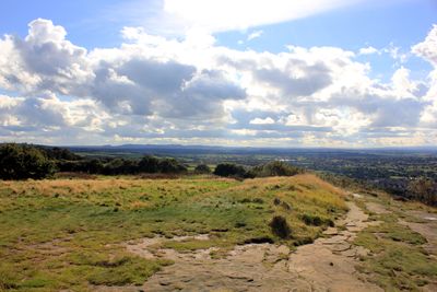
Helsby hill fort is an Iron Age fort built on a hilltop rising about 141 meters above the surrounding plain, with steep cliffs forming natural defenses on its northern and western sides. Double rampart earthworks extend across the southern approach, where the terrain slopes gradually downward.
The fort was built during the Iron Age by local communities who took advantage of the natural height and cliff faces as primary defenses. Excavation work revealed that the ramparts were constructed from sand, rubble, and stones set in a specific pattern to create a stable defensive structure.
The name derives from Old English and refers to the hill's elevated position in the landscape. Visitors can still sense the strategic advantage this location provided for those who built and lived here.
The site is freely accessible year-round and is maintained by the National Trust, though visitors should wear sturdy shoes as the slopes are steep and paths can be uneven. The exposed location at the top means weather conditions can change quickly, so checking conditions before a visit is wise.
An old local saying claims that rain will persist as long as clouds hang over the hilltop. This piece of folklore has endured in the region and reflects how exposed this location is to passing weather systems.
The community of curious travelers
AroundUs brings together thousands of curated places, local tips, and hidden gems, enriched daily by 60,000 contributors worldwide.