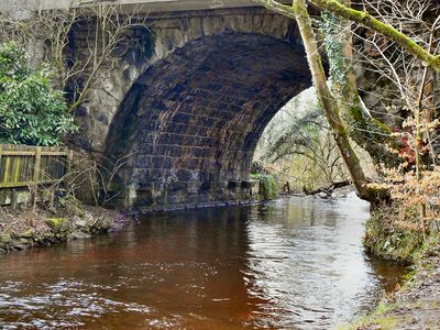
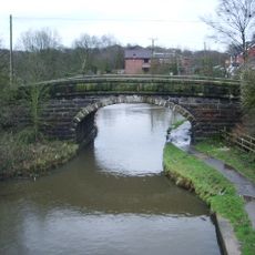
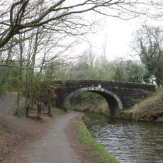
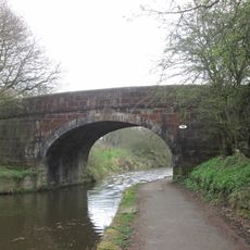
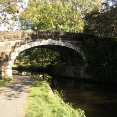
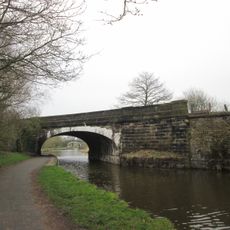
Yarrow Bridge, Road bridge in Chorley, England
Yarrow Bridge is a stone arch bridge spanning the River Yarrow with a single wide opening and detailed stonework throughout its construction. The structure carries traffic across the water using its curved arch design to support the roadway above.
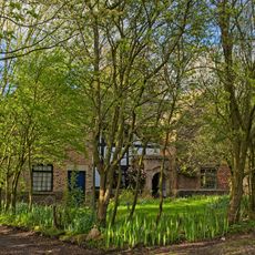
The bridge dates to the late 17th century when the A6 road to Bolton was redirected eastward away from Duxbury Woods. This road change required new crossing points across the river.
The construction shows traditional British bridge-building methods, with thin stones forming the arch and square stones creating the cornice details. The careful stonework demonstrates the craftsmanship of its makers.
The bridge carries the busy A6 road and can be crowded during peak traffic hours. Visitors should stand carefully at the sides and watch for moving vehicles.
At the point where the Yarrow River and Black Brook meet, the bridge offers views of where two waterways come together. A smaller bridge carrying Hoggs Lane sits nearby, showing the importance of this crossing point in local travel routes.
GPS coordinates: 53.64100,-2.61900
Latest update: December 14, 2025 17:41
Yarrow Valley Park
1.5 km
Duxbury Hall
1.2 km
St Laurence's Church, Chorley
1.8 km
St George's Church, Chorley
1.4 km
Chorley Town Hall
1.7 km
Former Gateway To St Laurences Churchyard
1.8 km
Park House Wesley House
2 km
Canal Bridge Number 76
1.2 km
Canal Bridge Number 74 At Sd 595 156 Winstanley Bridge
724 m
War Memorial Gateway to Astley Park
1.9 km
5, Park Street
2 km
12 And 14, Park Road
2 km
The Swan With Two Necks
1.8 km
All Saints Church, Chorley
1.5 km
Canal Bridge Number 72 At Sd 596 146 Idle Bridge
1.7 km
Chorley Library
1.5 km
Canal Bridge Number 73
993 m
The George
1.7 km
Gateway To Roman Catholic Church Of St Mary
1.6 km
Chorley Little Theatre
1.7 km
Lower Burgh Hall
2.1 km
Canal Bridge Number 75 At Sd 595 163
419 m
Milepost 350 Metres South East Of Junction Of Wigan Lane And Rawlinson Lane
1.7 km
Post And Railings Protecting Raised Section Of Park Road On East Side, Extending Circa 80 Metres From Junction With Church Brow
1.8 km
Leeds Liverpool Canal, Railway Bridge Over Leeds Liverpool Canal At Sd 595 162
360 m
The Manor House
1.7 km
Hall O' Th' Hill
1.7 km
Milestone, Heath Charnock, nr Adlington
1.5 kmVisited this place? Tap the stars to rate it and share your experience / photos with the community! Try now! You can cancel it anytime.
Discover hidden gems everywhere you go!
From secret cafés to breathtaking viewpoints, skip the crowded tourist spots and find places that match your style. Our app makes it easy with voice search, smart filtering, route optimization, and insider tips from travelers worldwide. Download now for the complete mobile experience.
A unique approach to discovering new places❞
— Le Figaro
All the places worth exploring❞
— France Info
A tailor-made excursion in just a few clicks❞
— 20 Minutes