High Carlbury Farmhouse, farmhouse in High Coniscliffe, Darlington, County Durham, UK
Location: High Coniscliffe
GPS coordinates: 54.55179,-1.67205
Latest update: November 16, 2025 09:25
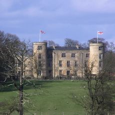
Walworth Castle
1.6 km
Piercebridge Roman Fort
1.7 km
Piercebridge Roman Bridge
1.8 km
Ulnaby
1.5 km
Piercebridge Roman Fort
1.8 km
Church of St Mary
1.7 km
Carlbury Bridge
1.6 km
Ivy House
1.6 km
Milepost South Of Carlbury Hall
1.7 km
Milepost 700 Metres South East Of Junction With New Lane
1 km
Wall With Two Light Traceried Window 40 Metres West Of Carlbury Hall
1.6 km
Deserted medieval village of Ulnaby
1.4 km
Garden Walls, Farmbuilding And Smithy To North And East Of Ulnaby Hall
1.4 km
28, The Green
1.7 km
Wall, Gate Piers, Overthrow And Lantern To West Of Church Of St Mary
1.7 km
Thompson Headstone 25 Metres South Of Church Of St Mary
1.5 km
Stone Coffin Against South Nave Wall Of Church Of St Mary
1.6 km
2, The Green
1.6 km
Smotherlaw round barrow
1.5 km
Front Range Of Farmbuildings And Gin Gang To West Of Piercebridge Grange Farmhouse
1.1 km
Piercebridge Grange Farmhouse And Front Garden Wall, Railings And Gate
1.1 km
Hall Headstone 20 Metres South Of Church Of St Mary
1.5 km
Garden Walls In Front Of Ulnaby Hall
1.4 km
Ulnaby Hall
1.4 km
1 and 2, Carlbury Vale
1.7 km
29, The Green
1.7 km
Denton Hall
1.6 km
Glebe House
1.5 kmReviews
Visited this place? Tap the stars to rate it and share your experience / photos with the community! Try now! You can cancel it anytime.
Discover hidden gems everywhere you go!
From secret cafés to breathtaking viewpoints, skip the crowded tourist spots and find places that match your style. Our app makes it easy with voice search, smart filtering, route optimization, and insider tips from travelers worldwide. Download now for the complete mobile experience.

A unique approach to discovering new places❞
— Le Figaro
All the places worth exploring❞
— France Info
A tailor-made excursion in just a few clicks❞
— 20 Minutes