Dandrymire Viaduct

Log in to your account

AroundUs is a community-driven map of interesting places, built by curious explorers like you. It grows with every review, story, and photo you share.
Connect to save your favorite spots, contribute locations, and create personalized routes.
Continue with Google
Continue with Apple
Continue with X
Continue with Facebook
Continue with email
By continuing, you accept our Terms and Conditions and our Privacy Policy
Create an account
Add to collection
Map
Suggest a change
Share

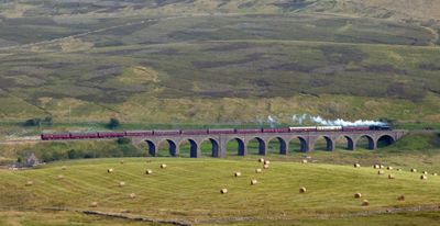
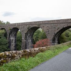
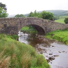
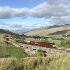
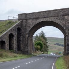
Dandrymire Viaduct, Railway viaduct in Garsdale, United Kingdom.

Dandrymire Viaduct is a sandstone railway bridge at Garsdale featuring twelve curved stone arches spanning the moorland. The structure rises above the ground and forms a key element of the Settle-Carlisle rail line through the Yorkshire Dales.

Builders first attempted to construct an embankment from earth in 1869, but the boggy ground consumed vast quantities of fill material. They switched to building a viaduct instead, which was completed between 1873 and 1875 to overcome the unstable terrain.

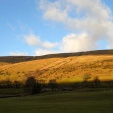
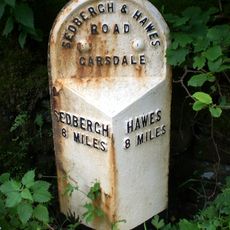
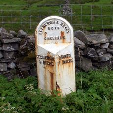
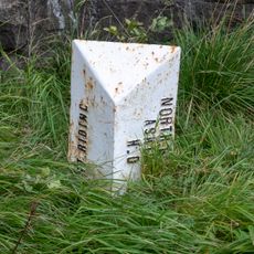
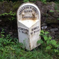
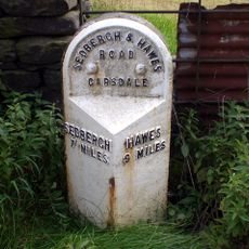
This railway line is part of the Settle-Carlisle route, a key passage through the northern dales that connected remote communities. Locals and travelers have long seen it as a symbol of Victorian ambition to reach the distant regions of Yorkshire.

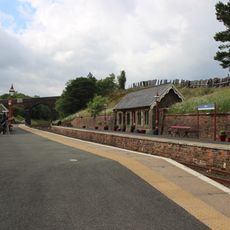
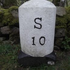
The viaduct sits northeast of Garsdale Station and is best viewed from nearby walking paths across the moorland. Visit during clearer weather to appreciate the full scale of the structure and the surrounding landscape without mist or rain obscuring the views.

During construction, roughly 19,000 cubic meters of earth disappeared into the bog before engineers abandoned the embankment approach entirely. This failure led to an ingenious solution that became a landmark of Victorian problem-solving in difficult terrain.

Location: Garsdale

GPS coordinates: 54.32605,-2.31933

Latest update: December 14, 2025 11:01

Photos
Around this place
Cotter Force
United Kingdom

Cotter Force

5.7 km
Baugh Fell
United Kingdom

Baugh Fell

5.3 km
Great Knoutberry Hill
United Kingdom

Great Knoutberry Hill

5.2 km
St John the Evangelist's Church, Cowgill
United Kingdom

St John the Evangelist's Church, Cowgill

6.5 km
Church of St John the Baptist
United Kingdom

Church of St John the Baptist

5.5 km
Bridge Over Cotterdale Beck
United Kingdom

Bridge Over Cotterdale Beck

4.1 km
Sportsmans Inn
United Kingdom

Sportsmans Inn

6.5 km
Appersett Viaduct
United Kingdom

Appersett Viaduct

6.6 km
Widdale Bridge
United Kingdom

Widdale Bridge

5.5 km
Dandra Garth
United Kingdom

Dandra Garth

4.8 km
Hell Gill Bridge
United Kingdom

Hell Gill Bridge

4.6 km
Garsdale Milestone Immediately East Of Boundary Marker
United Kingdom

Garsdale Milestone Immediately East Of Boundary Marker

242 m
Ais Gill Viaduct
United Kingdom

Ais Gill Viaduct

5.6 km
East Rackenthwaite And Adjoining Barn
United Kingdom

East Rackenthwaite And Adjoining Barn

6.4 km
Passenger Waiting Room On East Side Of Railway Track At Dent Station
United Kingdom

Passenger Waiting Room On East Side Of Railway Track At Dent Station

5.6 km
Garsdale Signal Box
United Kingdom

Garsdale Signal Box

661 m
Rigg House West
United Kingdom

Rigg House West

5.2 km
Milestone (Sedbergh 8) Approximately 5 Metres East Of Scar Foot Bridge
United Kingdom

Milestone (Sedbergh 8) Approximately 5 Metres East Of Scar Foot Bridge

2.7 km
Milestone (Sedbergh 9) Approximately 250 Metres East Of Harding Bridge (Not Included)
United Kingdom

Milestone (Sedbergh 9) Approximately 250 Metres East Of Harding Bridge (Not Included)

1.2 km
Moorcock Road railway bridge
United Kingdom

Moorcock Road railway bridge

235 m
Milestone (Sedbergh 10) Approximately 120 Metres South East Of Sportsmans Inn
United Kingdom

Milestone (Sedbergh 10) Approximately 120 Metres South East Of Sportsmans Inn

6.5 km
Garsdale Boundary Marker At Country Boundary Of North Yorkshire And Cumbria
United Kingdom

Garsdale Boundary Marker At Country Boundary Of North Yorkshire And Cumbria

232 m
Milestone (Sedbergh 9) On South Side Of Road Approximately 50 Metres South West Of Cowgill Bridge
United Kingdom

Milestone (Sedbergh 9) On South Side Of Road Approximately 50 Metres South West Of Cowgill Bridge

6.6 km
Milestone (Sedbergh 6) Approximately 75 Metres West Of Kirk Bridge
United Kingdom

Milestone (Sedbergh 6) Approximately 75 Metres West Of Kirk Bridge

5.6 km
Milestone (Sedbergh 7) Approximately 10 Metres West Of East Little Town
United Kingdom

Milestone (Sedbergh 7) Approximately 10 Metres West Of East Little Town

4.3 km
Rigg House
United Kingdom

Rigg House

5.3 km
Milestone, S of bridge over Snaizeholme Beck & track to Widdale Side opposite
United Kingdom

Milestone, S of bridge over Snaizeholme Beck & track to Widdale Side opposite

5.6 km
Milestone, ½ mile N of Moorcock Inn
United Kingdom

Milestone, ½ mile N of Moorcock Inn

981 m
Show the full map
Reviews

Visited this place? Tap the stars to rate it and share your experience / photos with the community! Try now! You can cancel it anytime.

« Dandrymire Viaduct - Railway viaduct in Garsdale, United Kingdom » is provided by Around Us (aroundus.com). Images and texts are derived from Wikimedia project under a Creative Commons license. You are allowed to copy, distribute, and modify copies of this page, under the conditions set by the license, as long as this note is clearly visible.

Discover hidden gems everywhere you go!

From secret cafés to breathtaking viewpoints, skip the crowded tourist spots and find places that match your style. Our app makes it easy with voice search, smart filtering, route optimization, and insider tips from travelers worldwide. Download now for the complete mobile experience.

Around Us App Screenshot

A unique approach to discovering new places

Le Figaro

All the places worth exploring

France Info

A tailor-made excursion in just a few clicks

20 Minutes