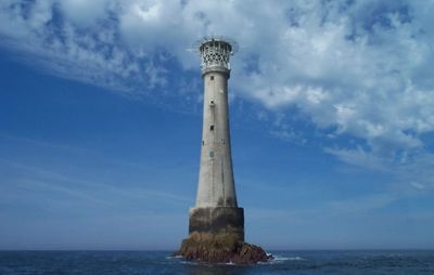
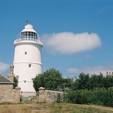
Bishop Rock Lighthouse, Maritime navigation lighthouse in Isles of Scilly, England.
Bishop Rock Lighthouse is a 49-meter granite tower built on a small rocky platform in the Atlantic, marking the westernmost point of the Isles of Scilly. The structure features solid stone construction designed to withstand the constant force of ocean waves.
A first lighthouse was attempted in 1847 but storms quickly destroyed it. Engineer James Walker completed the current stronger stone structure in 1858.
The structure symbolizes British maritime heritage and the commitment to protecting seafarers in one of the country's most isolated regions. From the islands, visitors can observe how this building represents the determination to maintain navigation safety in a perilous location.
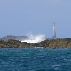
The building is visible from outside when visiting the islands, but viewing from a distance is common because direct access is limited. Best observation happens during clear weather when the structure stands out clearly.
This structure endures some of the strongest wave impacts of any lighthouse in the world, with ocean spray reaching impressive heights. This shows the extreme conditions the building faces every day.
Location: Isles of Scilly
Inception: 1858
Architects: James Nicholas Douglass, James Walker
Height: 49 m
Made from material: granite
Part of: Isles of Scilly
GPS coordinates: 49.87167,-6.44500
Latest update: December 12, 2025 17:41
Western Rocks
3.1 km
Star Castle
10.1 km
St Agnes' Church
7.2 km
Wingletang Down
7.7 km
St Agnes Lighthouse
7.5 km
Garrison Tower
9.9 km
Obadiah's Barrow
8.3 km
Bible Christian Chapel, St Agnes
7.4 km
Old Man of Gugh
8.6 km
Star Castle
10.1 km
Seal Rock
9.1 km
Late 19th-early 20th century Woolpack Battery on The Garrison, St Mary's
9.8 km
K6 Telephone Kiosk
7.6 km
Newman House
10.2 km
St Agnes WWI Memorial Cross, Isles of Scilly
7.3 km
Post-medieval breastwork, curtain wall and associated defensive structures on the periphery of The Garrison, St Mary's
9.8 km
Two early post-medieval quays in north and north western Periglis, St Agnes
7.2 km
St Warna's Well, St Agnes
7.4 km
Prehistoric linear boundary on Dropnose Point, Gugh
8.7 km
Prehistoric cairns, entrance graves, field system and settlements and post-medieval kelp pits on Kittern Hill, Gugh
8.4 km
The Old Man prehistoric standing stone, Gugh
8.6 km
Prehistoric linear boundary on Puffin Island
10.3 km
Entrance Grave, Samson
9.3 km
Woolpack Battery
9.7 km
Building To South East Of The Lighthouse
7.5 km
Nineteenth century gig-shed north east of Porth Askin
7.6 km
Outbuilding At Sv 8831 0819
7.8 km
Prehistoric field system, settlement and cairn east of Barnaby Lane, St Agnes
7.7 kmVisited this place? Tap the stars to rate it and share your experience / photos with the community! Try now! You can cancel it anytime.
Discover hidden gems everywhere you go!
From secret cafés to breathtaking viewpoints, skip the crowded tourist spots and find places that match your style. Our app makes it easy with voice search, smart filtering, route optimization, and insider tips from travelers worldwide. Download now for the complete mobile experience.
A unique approach to discovering new places❞
— Le Figaro
All the places worth exploring❞
— France Info
A tailor-made excursion in just a few clicks❞
— 20 Minutes