Enable Location

We need your location to show you interesting places around you

Discover nearby places

Find interesting locations and hidden gems around you

Precise directions

Get accurate directions and distances to places

Your location is never shared with other users. It's only used when you tap the location button.

Staddon Fort

Log in to your account

Start exploring — it's free

Trusted by 63,538 travelers worldwide

Continue with Google
Continue with Apple
or

We will send you a code to connect

By continuing, you accept our Terms and Conditions and our Privacy Policy

Check your inbox

We've sent a pincode in your inbox. Please enter the code below.

Staddon Fort
Discussion Reviews 1 Photos
1.8k Popularity

Staddon Fort, Military fortification in Plymouth, United Kingdom

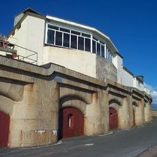
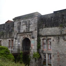
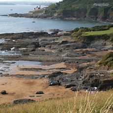
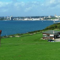
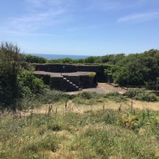
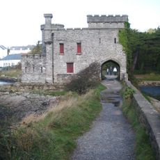
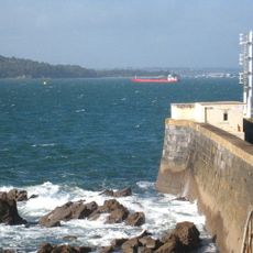
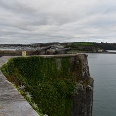
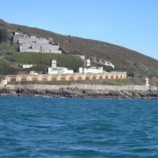
Staddon Fort is a military fortification on elevated terrain east of Plymouth, built with granite casemates and earthwork defenses to guard the harbor entrance. The structure occupies a strategic position overlooking the water and surrounding coastline.

The fort was built between 1861 and 1869 as part of a national defense network, constructed in response to fears of naval threats from France. It was originally equipped with guns and mortars positioned to cover the harbor approaches.

The fort represents Victorian military engineering principles, demonstrating the period's response to perceived French naval threats through extensive coastal fortification systems.

The site functions as an active Royal Navy facility and is not open to public visits. Security fencing surrounds the perimeter, preventing close access to the structures.

A military road links this fort to other coastal batteries across Staddon Heights, forming part of an interconnected defense system. This network allowed coordinated fire coverage of the approaches to Plymouth Harbor.

The community of curious travelers

AroundUs brings together thousands of curated places, local tips, and hidden gems, enriched daily by 60,000 contributors worldwide.

Start exploring
Location
Inception
1861
Part of
Staddon Heights Defences including Fort Staddon Fort, Brownhill Battery, Watch House Battery, Staddon Heights Battery, Staddon Battery and associated features and structures
GPS coordinates
50.34600,-4.11400
Latest update
December 14, 2025 12:24
Around this place
Fort Bovisand
United Kingdom

Fort Bovisand

1.4 km
RM Turnchapel
United Kingdom

RM Turnchapel

1.5 km
Radford
United Kingdom

Radford

1.1 km
Fort Stamford
United Kingdom

Fort Stamford

1.1 km
Plymouth Sound, Shores and Cliffs
United Kingdom

Plymouth Sound, Shores and Cliffs

574 m
Lord Howard's Battery
United Kingdom

Lord Howard's Battery

886 m
Lentney Battery
United Kingdom

Lentney Battery

2.4 km
Jennycliff
United Kingdom

Jennycliff

853 m
Tenpin
United Kingdom

Tenpin

2.4 km
Mount Batten Watersports & Activities
United Kingdom

Mount Batten Watersports & Activities

1.8 km
Mount Batten Beach
United Kingdom

Mount Batten Beach

1.6 km
Mount Batten Breakwater
United Kingdom

Mount Batten Breakwater

2.1 km
Church of St Mary and All Saints
United Kingdom

Church of St Mary and All Saints

2.4 km
Mount Batten Tower
United Kingdom

Mount Batten Tower

1.9 km
Plymstock Library
United Kingdom

Plymstock Library

2.4 km
Hooe Lake
United Kingdom

Hooe Lake

1.2 km
Flying Boat Hangars At Former Raf Mount Batten
United Kingdom

Flying Boat Hangars At Former Raf Mount Batten

1.7 km
Group Of 4 Second World War Coastal Artillery Search Lights
United Kingdom

Group Of 4 Second World War Coastal Artillery Search Lights

1.4 km
Radford Bridge And Castle
United Kingdom

Radford Bridge And Castle

1.4 km
Bovisand Harbour And Pier
United Kingdom

Bovisand Harbour And Pier

1.4 km
RAF Mount Batten Memorial
United Kingdom

RAF Mount Batten Memorial

2 km
Duttons Cafe (Former Artillery Store/Magazine)
United Kingdom

Duttons Cafe (Former Artillery Store/Magazine)

2.4 km
Staddon Heights Defences including Fort Staddon Fort, Brownhill Battery, Watch House Battery, Staddon Heights Battery, Staddon Battery and associated features and structures
United Kingdom

Staddon Heights Defences including Fort Staddon Fort, Brownhill Battery, Watch House Battery, Staddon Heights Battery, Staddon Battery and associated features and structures

479 m
Round barrow on Burrow Hill
United Kingdom

Round barrow on Burrow Hill

1.9 km
Boathouse, Armoury And St Kevernes Cottages
United Kingdom

Boathouse, Armoury And St Kevernes Cottages

1.6 km
Wilkinson's Battery
United Kingdom

Wilkinson's Battery

2.4 km
Staddon Heights Battery
United Kingdom

Staddon Heights Battery

1.3 km
Mount Batten: 17th century artillery tower, Civil War breastwork, and World War II remains
United Kingdom

Mount Batten: 17th century artillery tower, Civil War breastwork, and World War II remains

1.9 km
Show the full map
Reviews
Share your experience

No review yet

Discussions
Start a discussion...

No discussion yet

« Staddon Fort - Military fortification in Plymouth, United Kingdom » is provided by Around Us (aroundus.com). Images and texts are derived from Wikimedia project under a Creative Commons license. You are allowed to copy, distribute, and modify copies of this page, under the conditions set by the license, as long as this note is clearly visible.

Discover hidden gems everywhere you go!

From secret cafés to breathtaking viewpoints, skip the crowded tourist spots and find places that match your style. Our app makes it easy with voice search, smart filtering, route optimization, and insider tips from travelers worldwide. Download now for the complete mobile experience.

Around Us App Screenshot

A unique approach to discovering new places

Le Figaro

All the places worth exploring

France Info

A tailor-made excursion in just a few clicks

20 Minutes

Around Us
Travel Guide & Maps
Download

Send to your phone

QR Code
1

Open the camera app on your mobile.

2

Point at the QR code with your camera. A notification will appear.

3

Tap the notification to open the link.