'The Cross': a hill-figure war memorial at Lenham
'The Cross': a hill-figure war memorial at Lenham, Hill figure war memorial in Lenham, England
Description
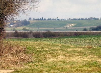
The Cross is a large white chalk cross carved into the hillside north of Lenham village, visible from many directions across the surrounding countryside. The figure measures approximately 188 feet tall by 60 feet wide and sits on the landscape as a striking tribute to those lost in war.
History
The memorial was established in 1922 to honour 42 local soldiers who fell during World War I. The names of 14 additional casualties from World War II were later added to reflect the ongoing costs of conflict on the community.
Culture
The memorial was created by local people to honour those lost and serves as a gathering place for reflection and remembrance. It stands openly on the hillside where visitors can connect with both the landscape and the stories of those commemorated.
Practical
The site is accessible via walking routes including the North Downs Way, which passes near the memorial. A commemorative bench on site provides a place to stop and spend time in quiet reflection.
Did you know?
During World War II the entire cross was buried under earth as a protective measure against bombing and remained hidden until May 1945. This wartime precaution meant the memorial was invisible to the community for several years.
AroundUs brings together thousands of curated places, local tips, and hidden gems, enriched daily by 60,000 contributors worldwide. Discover all places nearby (Lenham).
Chilston Park
2.9 km
Ringlestone Inn
4 km
Boughton Place
4 km
St John the Baptist's Church, Harrietsham
3.1 km
Tithe Barn, Lenham
1 km
St Mary's Church
938 m
Bell Farm House, Harrietsham
3.5 km
Church of St Dunstan
4.8 km
Church of St Margaret
3.1 km
Church of the Holy Trinity
3.7 km
Church of St Nicholas
4 km
Church of St Lawrence
4.4 km
The Blacksmith's Arms Public House
5.1 km
Lenham Library
908 m
Monument to George Powelle and others, circa 5 yards north of north porch of Church of St Mary
929 m
Yew Tree Farmhouse
5.1 km
The Lock-Up or Mortuary
905 m
Egerton House
4.9 km
Saxon Warriors
1 km
The Homestead
5.2 km
Otterden Place, And Donkey Wheel Attached
4.3 km
Marchant Farmhouse
5.2 km
Walnut Tree House
5.2 km
Milestone, Old Ashford Road, E of footpath to North Downs Way
762 m
Milestone, Maidstone Road, opp. Hook Cottages, W of village
4.9 km
Stonestile
4.1 km
Milestone, Ashford Road, E of village, under railway bridge
3.3 km
Milestone, Maidstone Road, W of Acton Farm
3.3 kmDiscover hidden gems everywhere you go!
From secret cafés to breathtaking viewpoints, skip the crowded tourist spots and find places that match your style. Our app makes it easy with voice search, smart filtering, route optimization, and insider tips from travelers worldwide. Download now for the complete mobile experience.
A unique approach to discovering new places❞
— Le Figaro
All the places worth exploring❞
— France Info
A tailor-made excursion in just a few clicks❞
— 20 Minutes