Sandyford House

Log in to your account

AroundUs is a community-driven map of interesting places, built by curious explorers like you. It grows with every review, story, and photo you share.
Connect to save your favorite spots, contribute locations, and create personalized routes.
By continuing, you accept our Terms and Conditions and our Privacy Policy
Add to collection
Map
Suggest a change
Share

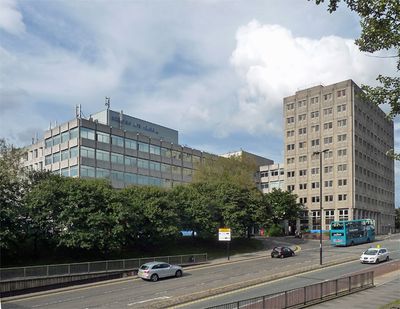
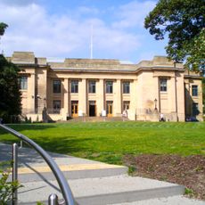
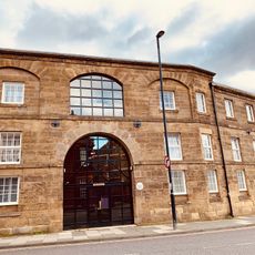
Sandyford House, Office building in Sandyford district, Newcastle upon Tyne, England.

Sandyford House is a six-story office building with reinforced concrete construction and glass facade elements located on Sandyford Road. The structure was originally designed as an administrative center and forms part of a larger commercial complex in this district.

The building served as the main headquarters for Tyne and Wear County Council from 1974 until 1986. It then housed the Department of Social Security operations before transitioning to other uses in later years.

The building became known for housing the editorial offices of Viz, a satirical comic magazine that gained devoted readers across Britain. It represents a significant location for independent creative work in the city.

The building is currently undergoing conversion into residential apartments with approved plans for a major redevelopment project. Visitors should be aware that access may be limited while construction work is taking place.

The site originally included the Royal Archer public house, which received recognition from the Royal Institute of British Architects in 1976. This local pub was an established part of the community before the complex developed.

Location: Newcastle upon Tyne

GPS coordinates: 54.98150,-1.60580

Latest update: December 14, 2025 09:41

Photos
Around this place
Newcastle Civic Centre
United Kingdom

Newcastle Civic Centre

428 m
Great North Museum: Hancock
United Kingdom

Great North Museum: Hancock

489 m
Faculty of Humanities and Social Sciences
United Kingdom

Faculty of Humanities and Social Sciences

354 m
Jesmond Parish Church
United Kingdom

Jesmond Parish Church

101 m
Jesmond Old Cemetery
United Kingdom

Jesmond Old Cemetery

460 m
Jesmond Synagogue
United Kingdom

Jesmond Synagogue

465 m
Hutton Terrace drill hall
United Kingdom

Hutton Terrace drill hall

334 m
Armstrong Memorial
United Kingdom

Armstrong Memorial

496 m
Tomb Of John Dobson About 175 Metres South Of Jesmond Cemetery Gates
United Kingdom

Tomb Of John Dobson About 175 Metres South Of Jesmond Cemetery Gates

372 m
Church of St James with Hall, Sunday School and House Attached
United Kingdom

Church of St James with Hall, Sunday School and House Attached

490 m
8-13, Brandling Park
United Kingdom

8-13, Brandling Park

424 m
Tomb Of Keenleyside Family About 80 Metres South Of Jesmond Cemetery Gates
United Kingdom

Tomb Of Keenleyside Family About 80 Metres South Of Jesmond Cemetery Gates

449 m
Tomb Of Tm Richardson About 20 Metres South West Of Jesmond Cemetery Gateway
United Kingdom

Tomb Of Tm Richardson About 20 Metres South West Of Jesmond Cemetery Gateway

435 m
Hancock Museum of Natural History building
United Kingdom

Hancock Museum of Natural History building

483 m
21, Brandling Park
United Kingdom

21, Brandling Park

493 m
United Bus Company Depot
United Kingdom

United Bus Company Depot

247 m
The Carriage Public House
United Kingdom

The Carriage Public House

79 m
River God Tyne
United Kingdom

River God Tyne

463 m
Former Boiler House, Sandyford Brewery
United Kingdom

Former Boiler House, Sandyford Brewery

388 m
Tomb Of A Reed About 100 Metres South West Of Jesmond Cemetery Gates
United Kingdom

Tomb Of A Reed About 100 Metres South West Of Jesmond Cemetery Gates

362 m
Carlton Terrace
United Kingdom

Carlton Terrace

294 m
Deuchar House
United Kingdom

Deuchar House

337 m
34-46, Brandling Place South
United Kingdom

34-46, Brandling Place South

410 m
Tomb Of Joseph Wilson About 35 Metres South West Of Jesmond Cemetery Gateway
United Kingdom

Tomb Of Joseph Wilson About 35 Metres South West Of Jesmond Cemetery Gateway

414 m
Piers From Hospital Of The Virgin Mary Of Royal Grammar School
United Kingdom

Piers From Hospital Of The Virgin Mary Of Royal Grammar School

158 m
22-28, Brandling Place South
United Kingdom

22-28, Brandling Place South

445 m
31, 32 And 33, Brandling Place South
United Kingdom

31, 32 And 33, Brandling Place South

423 m
Entrance Archway, Pair Of Chapel Lodges, Walls And Gates To Jesmond Cemetery
United Kingdom

Entrance Archway, Pair Of Chapel Lodges, Walls And Gates To Jesmond Cemetery

465 m
Show the full map
Reviews

Visited this place? Tap the stars to rate it and share your experience / photos with the community! Try now! You can cancel it anytime.

« Sandyford House - Office building in Sandyford district, Newcastle upon Tyne, England » is provided by Around Us (aroundus.com). Images and texts are derived from Wikimedia project under a Creative Commons license. You are allowed to copy, distribute, and modify copies of this page, under the conditions set by the license, as long as this note is clearly visible.

Discover hidden gems everywhere you go!

From secret cafés to breathtaking viewpoints, skip the crowded tourist spots and find places that match your style. Our app makes it easy with voice search, smart filtering, route optimization, and insider tips from travelers worldwide. Download now for the complete mobile experience.

Around Us App Screenshot

A unique approach to discovering new places

Le Figaro

All the places worth exploring

France Info

A tailor-made excursion in just a few clicks

20 Minutes