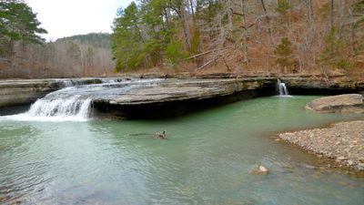
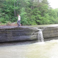
Falling Water Falls, Natural waterfall in Pope County, Arkansas.
The waterfall creates a continuous cascade of water flowing down limestone rocks, forming multiple tiers across the natural formation.
The site became a protected natural area in 1964, establishing permanent public access to observe this geological formation in Pope County.
Local photographers and nature artists regularly visit the falls to capture seasonal changes and water patterns throughout different times of year.
Visitors can access the waterfall through designated trails equipped with observation points and parking facilities near the entrance.
The water volume varies significantly between seasons, creating different visual patterns as it flows through multiple rock formations.
Location: Pope County
GPS coordinates: 35.72193,-92.94930
Latest update: March 14, 2025 10:55
Arkansas sits in the southern United States, where the Ozark and Ouachita mountains meet forested valleys and slow rivers. Away from the main highways, the state holds waterfalls hidden in national forests, abandoned settlements from mining days, and caves filled with limestone formations. Haw Creek Falls drops over a series of ledges in the Ozarks, while Blanchard Springs Caverns opens into chambers where underground streams have carved stone over thousands of years. Rush, once a zinc mining town, now stands empty along the Buffalo River. Boxley Valley offers open fields where elk graze beneath ridges, and the Cossatot River cuts through rocky rapids in the Ouachita range. These places show different chapters of the region's natural and human history. Historical sites and cultural centers add depth to the landscape. Monte Ne preserves the ruins of an early resort built beside Beaver Lake. The Hampson Archeological Museum holds artifacts from indigenous peoples who lived in the Mississippi River floodplain. Jacksonport once served as a river port on the White River, and the Delta Cultural Center documents the agricultural heritage of eastern Arkansas. From Sam's Throne, a rock outcrop with views across the Ozarks, to the old railway bridge in Clarendon, these locations lie off the usual routes and reward those who take the time to seek them out.
Sam's Throne
19.3 km
Union School
35.7 km
Big Piney Creek Bridge
26.4 km
Bank of Marshall Building
35.5 km
Henley Hotel
36.7 km
Little Buffalo River Bridge
37.2 km
Bates Tourist Court
35.5 km
Anthony Luna House
35.5 km
Farmers Bank Building
37.1 km
Bromley-Mills-Treece House
35.7 km
Dr. Clay House
37.2 km
Dr. Sam G. Daniel House
35.4 km
Searcy County Courthouse
35.4 km
Gates-Helm Farm
24.5 km
Thomas J. Hankins House
13.3 km
Van Buren County Road 2E Bridge
32.7 km
Sanders-Hollabaugh House
35.7 km
American Legion Post No. 131
37.1 km
Leslie Commercial Historic District
37.1 km
Mary Greenhaw Memorial Methodist Episcopal Church South
35.6 km
Charley Passmore House
35.2 km
Bud Fendley House
35.5 km
S.A. Lay House
35.5 km
Willmering Tourist Cabins Historic District
33 km
J.C. Miller House
37.3 km
J.M. McCall House
35.3 km
Dr. Cleveland Hollabaugh House
37.3 km
Haw Creek Falls Recreation Area
28.1 kmReviews
Visited this place? Tap the stars to rate it and share your experience / photos with the community! Try now! You can cancel it anytime.
Discover hidden gems everywhere you go!
From secret cafés to breathtaking viewpoints, skip the crowded tourist spots and find places that match your style. Our app makes it easy with voice search, smart filtering, route optimization, and insider tips from travelers worldwide. Download now for the complete mobile experience.
A unique approach to discovering new places❞
— Le Figaro
All the places worth exploring❞
— France Info
A tailor-made excursion in just a few clicks❞
— 20 Minutes