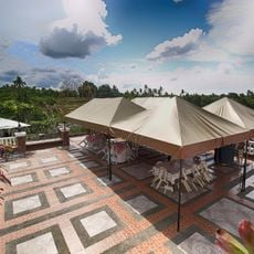
Sky Ranch, Theme park overlooking Taal Lake in Tagaytay, Philippines
Sky Ranch is a theme park on a mountainside in Tagaytay with carnival rides, dining options, and multiple viewing areas overlooking the valley below. The grounds feature different sections spread across the slopes where visitors can enjoy both attractions and scenic spots.
The park was established in 2013 and marked the first mountain-based leisure development of its kind in the country. This opening represented a new approach to how recreational facilities were built at elevated locations.
The park reflects how visitors seek places where nature and entertainment blend together in the mountains. Families move between attractions and gather at viewpoints, showing how this location has become a popular meeting spot for locals and tourists alike.
The park is easily accessible from the main roads and has several pathways for exploring different sections. Visitors should wear comfortable shoes since walking between attractions and viewpoints is necessary to see everything.
A large ferris wheel has air-conditioned cabins that lift visitors high above the park to see the entire valley landscape at once. This ride offers a perspective that ground-level attractions cannot provide.
Location: Tagaytay
Operator: SM
Address: Tagaytay - Nasugbu Hwy, Kaybagal South, Tagaytay, Cavite
Phone: +639150733440
Website: http://skyranch.ph
GPS coordinates: 14.09507,120.93803
Latest update: December 12, 2025 14:25
Taal Volcano
11.4 km
People's Park in the Sky
10.4 km
Mount Sungay
10.5 km
Silang Church
14.9 km
Puzzle Mansion
3.7 km
Matang Tubig
15.6 km
St. Gregory the Great Parish Church
16 km
Cuartel de Santo Domingo
19.3 km
Kaytitinga Falls
11.8 km
Apolinario Mabini Shrine
17.4 km
Villa Colmenar Natural Spring Resort
12.1 km
Tagaytay Ridge Landing historical marker
3.4 km
General Jose Ignacio Paua historical marker
17.1 km
41st Division Philippine Army (USAFFE) historical marker
117 m
General Nicolas Gonzales y Lantin historical marker
10.5 km
Severino de las Alas historical marker
13 km
Apolinario Mabini historical marker
17.4 km
Banio kreek
9.7 km
Vito Belarmino historical marker
14.3 km
The Capture of Bonifacio historical marker
12.3 km
Amadeo Municipal Hall
8.5 km
Bearseum
6.8 km
Site of Imprisonment of Andres Bonifacio historical marker
12.9 km
Town of Amadeo historical marker
8.5 km
Church of Silang historical marker
14.9 km
Parish of Saint Mary Magdalene historical marker
8.5 km
41st Division Philippine Army-USAFFE Shrine
134 m
Barracks of Santo Domingo historical marker
19.3 kmVisited this place? Tap the stars to rate it and share your experience / photos with the community! Try now! You can cancel it anytime.
Discover hidden gems everywhere you go!
From secret cafés to breathtaking viewpoints, skip the crowded tourist spots and find places that match your style. Our app makes it easy with voice search, smart filtering, route optimization, and insider tips from travelers worldwide. Download now for the complete mobile experience.
A unique approach to discovering new places❞
— Le Figaro
All the places worth exploring❞
— France Info
A tailor-made excursion in just a few clicks❞
— 20 Minutes