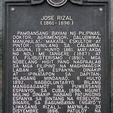
People's Park in the Sky, Hilltop park in Tagaytay, Philippines.
People's Park in the Sky occupies the summit of Mount Sungay, offering views across Taal Lake and the hills of Cavite province. Visitors reach the site via a winding road that leads to the remains of an unfinished building now used as a viewing platform.
Construction began in the early 1980s as a private retreat for the Marcos family but was never completed. After the political upheaval of 1986, the government opened the site to the public and renamed it to mark a shift in power.
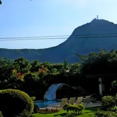
A religious shrine dedicated to Our Lady Mother of Fair Love draws worshippers who light candles and pray throughout the week. Families from nearby towns often visit after Sunday mass, treating the grounds as a gathering place where faith and leisure come together.
The site opens daily from early morning until late afternoon, with a modest admission fee for adults and free entry for children. Visitors seeking clear views should arrive in the morning before clouds and mist roll in during the afternoon.
A Doppler weather radar tower stands on the grounds, tracking storm systems across the Calabarzon region and feeding data to national forecasting networks. Visitors can spot the white painted structure near the main building, though the technical facility itself remains off-limits.
Location: Tagaytay
GPS coordinates: 14.14140,121.02200
Latest update: December 20, 2025 12:06
Mount Sungay
89 m
Silang Church
10.5 km
Puzzle Mansion
13.6 km
Matang Tubig
6.2 km
Cuartel de Santo Domingo
10.4 km
Sky Ranch
10.4 km
Apolinario Mabini Shrine
9.5 km
Tagaytay Ridge Landing historical marker
7.1 km
General Jose Ignacio Paua historical marker
12.5 km
Miguel Malvar historical marker
13.5 km
41st Division Philippine Army (USAFFE) historical marker
10.3 km
General Nicolas Gonzales y Lantin historical marker
172 m
Severino de las Alas historical marker
16.7 km
Apolinario Mabini historical marker
9.5 km
Church of Tanauan historical marker
15.5 km
Banio kreek
5.7 km
Vito Belarmino historical marker
10.1 km
Malvar Shrine
13.5 km
Villa Morales Resort
14.7 km
Amadeo Municipal Hall
11.2 km
The Capture of Bonifacio historical marker
14.4 km
Bearseum
10.3 km
Jose Rizal historical marker
16.1 km
Site of Imprisonment of Andres Bonifacio historical marker
16.6 km
Town of Amadeo historical marker
11.3 km
Parish of Saint Mary Magdalene historical marker
11.3 km
41st Division Philippine Army-USAFFE Shrine
10.3 km
Church of Silang historical marker
10.5 kmVisited this place? Tap the stars to rate it and share your experience / photos with the community! Try now! You can cancel it anytime.
Discover hidden gems everywhere you go!
From secret cafés to breathtaking viewpoints, skip the crowded tourist spots and find places that match your style. Our app makes it easy with voice search, smart filtering, route optimization, and insider tips from travelers worldwide. Download now for the complete mobile experience.
A unique approach to discovering new places❞
— Le Figaro
All the places worth exploring❞
— France Info
A tailor-made excursion in just a few clicks❞
— 20 Minutes