Enable Location

We need your location to show you interesting places around you

Discover nearby places

Find interesting locations and hidden gems around you

Precise directions

Get accurate directions and distances to places

Your location is never shared with other users. It's only used when you tap the location button.

Mount Sungay

Log in to your account

Start exploring — it's free

Trusted by 62,098 travelers worldwide

Continue with Google
Continue with Apple
or

We will send you a code to connect

By continuing, you accept our Terms and Conditions and our Privacy Policy

Check your inbox

We've sent a pincode in your inbox. Please enter the code below.

Mount Sungay

Mount Sungay, Mountain summit in Tagaytay, Philippines.

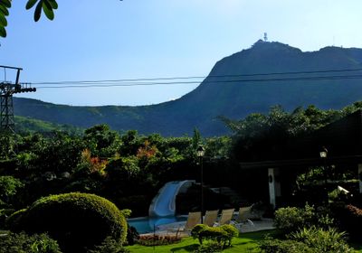
Mount Sungay rises to 709 meters above sea level as the highest point in Cavite province and forms part of the Tagaytay Ridge system. The mountain has a distinctive peak that stands out clearly against the surrounding landscape and is visible from various vantage points.

The sharp peak served as a navigation reference point for ships entering Manila Bay during early maritime expeditions in the Philippine archipelago. The distinctive shape helped seafarers determine their position while crossing the islands.

The name Sungay comes from a Tagalog word meaning horns, referring to how the mountain's rock formations originally pointed upward like sharp protrusions from the peak. Locals used this distinctive shape to identify and remember this landmark in the landscape.

The summit is accessible via a narrow road leading to a parking area, followed by a 300-meter hiking trail or jeepney ride to the top. The best time to visit is early morning when visibility is clear and the weather is cooler.

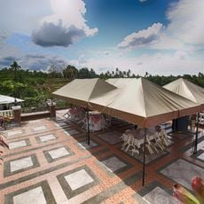
A former palace built in 1979 on the summit was later converted into a public park that offers views of Taal Lake. From this vantage point, visitors can see Manila Bay and neighboring mountain ranges stretching below.

The community of curious travelers

AroundUs brings together thousands of curated places, local tips, and hidden gems, enriched daily by 60,000 contributors worldwide.

Start exploring
Location
Elevation above the sea
709 m
Part of
Tagaytay Ridge
GPS coordinates
14.14220,121.02194
Latest update
December 10, 2025 16:03
« Mount Sungay - Mountain summit in Tagaytay, Philippines » is provided by Around Us (aroundus.com). Images and texts are derived from Wikimedia project under a Creative Commons license. You are allowed to copy, distribute, and modify copies of this page, under the conditions set by the license, as long as this note is clearly visible.

Discover hidden gems everywhere you go!

From secret cafés to breathtaking viewpoints, skip the crowded tourist spots and find places that match your style. Our app makes it easy with voice search, smart filtering, route optimization, and insider tips from travelers worldwide. Download now for the complete mobile experience.

Around Us App Screenshot

A unique approach to discovering new places

Le Figaro

All the places worth exploring

France Info

A tailor-made excursion in just a few clicks

20 Minutes

Around Us
Travel Guide & Maps
Download

Send to your phone

QR Code
1

Open the camera app on your mobile.

2

Point at the QR code with your camera. A notification will appear.

3

Tap the notification to open the link.