·

Enable Location

We need your location to show you interesting places around you

Discover nearby places

Find interesting locations and hidden gems around you

Precise directions

Get accurate directions and distances to places

Your location is never shared with other users. It's only used when you tap the location button.

Niles Scream Park

Log in to your account

Start exploring — it's free

Trusted by 62,734 travelers worldwide

Continue with Google
Continue with Apple
or

We will send you a code to connect

By continuing, you accept our Terms and Conditions and our Privacy Policy

Check your inbox

We've sent a pincode in your inbox. Please enter the code below.

Niles Scream Park

Niles Scream Park

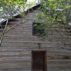
Niles Scream Park is a fright attraction covering roughly 44 acres in Niles Charter Township with multiple haunted experiences. The main haunted house features over 100 different routes through themed rooms including a basement and attic, while outdoor attractions include the Field of Screams maze, Wicked Woods forest area, escape rooms opening in 2025, and the Hooded experience where adults 18 and over are blindfolded for an intense encounter.

The park opened in 1996 and has become an established seasonal tradition in the region. The original haunted house has frightened visitors for more than two decades, while new attractions like Field of Screams, Wicked Woods, and the Hooded experience were gradually added to expand the park's offerings and keep the experience fresh each year.

The park is a gathering place where the local community actively participates through volunteers from over 70 local groups including scouts, churches, and school organizations. This grassroots involvement gives the experience special meaning, as visiting supports the neighborhood groups and youth organizations working there throughout the season.

The park is located at 855 Mayflower Road east of U.S. 31 Exit 5 and offers free parking with metal detector security screening at the entrance. Visitors should arrive early since attractions open when dark and the park typically closes between 10 and 11 p.m., though some attractions may stay open longer if crowds remain.

The park is a nonprofit operation that has donated over 2.8 million dollars to local charities and college scholarships for students at nearby high schools since opening in 1996. This community support mission means every visitor contributes directly to funding local programs and student scholarships.

The community of curious travelers

AroundUs brings together thousands of curated places, local tips, and hidden gems, enriched daily by 60,000 contributors worldwide.

Start exploring
Address
Mayflower Road
Phone
GPS coordinates
41.82450,-86.31841
Latest update
February 9, 2026 08:20
Around this place
Main Building
United States of America

Main Building

15 km
Fort St. Joseph
United States of America

Fort St. Joseph

4.8 km
Alumni Hall
United States of America

Alumni Hall

15.4 km
Moccasin Bluff Site
United States of America

Moccasin Bluff Site

5.3 km
Bond Hall
United States of America

Bond Hall

15.1 km
Log Chapel, University of Notre Dame
United States of America

Log Chapel, University of Notre Dame

15.1 km
Clarke Memorial Fountain
United States of America

Clarke Memorial Fountain

15.2 km
Washington Hall
United States of America

Washington Hall

15.1 km
LaFortune Student Center
United States of America

LaFortune Student Center

15.2 km
Muessel-Drewry Brewery
United States of America

Muessel-Drewry Brewery

15.1 km
Fernwood Botanical Garden and Nature Preserve
United States of America

Fernwood Botanical Garden and Nature Preserve

5.1 km
Berrien Springs Courthouse
United States of America

Berrien Springs Courthouse

13.9 km
Water Street/Darden Road Bridge
United States of America

Water Street/Darden Road Bridge

11.3 km
Old Berrien County Courthouse Complex
United States of America

Old Berrien County Courthouse Complex

13.9 km
Crystal Springs Street–Dowagiac River Bridge
United States of America

Crystal Springs Street–Dowagiac River Bridge

14.6 km
St. Joseph County Infirmary
United States of America

St. Joseph County Infirmary

12.2 km
Niles Downtown Historic District
United States of America

Niles Downtown Historic District

5.2 km
Thomson Road–Air Line Railroad Bridge
United States of America

Thomson Road–Air Line Railroad Bridge

12.8 km
Marquette School
United States of America

Marquette School

14.1 km
Ring Lardner House
United States of America

Ring Lardner House

5.3 km
Notre Dame Old Fieldhouse
United States of America

Notre Dame Old Fieldhouse

15.3 km
Buchanan North and West Neighborhoods Historic District
United States of America

Buchanan North and West Neighborhoods Historic District

3.9 km
Union Block
United States of America

Union Block

3.5 km
Word of Life
United States of America

Word of Life

15.3 km
Henry A. Chapin House
United States of America

Henry A. Chapin House

5.4 km
Ring Lardner Historical Marker
United States of America

Ring Lardner Historical Marker

5.3 km
Fort Saint Joseph Historical Marker
United States of America

Fort Saint Joseph Historical Marker

4.9 km
Fort Saint Joseph Monument
United States of America

Fort Saint Joseph Monument

4.9 km
Show the full map
« Niles Scream Park » is provided by Around Us (aroundus.com). Images and texts are derived from Wikimedia project under a Creative Commons license. You are allowed to copy, distribute, and modify copies of this page, under the conditions set by the license, as long as this note is clearly visible.

Discover hidden gems everywhere you go!

From secret cafés to breathtaking viewpoints, skip the crowded tourist spots and find places that match your style. Our app makes it easy with voice search, smart filtering, route optimization, and insider tips from travelers worldwide. Download now for the complete mobile experience.

Around Us App Screenshot

A unique approach to discovering new places

Le Figaro

All the places worth exploring

France Info

A tailor-made excursion in just a few clicks

20 Minutes

Around Us
Travel Guide & Maps
Download

Send to your phone

QR Code
1

Open the camera app on your mobile.

2

Point at the QR code with your camera. A notification will appear.

3

Tap the notification to open the link.