Enable Location

We need your location to show you interesting places around you

Discover nearby places

Find interesting locations and hidden gems around you

Precise directions

Get accurate directions and distances to places

Your location is never shared with other users. It's only used when you tap the location button.

Fort St. Joseph

Log in to your account

Start exploring — it's free

Trusted by 64,787 travelers worldwide

Continue with Google
Continue with Apple
or

We will send you a code to connect

By continuing, you accept our Terms and Conditions and our Privacy Policy

Check your inbox

We've sent a pincode in your inbox. Please enter the code below.

Discussion Reviews 1 Photos
7k Popularity

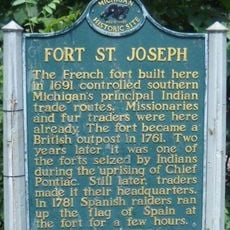
Fort St. Joseph, Colonial fort and archaeological site in Niles, United States.

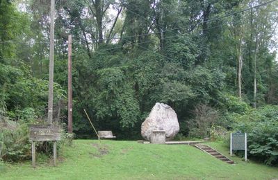
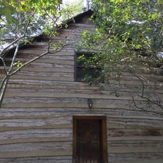
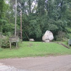
Fort St. Joseph is an archaeological site from the French colonial period on the banks of the St. Joseph River in Niles, Michigan. The partially excavated remains of military and residential structures sit close to the river and are actively studied by Western Michigan University.

The post was founded in 1691 by French traders and missionaries as a base for the fur trade. After the Seven Years War ended, it passed to British hands in 1761 and was soon abandoned.

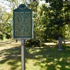
Fort St. Joseph was a meeting point where French traders, soldiers, and people from several Native nations came together in daily life. Today, the site uses display panels and excavated objects to show how that shared life actually worked on the ground.

The grounds are open and marked with information panels about the ongoing digs. In summer, students from Western Michigan University often work on-site, which gives visitors a chance to watch real archaeological work in progress.

One of the finds recovered at the site is a Jesuit religious medallion from the 1730s, preserved in the riverbank soil for decades. This single object confirms that missionaries were actively present at such a remote outpost, something no written record had made clear before.

The community of curious travelers

AroundUs brings together thousands of curated places, local tips, and hidden gems, enriched daily by 60,000 contributors worldwide.

Start exploring
Location
Inception
1680
Part of
New France
GPS coordinates
41.81361,-86.26222
Latest update
March 3, 2026 08:18
Around this place
Notre Dame Stadium
United States of America

Notre Dame Stadium

13 km
Main Building
United States of America

Main Building

12.5 km
Snite Museum of Art
United States of America

Snite Museum of Art

12.9 km
Alumni Hall
United States of America

Alumni Hall

12.8 km
Moccasin Bluff Site
United States of America

Moccasin Bluff Site

9.8 km
Bond Hall
United States of America

Bond Hall

12.6 km
Log Chapel, University of Notre Dame
United States of America

Log Chapel, University of Notre Dame

12.6 km
Clarke Memorial Fountain
United States of America

Clarke Memorial Fountain

12.6 km
Washington Hall
United States of America

Washington Hall

12.6 km
Joyce Center
United States of America

Joyce Center

13.1 km
Niles Scream Park
United States of America

Niles Scream Park

4.8 km
LaFortune Student Center
United States of America

LaFortune Student Center

12.6 km
Fernwood Botanical Garden and Nature Preserve
United States of America

Fernwood Botanical Garden and Nature Preserve

9.1 km
Smith's Chapel
United States of America

Smith's Chapel

10.9 km
Water Street/Darden Road Bridge
United States of America

Water Street/Darden Road Bridge

9.3 km
St. Joseph County Infirmary
United States of America

St. Joseph County Infirmary

10.7 km
Niles Downtown Historic District
United States of America

Niles Downtown Historic District

1.9 km
Thomson Road–Air Line Railroad Bridge
United States of America

Thomson Road–Air Line Railroad Bridge

10.5 km
Marquette School
United States of America

Marquette School

12.5 km
Ring Lardner House
United States of America

Ring Lardner House

1.2 km
Notre Dame Old Fieldhouse
United States of America

Notre Dame Old Fieldhouse

12.6 km
Buchanan North and West Neighborhoods Historic District
United States of America

Buchanan North and West Neighborhoods Historic District

8.7 km
Union Block
United States of America

Union Block

8.3 km
Word of Life
United States of America

Word of Life

12.6 km
Henry A. Chapin House
United States of America

Henry A. Chapin House

1.9 km
Fort Saint Joseph Monument
United States of America

Fort Saint Joseph Monument

140 m
Fort Saint Joseph Historical Marker
United States of America

Fort Saint Joseph Historical Marker

116 m
Ring Lardner Historical Marker
United States of America

Ring Lardner Historical Marker

1.2 km
Show the full map
Reviews
Share your experience

No review yet

Discussions
Start a discussion...

No discussion yet

« Fort St. Joseph - Colonial fort and archaeological site in Niles, United States » is provided by Around Us (aroundus.com). Images and texts are derived from Wikimedia project under a Creative Commons license. You are allowed to copy, distribute, and modify copies of this page, under the conditions set by the license, as long as this note is clearly visible.

Discover hidden gems everywhere you go!

From secret cafés to breathtaking viewpoints, skip the crowded tourist spots and find places that match your style. Our app makes it easy with voice search, smart filtering, route optimization, and insider tips from travelers worldwide. Download now for the complete mobile experience.

Around Us App Screenshot

A unique approach to discovering new places

Le Figaro

All the places worth exploring

France Info

A tailor-made excursion in just a few clicks

20 Minutes

Around Us
Travel Guide & Maps
Download

Send to your phone

QR Code
1

Open the camera app on your mobile.

2

Point at the QR code with your camera. A notification will appear.

3

Tap the notification to open the link.