Rust en Vrede
Location: Oudtshoorn Local Municipality
GPS coordinates: -33.39388,22.35749
Latest update: November 7, 2025 13:10

Cango Caves
13.2 km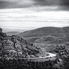
Swartberg
3 km
Cango Wildlife Ranch
23.4 km
Boomplaas Cave
18.7 km
CP Nel Museum
26.4 km
Cango Wildlife Ranch
23.4 km
Koos Raubenheimer Reservoir
7 km
Die Ou Tol
18.3 km
Rus en Vrede
67 m
Stompdrift Reservoir
27.2 km
Donkerhoek
15.2 km
Die Blaasbalk
18.8 km
Waterval
28.5 km
Die Top
29.3 km
Oudtshoorn Golf Club
25 km
Rock Pool
28 km
Cango Caves Zipline
13.3 km
Cango Ostrich Farm
14 km
Ma Betty's Cultural Village
26 km
Meiringspoort Falls
18.6 km
Skelmdraai
27.3 km
Scenic viewpoint
28.5 km
Scenic viewpoint
13.3 km
Memorial, commemorative plaque
29.3 km
Meiringspoort Falls
18.7 km
Waterfall
18.1 km
Waterfall
28.8 km
Waterfall
41 mReviews
Visited this place? Tap the stars to rate it and share your experience / photos with the community! Try now! You can cancel it anytime.
Discover hidden gems everywhere you go!
From secret cafés to breathtaking viewpoints, skip the crowded tourist spots and find places that match your style. Our app makes it easy with voice search, smart filtering, route optimization, and insider tips from travelers worldwide. Download now for the complete mobile experience.

A unique approach to discovering new places❞
— Le Figaro
All the places worth exploring❞
— France Info
A tailor-made excursion in just a few clicks❞
— 20 Minutes