Горный хребет Удокан
Location: Нерюнгринский улус
GPS coordinates: 57.07988,119.79964
Latest update: October 27, 2025 03:56

Chara Sands
103.6 km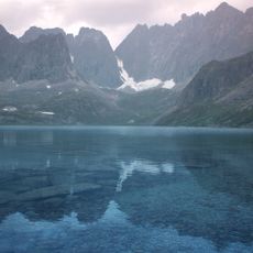
Vitim Nature Reserve
181.2 km
Pik BAM
137 km
Kodar National Park
137.9 km
Сиреневый Камень
146.9 km
Aku Volcano
174.9 km
Udokan Plateau
152.7 km
Relief sculpture, Work of art
199.3 km
Памятник погибшим войнам
125 km
Mural, Work of art
97.5 km
Work of art, mural
97.7 km
Mural, Work of art
98 km
Work of art, mural
97.8 km
Mural, Work of art
97.8 km
Остатки моста
128.7 km
Scenic viewpoint
99.8 km
Memorial
94.9 km
Стела
124.1 km
Инсталляция на дюне
104.1 km
25 лет Новой Чаре
97.7 km
Казахстан БАМу
97.7 km
СМП-578
98.4 km
50 лет БАМ
199.3 km
Участникам ВОВ
56.8 km
50 лет БАМ
56.8 km
М.С. Лунину
20.7 km
50 лет БАМ
20.7 km
2ТЭ10М-2466
97.6 kmVisited this place? Tap the stars to rate it and share your experience / photos with the community! Try now! You can cancel it anytime.
Discover hidden gems everywhere you go!
From secret cafés to breathtaking viewpoints, skip the crowded tourist spots and find places that match your style. Our app makes it easy with voice search, smart filtering, route optimization, and insider tips from travelers worldwide. Download now for the complete mobile experience.

A unique approach to discovering new places❞
— Le Figaro
All the places worth exploring❞
— France Info
A tailor-made excursion in just a few clicks❞
— 20 Minutes