Enable Location

We need your location to show you interesting places around you

Discover nearby places

Find interesting locations and hidden gems around you

Precise directions

Get accurate directions and distances to places

Your location is never shared with other users. It's only used when you tap the location button.

Chara Sands

Log in to your account

Start exploring — it's free

Trusted by 62,370 travelers worldwide

Continue with Google
Continue with Apple
or

We will send you a code to connect

By continuing, you accept our Terms and Conditions and our Privacy Policy

Check your inbox

We've sent a pincode in your inbox. Please enter the code below.

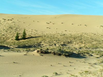
Chara Sands, Protected sand area in Zabaikalsky region, Russia

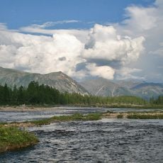
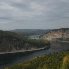
Chara Sands is a protected sand area in Zabaikalsky region, nestled between pine and larch forests in a valley stretch near the Kodar Mountains. The dunes rise up to 30 meters high and form gentle crests interrupted by small ponds and low grasses.

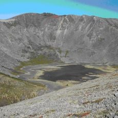
The sands formed from deposits of a glacial lake that existed between 55,000 and 100,000 years ago. Glaciers from the Kodar range fed this lake until the retreat of ice masses left the basin dry.

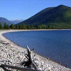
Reindeer herds cross the dunes on seasonal routes and use the small lakes as watering spots. Local herders know these patterns and adjust their movements to the rhythm of the animals.

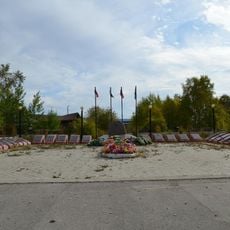
Visiting is easiest in summer when roads to the sand field are passable and temperatures allow for moderate day hikes. The village of Chara is nearby and offers starting points for tours that may take several hours.

Annual rainfall measures around 35 centimeters, relatively low for Siberia and favorable for dune formation. Geologists study this formation because it helps explain how sand fields develop in cold climates.

The community of curious travelers

AroundUs brings together thousands of curated places, local tips, and hidden gems, enriched daily by 60,000 contributors worldwide.

Start exploring
Inception
January 14, 1980
GPS coordinates
56.84000,118.15000
Latest update
December 5, 2025 22:28
Around this place
Patomskiy crater
Russian Federation

Patomskiy crater

287.2 km
Devil's Bridge
Russian Federation

Devil's Bridge

300.5 km
Highland of Aldan
Russian Federation

Highland of Aldan

428.8 km
Olyokma Nature Reserve
Russian Federation

Olyokma Nature Reserve

316.8 km
Vitim Nature Reserve
Russian Federation

Vitim Nature Reserve

90.8 km
Barguzin Range
Russian Federation

Barguzin Range

540.2 km
Chitinsky Datsan
Russian Federation

Chitinsky Datsan

611.3 km
Dzherginsky Nature Reserve
Russian Federation

Dzherginsky Nature Reserve

458.7 km
Pik BAM
Russian Federation

Pik BAM

35 km
Kodar National Park
Russian Federation

Kodar National Park

35.5 km
Russian Federation

Сиреневый Камень

176.1 km
Russian Federation

Aku Volcano

85 km
Udokan Plateau
Russian Federation

Udokan Plateau

66.6 km
Troitsky monastery
Russian Federation

Troitsky monastery

611.5 km
Lenskiye Shchyoki
Russian Federation

Lenskiye Shchyoki

478 km
Frolikha Adventure Coastline Track
Russian Federation

Frolikha Adventure Coastline Track

542.4 km
Памятник воинам-землякам, погибшим в годы Великой Отечественной войны (Томмот)
Russian Federation

Памятник воинам-землякам, погибшим в годы Великой Отечественной войны (Томмот)

535.4 km
Mamakan Reservoir
Russian Federation

Mamakan Reservoir

269.9 km
Lensk war memorial
Russian Federation

Lensk war memorial

469.8 km
Мемориал Славы (Нерюнгри)
Russian Federation

Мемориал Славы (Нерюнгри)

400.3 km
Мемориал воинской Славы (Витим)
Russian Federation

Мемориал воинской Славы (Витим)

436.9 km
Памятник И. Н. Кульбертинову (Олёкминск)
Russian Federation

Памятник И. Н. Кульбертинову (Олёкминск)

414.4 km
Ягодний (Амурська область)
Russian Federation

Ягодний (Амурська область)

400.7 km
Orthodox church of the New Martyrs and Confessors of Russia in Aldan
Russian Federation

Orthodox church of the New Martyrs and Confessors of Russia in Aldan

473 km
Road bridge over Aldan River in Tommot
Russian Federation

Road bridge over Aldan River in Tommot

535.6 km
Railway bridge through Amga river in Verkhnyaya Amga
Russian Federation

Railway bridge through Amga river in Verkhnyaya Amga

610.8 km
Lensk Troyka monument
Russian Federation

Lensk Troyka monument

469.6 km
Railway bridge through Aldan river in Tommot
Russian Federation

Railway bridge through Aldan river in Tommot

535.6 km
Show the full map
« Chara Sands - Protected sand area in Zabaikalsky region, Russia » is provided by Around Us (aroundus.com). Images and texts are derived from Wikimedia project under a Creative Commons license. You are allowed to copy, distribute, and modify copies of this page, under the conditions set by the license, as long as this note is clearly visible.

Discover hidden gems everywhere you go!

From secret cafés to breathtaking viewpoints, skip the crowded tourist spots and find places that match your style. Our app makes it easy with voice search, smart filtering, route optimization, and insider tips from travelers worldwide. Download now for the complete mobile experience.

Around Us App Screenshot

A unique approach to discovering new places

Le Figaro

All the places worth exploring

France Info

A tailor-made excursion in just a few clicks

20 Minutes

Around Us
Travel Guide & Maps
Download

Send to your phone

QR Code
1

Open the camera app on your mobile.

2

Point at the QR code with your camera. A notification will appear.

3

Tap the notification to open the link.