Chest opened
+${chestReward.xp} XP
Explorer
NOUVEAU ×${chestReward.collectible.quantity}
tapez pour fermer

See the monuments around you in AR Open chests in the app

Around Us is built for your phone — point your camera at the streets and discover the monuments and places around you in augmented reality. Around Us is built for your phone — chests unlock when you walk, explore and capture nearby places.

•

Enable Location

We need your location to show you interesting places around you

Discover nearby places

Find interesting locations and hidden gems around you

Precise directions

Get accurate directions and distances to places

Your location is never shared with other users. It's only used when you tap the location button.

Devil's Bridge

Log in to your account

Start exploring — it's free

Trusted by 89,774 travelers worldwide

Continue with Google
Continue with Apple
or

We will send you a code to connect

By continuing, you accept our Terms and Conditions and our Privacy Policy

Check your inbox

We've sent a pincode in your inbox. Please enter the code below.

Devil's Bridge
Discussion Reviews 1 Photos
11.3k Popularity

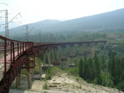
Devil's Bridge, Railway bridge in Severomuysky Detour, Russia.

Audio guide · About one minute
Preparing your audio guide… The audio guide could not be loaded, please retry.Sign in to listen to the audio guide

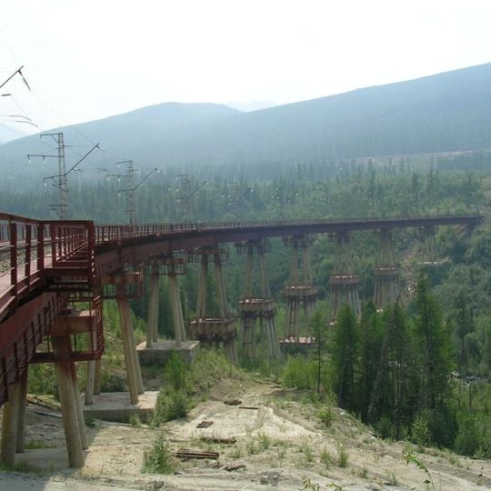
Devil's Bridge is a railway bridge that rises 35 meters above the Itykit River in Buryatia and forms a critical link on the Baikal-Amur Mainline. It spans a deep gorge with sturdy steel construction in a region of extreme climate and challenging terrain.

The bridge was built to carry trains across the deep Itykit River gorge in one of Russia's most remote regions. After the Severomuysky tunnel was completed in 2003, its role as the main route declined, yet it remains in operation today.

The name comes from local traditions of naming structures in remote areas after supernatural entities to reflect the harsh conditions. Today, you can see how the bridge sits within the landscape and how it connects communities across the valley.

You can best view the bridge from alongside the railway line, though remember it is an active railway area. Keep clear of the tracks and note that the region becomes extremely cold, making warmer months the better time to visit.

In winter, trains crossing the bridge require additional locomotives due to the steep gradient and weight limitations. This extra effort shows just how extreme conditions are in this remote mountain region.

The community of curious travelers

AroundUs brings together thousands of curated places, local tips, and hidden gems, enriched daily by 60,000 contributors worldwide.

Start exploring
Location
Inception
January 1, 1986
Height
35 m
Operator
ОАО "РЖД"
GPS coordinates
56.27156,113.36039
Latest update
September 17, 2026 02:07
Around this place
Dzherginsky Nature Reserve
Russian Federation

Dzherginsky Nature Reserve

109.1 mi
Baunt
Russian Federation

Baunt

76.8 mi
Mamakan Reservoir
Russian Federation

Mamakan Reservoir

109.3 mi
Busani
Russian Federation

Busani

64.6 mi
Balan-Tamur
Russian Federation

Balan-Tamur

95.9 mi
Russian Federation

Porog Paramsky

82.9 mi
Russian Federation

Shivera Tul’dunskaya

93.5 mi
Russian Federation

В честь открытия Северомуйского тоннеля (2003 г.)

8.9 mi
Russian Federation

Memorial

10.5 mi
Russian Federation

498км Баргузинского тракта

131 mi
Russian Federation

Gulag ruins Akukan mine

139.5 mi
Russian Federation

Ж/д "Чёртов мост" на БАМе

110 ft
Russian Federation

Monument of nature "The rill Umheiskiy"

124.7 mi
Russian Federation

Memorial

113.7 mi
Russian Federation

Источник Умхейский

124.7 mi
Russian Federation

Место начала Бодайбо

113.2 mi
Russian Federation

Памятник старателям

113.4 mi
Russian Federation

Памятник основанию г. Бодайбо

113.2 mi
Russian Federation

Monument of nature "The rill Kuchigerskiy"

133.2 mi
Russian Federation

Стелла границы Иркутской области

57.6 mi
Russian Federation

Гусеничный транспортёр-тягач

10.8 mi
Russian Federation

Братская могила

139.1 mi
Russian Federation

Жертвам Ленского расстрела 1912 года

140.1 mi
Russian Federation

Memorial

57 mi
Russian Federation

Табличка 110-й зимник

102.9 mi
Russian Federation

Memorial

132.5 mi
Russian Federation

Водопад надежды

138.9 mi
Russian Federation

Фролихинский водопад (15 м)

136.8 mi
Show the full map
Reviews
Share your experience

No review yet

Discussions
Start a discussion...

No discussion yet

« Devil's Bridge - Railway bridge in Severomuysky Detour, Russia » is provided by Around Us (aroundus.com). Images and texts are derived from Wikimedia project under a Creative Commons license. You are allowed to copy, distribute, and modify copies of this page, under the conditions set by the license, as long as this note is clearly visible.

Discover hidden gems everywhere you go!

From secret cafés to breathtaking viewpoints, skip the crowded tourist spots and find places that match your style. Our app makes it easy with voice search, smart filtering, route optimization, and insider tips from travelers worldwide. Download now for the complete mobile experience.

Around Us App Screenshot
❝

A unique approach to discovering new places❞

— Le Figaro

❝

All the places worth exploring❞

— France Info

❝

A tailor-made excursion in just a few clicks❞

— 20 Minutes

Around Us
Travel Guide & Maps
Download

Send to your phone

QR Code
1

Open the camera app on your mobile.

2

Point at the QR code with your camera. A notification will appear.

3

Tap the notification to open the link.