Enable Location

We need your location to show you interesting places around you

Discover nearby places

Find interesting locations and hidden gems around you

Precise directions

Get accurate directions and distances to places

Your location is never shared with other users. It's only used when you tap the location button.

Olyokma Nature Reserve

Log in to your account

Start exploring — it's free

Trusted by 64,779 travelers worldwide

Continue with Google
Continue with Apple
or

We will send you a code to connect

By continuing, you accept our Terms and Conditions and our Privacy Policy

Check your inbox

We've sent a pincode in your inbox. Please enter the code below.

Olyokma Nature Reserve
Discussion Reviews 1 Photos
6.4k Popularity

Olyokma Nature Reserve, Protected area in Sakha, Russia

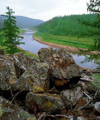
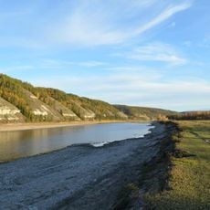
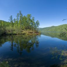
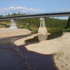
Olyokma Nature Reserve is a protected area in the Sakha Republic of East Siberia, Russia, covering rolling hills, river valleys, and open larch-dominated coniferous forests. The Olyokma River and its tributaries run through the reserve, linking highland ecosystems with lowland taiga.

Soviet authorities created the reserve in 1984 to protect East Siberian ecosystems from rising pressure caused by resource extraction and development. It became part of a national network of strictly protected areas known as zapovedniks, a system that dates back to the early 20th century.

The Yakut and Evenki peoples have hunted, fished, and gathered in these forests for generations, and their knowledge of the land still shapes how the area is understood today. Villages near the reserve maintain ways of life closely tied to the taiga and its rivers.

Visiting requires a special permit, which can be arranged through the reserve's administration office in the nearby town of Olekminsk. Winters are extreme and summers short, so the timing of a visit matters greatly, and local guidance is strongly advised.

The reserve is one of the few places in East Siberia where the sable, a small marten once hunted heavily for its fur, still lives in healthy numbers. Protection of this animal was one of the original reasons the area was considered for conservation long before the reserve was formally established.

The community of curious travelers

AroundUs brings together thousands of curated places, local tips, and hidden gems, enriched daily by 60,000 contributors worldwide.

Start exploring
Location
Inception
January 3, 1984
GPS coordinates
58.65606,122.25767
Latest update
March 3, 2026 22:40
Around this place
Lena Pillars
Russian Federation

Lena Pillars

394.4 km
Patomskiy crater
Russian Federation

Patomskiy crater

332.6 km
Chara Sands
Russian Federation

Chara Sands

316.8 km
Highland of Aldan
Russian Federation

Highland of Aldan

207.7 km
Vitim Nature Reserve
Russian Federation

Vitim Nature Reserve

360.3 km
Pik BAM
Russian Federation

Pik BAM

342 km
Kodar National Park
Russian Federation

Kodar National Park

343.5 km
Russian Federation

Сиреневый Камень

188.2 km
Russian Federation

Aku Volcano

398.3 km
Udokan Plateau
Russian Federation

Udokan Plateau

376.9 km
Buotama
Russian Federation

Buotama

359.1 km
Памятник воинам-землякам, погибшим в годы Великой Отечественной войны (Томмот)
Russian Federation

Памятник воинам-землякам, погибшим в годы Великой Отечественной войны (Томмот)

234 km
Mamakan Reservoir
Russian Federation

Mamakan Reservoir

490.9 km
Lensk war memorial
Russian Federation

Lensk war memorial

472.2 km
Мемориал Славы (Нерюнгри)
Russian Federation

Мемориал Славы (Нерюнгри)

265.5 km
Памятник И. Н. Кульбертинову (Олёкминск)
Russian Federation

Памятник И. Н. Кульбертинову (Олёкминск)

217.7 km
Orthodox church of the New Martyrs and Confessors of Russia in Aldan
Russian Federation

Orthodox church of the New Martyrs and Confessors of Russia in Aldan

181.3 km
Road bridge over Aldan River in Tommot
Russian Federation

Road bridge over Aldan River in Tommot

234.6 km
Lensk Troyka monument
Russian Federation

Lensk Troyka monument

471.3 km
Railway bridge through Aldan river in Tommot
Russian Federation

Railway bridge through Aldan river in Tommot

234.5 km
Railway bridge through Amga river in Verkhnyaya Amga
Russian Federation

Railway bridge through Amga river in Verkhnyaya Amga

298.7 km
Railway bridge through Lyutenge river
Russian Federation

Railway bridge through Lyutenge river

452.7 km
Road bridge over Amga River in Verkhnyaya Amga
Russian Federation

Road bridge over Amga River in Verkhnyaya Amga

298.6 km
Turuk Khaya Rocks
Russian Federation

Turuk Khaya Rocks

497.2 km
Railway bridge through Menda river
Russian Federation

Railway bridge through Menda river

508 km
Railway bridge through Kirim river
Russian Federation

Railway bridge through Kirim river

477.4 km
Rail bridge over Ulu river
Russian Federation

Rail bridge over Ulu river

345.3 km
Railway bridge through Lyutenge river
Russian Federation

Railway bridge through Lyutenge river

496.4 km
Show the full map
Reviews
Share your experience

No review yet

Discussions
Start a discussion...

No discussion yet

« Olyokma Nature Reserve - Protected area in Sakha, Russia » is provided by Around Us (aroundus.com). Images and texts are derived from Wikimedia project under a Creative Commons license. You are allowed to copy, distribute, and modify copies of this page, under the conditions set by the license, as long as this note is clearly visible.

Discover hidden gems everywhere you go!

From secret cafés to breathtaking viewpoints, skip the crowded tourist spots and find places that match your style. Our app makes it easy with voice search, smart filtering, route optimization, and insider tips from travelers worldwide. Download now for the complete mobile experience.

Around Us App Screenshot

A unique approach to discovering new places

Le Figaro

All the places worth exploring

France Info

A tailor-made excursion in just a few clicks

20 Minutes

Around Us
Travel Guide & Maps
Download

Send to your phone

QR Code
1

Open the camera app on your mobile.

2

Point at the QR code with your camera. A notification will appear.

3

Tap the notification to open the link.