Miradouro Serra do Cume

Log in to your account

AroundUs is a community-driven map of interesting places, built by curious explorers like you. It grows with every review, story, and photo you share.
Connect to save your favorite spots, contribute locations, and create personalized routes.
By continuing, you accept our Terms and Conditions and our Privacy Policy

Miradouro Serra do Cume

Add to collection
Map
Suggest a change
Share

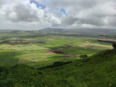
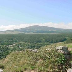
Miradouro Serra do Cume, Panoramic viewpoint in Terceira Island, Portugal

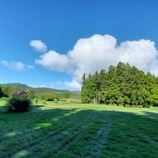
Miradouro Serra do Cume is a scenic viewpoint on Terceira Island in Portugal offering views across green pastures divided into geometric patterns. The landscape below shows countless small field divisions that create a patchwork effect across the eastern terrain.

The agricultural development of this region traces back to Portuguese settlement of Terceira Island in the 15th century. The field divisions reflect centuries of land-use practices that evolved over generations of farming.

The divided fields visible from this viewpoint show traditional farming methods of the Azores, where stone walls separate plots used for cattle grazing and crop production.

The viewpoint is accessible year-round via a paved road and has a parking area available. Visit on clear days to enjoy unobstructed views across the entire eastern landscape.

On clear days, visitors can see both the Atlantic Ocean and the Ilhéus das Cabras islets from this spot in a single view. This combined perspective reveals both the marine landscape and the island's interior in one moment.

Location: Praia da Vitória (Santa Cruz)

Address: R. Padre Damião 23, 9760 Praia da Vitória, Portugal

GPS coordinates: 38.70946,-27.11240

Latest update: December 6, 2025 17:44

Photos
Azores: volcanic nature, botanical gardens and island heritage

The Azores archipelago is located approximately 930 miles (1500 km) off the coast of Portugal in the Atlantic. The volcanic origin of the nine islands has shaped a landscape featuring crater lakes, active hot springs, caves carved into the rock, and botanical gardens arranged around geothermal basins. São Miguel hosts many of these sites, including Parque Terra Nostra in Furnas with its 102°F (39°C) ferruginous pools, the Fogo Lake at 1,887 meters (6,191 ft) above sea level, and the Gorreana tea plantation, operating since 1883. The archipelago also features geological formations accessible to visitors, such as Algar do Carvão on Terceira, descending 90 meters (295 feet) underground, and Vila Franca do Campo, an old crater now a lagoon. Pico's vineyards, listed as a UNESCO World Heritage Site, demonstrate agricultural adaptation to volcanic terrain. Beyond natural sights, several religious and civil buildings dating from the 16th century remain in historic towns, notably in Angra do Heroísmo on Terceira.

Reviews

Visited this place? Tap the stars to rate it and share your experience / photos with the community! Try now! You can cancel it anytime.

« Miradouro Serra do Cume - Panoramic viewpoint in Terceira Island, Portugal » is provided by Around Us (aroundus.com). Images and texts are derived from Wikimedia project under a Creative Commons license. You are allowed to copy, distribute, and modify copies of this page, under the conditions set by the license, as long as this note is clearly visible.

Discover hidden gems everywhere you go!

From secret cafés to breathtaking viewpoints, skip the crowded tourist spots and find places that match your style. Our app makes it easy with voice search, smart filtering, route optimization, and insider tips from travelers worldwide. Download now for the complete mobile experience.

Around Us App Screenshot

A unique approach to discovering new places

Le Figaro

All the places worth exploring

France Info

A tailor-made excursion in just a few clicks

20 Minutes