Enable Location

We need your location to show you interesting places around you

Discover nearby places

Find interesting locations and hidden gems around you

Precise directions

Get accurate directions and distances to places

Your location is never shared with other users. It's only used when you tap the location button.

Annie's Canyon Trail

Log in to your account

Start exploring — it's free

Trusted by 62,830 travelers worldwide

Continue with Google
Continue with Apple
or

We will send you a code to connect

By continuing, you accept our Terms and Conditions and our Privacy Policy

Check your inbox

We've sent a pincode in your inbox. Please enter the code below.

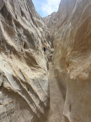
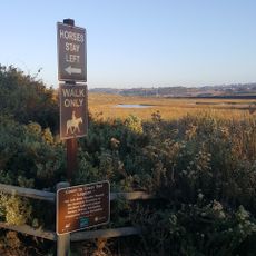
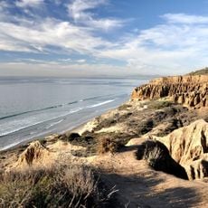
Annie's Canyon Trail, Hiking trail and slot canyon in Encinitas, California.

Annie's Canyon Trail features a narrow passageway carved through sandstone formations, with steep walls creating tight squeezes and sections requiring ladders to ascend through the natural rock corridors toward scenic viewpoints above.

Originally formed over thousands of years through wind and water erosion, this sandstone canyon was historically used by indigenous peoples for shelter and accessing natural resources in the San Diego County region.

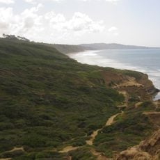
The hiking community values this location for its accessibility and visual appeal, making it a popular destination for photography, wildlife observation, and nature appreciation among Southern California outdoor enthusiasts and families.

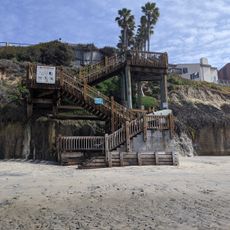
The trail spans approximately 1 mile round-trip with a moderate elevation gain of 500 feet, requiring sturdy footwear and water supplies, especially during warmer months when temperatures can reach uncomfortable levels.

Visitors must navigate through passages so narrow they sometimes require sideways maneuvering and ladder climbing, providing a physically engaging adventure experience uncommon in traditional hiking trails throughout the region.

The community of curious travelers

AroundUs brings together thousands of curated places, local tips, and hidden gems, enriched daily by 60,000 contributors worldwide.

Start exploring
Location
Address
2550 Via Poco, Cardiff, CA 92007, USA
Phone
GPS coordinates
33.00498,-117.26362
Latest update
December 10, 2025 11:51
Around this place
Del Mar Fairgrounds
United States of America

Del Mar Fairgrounds

3.2 km
Torrey Pines State Natural Reserve
United States of America

Torrey Pines State Natural Reserve

9.4 km
Swami's
United States of America

Swami's

4.2 km
Moonlight Beach
United States of America

Moonlight Beach

5.7 km
Torrey Pines State Beach
United States of America

Torrey Pines State Beach

8.2 km
San Elijo State Beach
United States of America

San Elijo State Beach

3 km
San Diego Botanic Garden
United States of America

San Diego Botanic Garden

5.5 km
Cardiff State Beach
United States of America

Cardiff State Beach

1.5 km
Surfing Madonna
United States of America

Surfing Madonna

5.6 km
Encinitas Gardens of Self Realization Fellowship Hermitage
United States of America

Encinitas Gardens of Self Realization Fellowship Hermitage

4.5 km
San Elijo Lagoon
United States of America

San Elijo Lagoon

544 m
San Dieguito River Park
United States of America

San Dieguito River Park

3.3 km
Del Mar Dog Beach
United States of America

Del Mar Dog Beach

3.5 km
San Dieguito Heritage Museum
United States of America

San Dieguito Heritage Museum

6 km
Canfield-Wright House
United States of America

Canfield-Wright House

4.5 km
Olivenhain Town Meeting Hall
United States of America

Olivenhain Town Meeting Hall

5.1 km
Guy and Margaret Fleming House
United States of America

Guy and Margaret Fleming House

9.3 km
Torrey Pines State Beach
United States of America

Torrey Pines State Beach

8.2 km
Grandview Surf Beach
United States of America

Grandview Surf Beach

9.4 km
Rancho Santa Fe Land and Improvement Company Office
United States of America

Rancho Santa Fe Land and Improvement Company Office

5.9 km
Casa Pearl Baker Row
United States of America

Casa Pearl Baker Row

6 km
Casa Charles A. Shaffer
United States of America

Casa Charles A. Shaffer

6.1 km
Torrey Pines Lodge
United States of America

Torrey Pines Lodge

9.4 km
Casa Norman and Florence B. Carmichael
United States of America

Casa Norman and Florence B. Carmichael

7.7 km
Torrey Pines Park Road
United States of America

Torrey Pines Park Road

9.6 km
Casa Reginald M. and Constance Clotfelter Row
United States of America

Casa Reginald M. and Constance Clotfelter Row

6 km
Casa Samuel Bingham
United States of America

Casa Samuel Bingham

7.4 km
Rancho Santa Fe Golf Club
United States of America

Rancho Santa Fe Golf Club

4.6 km
Show the full map
« Annie's Canyon Trail - Hiking trail and slot canyon in Encinitas, California » is provided by Around Us (aroundus.com). Images and texts are derived from Wikimedia project under a Creative Commons license. You are allowed to copy, distribute, and modify copies of this page, under the conditions set by the license, as long as this note is clearly visible.

Discover hidden gems everywhere you go!

From secret cafés to breathtaking viewpoints, skip the crowded tourist spots and find places that match your style. Our app makes it easy with voice search, smart filtering, route optimization, and insider tips from travelers worldwide. Download now for the complete mobile experience.

Around Us App Screenshot

A unique approach to discovering new places

Le Figaro

All the places worth exploring

France Info

A tailor-made excursion in just a few clicks

20 Minutes

Around Us
Travel Guide & Maps
Download

Send to your phone

QR Code
1

Open the camera app on your mobile.

2

Point at the QR code with your camera. A notification will appear.

3

Tap the notification to open the link.