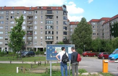
Informationstafel "Führerbunker"
The Informationstafel Führerbunker is a simple marker located on Gertrud-Kolmar Street near In den Ministergärten that identifies where the former bunker once stood. The plaque displays photographs and diagrams of the bunker complex along with basic historical information about the site.
Construction of the bunker began in 1943 and was completed by 1944 as an expanded underground shelter within the Reich Chancellery gardens. After Hitler's death in April 1945, Soviet forces demolished the structure in 1947 using explosives to erase its physical presence.
The marker serves as a focal point for visitors seeking to understand a significant moment in history. It embodies how Berlin chooses to acknowledge difficult chapters through straightforward information rather than elaborate memorials.
The marker is located in an ordinary parking area that is integrated into the surrounding cityscape. The site is easily accessible on foot and can be viewed at any time since it stands in a public space.
The plaque was established in 2006 by the Berlin Underworlds Association and Berlin Senate specifically to prevent myths and false stories from surrounding the site. This deliberate approach reflects Berlin's strategy of confronting difficult chapters of its history with straightforward acknowledgment.
The community of curious travelers
AroundUs brings together thousands of curated places, local tips, and hidden gems, enriched daily by 60,000 contributors worldwide.