Kokoda
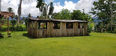
Kokoda is a small town in Sohe District situated at about 370 meters elevation amid green hills and dense forests, serving as the starting point for the famous Kokoda Track. The town features simple buildings, a local airstrip, and a quiet community where Koiari and Motu languages are spoken.
Kokoda was established in 1904 by British colonial administration as a control station and became the site of fierce fighting between Japanese and Australian forces in 1942 during World War II. Japanese troops advanced inland but were pushed back by Australian forces who retook the town in November of that year.
The Koiari people who live along the trail speak their own language and maintain traditions passed down through generations. Visitors can observe village life, hear local songs, and share meals, offering genuine insights into how communities here preserve their heritage.
The area is hot and very wet year-round with frequent rains that keep the jungle green and slow the pace of travel. Visitors should bring sturdy boots, rain gear, and water bottles, and expect simple lodges or guesthouses with local guides available.
In 2009 a plane crashed at Kokoda airstrip killing all 13 people on board, including Australians planning to walk the track. This tragic incident remains a somber moment in the town's recent history and is remembered by the community.
Location: Sohe District
Address: Kokoda Northern Province, Papua New Guinea
GPS coordinates: -8.87839,147.73655
Latest update: January 6, 2026 09:06
This collection brings together about thirty battlefields around the world, witnesses to conflicts that have shaped history over many centuries. Thermopylae recalls the stand of 300 Spartans against the Persian army. The beaches of Normandy remember the landing of 1944 and Europe's liberation. At...
Mount Lamington
47.1 kmMount Victoria, Papua New Guinea
22.4 km
Mount Albert Edward, Papua New Guinea
63.5 kmHuxley Peak
20.7 kmVair Amau Peak
68.6 kmMount Wrong
68.5 kmManaglase Plateau
69 kmMadilogo
40.2 kmGriffiths Sugarloaf
66.9 kmWest Dome
70.3 kmEast Dome
63.4 kmScenic viewpoint
70.3 kmMemorial, war memorial
12 kmScenic viewpoint
70.2 kmKoitaki Country Club
68 kmMemorial
70.9 kmRuins
30.2 kmMemorial, war memorial
12 kmMemorial, war memorial
12 kmWar memorial, memorial
12 kmOwers Corner
60.4 kmSurgeon's Rock
12.8 kmKokoda Plateau Memorial Arch
561 mMemorial, war memorial
114 mMemorial, war memorial
115 mMemorial, war memorial
104 mMemorial, war memorial
109 mCrystal Rapids
70.3 kmVisited this place? Tap the stars to rate it and share your experience / photos with the community! Try now! You can cancel it anytime.
Discover hidden gems everywhere you go!
From secret cafés to breathtaking viewpoints, skip the crowded tourist spots and find places that match your style. Our app makes it easy with voice search, smart filtering, route optimization, and insider tips from travelers worldwide. Download now for the complete mobile experience.
A unique approach to discovering new places❞
— Le Figaro
All the places worth exploring❞
— France Info
A tailor-made excursion in just a few clicks❞
— 20 Minutes